Tributary to Maxan Creek - 197909 - Appendix
Site Location
PSCIS crossing 197909 is located on Tributary to Maxan Creek adjacent to the west side of Maxan Lake located south of Topley, BC. PSCIS crossing 197909 is located on Maxan Creek FSR. Crossing 197909 was located 1.8km upstream from the confluence with Maxan Lake. Crossing 198043 is the responsibility of the Ministry of Forests.
Background
At crossing 197909, Tributary to Maxan Creek is a first order stream with a watershed area upstream of the crossing of approximately 2.1km2. The elevation of the watershed ranges from a maximum of 956m to 788m near the crossing (Table 5.32). No fish have previously been recorded at the site (MoE 2020b; Norris 2020).
fpr::fpr_table_wshd_sum(site_id = my_site) %>%
  fpr::fpr_kable(caption_text = paste0('Summary of derived upstream watershed statistics for PSCIS crossing ', my_site, '.'),
           footnote_text = 'Elev P60 = Elevation at which 60% of the watershed area is above',
scroll = F)| Site | Area Km | Elev Site | Elev Min | Elev Max | Elev Median | Elev P60 | Aspect |
|---|---|---|---|---|---|---|---|
| 197909 | 2.1 | 835 | 788 | 956 | 851 | 847 | E |
| * Elev P60 = Elevation at which 60% of the watershed area is above |
Although the associated reporting could not be located, fisheries assessments were conducted on the stream approximately 170m downstream of the crossing and 50m upstream of the crossing by FINS Consulting Ltd. in 1999 (MoE 2020e). Although information regarding sampling effort is not present, site card notes indicate the site was classified as S6 (non-fish bearing) due to a lack of significant fish habitat.
PSCIS stream crossing 198043 was ranked as a moderate priority for follow up during field assessments because of the presence of modelled habitat upstream and relatively good flows in t he stream when compared to the rest of the culverted streams surveyed in the greater Maxan Creek watershed (Table 5.33. A map of the watershed is provided in map attachment 093L.110.
| Habitat | Potential | Remediation Gain | Remediation Gain (%) |
|---|---|---|---|
| ST Network (km) | 0.7 | 0.7 | 100 |
| ST Lake Reservoir (ha) | 5.7 | 5.7 | 100 |
| ST Wetland (ha) | 27.7 | 27.7 | 100 |
| ST Slopeclass03 Waterbodies (km) | 0.6 | 0.0 | 0 |
| ST Slopeclass03 (km) | 0.0 | 0.0 | – |
| ST Slopeclass05 (km) | 0.1 | 0.1 | 100 |
| ST Slopeclass08 (km) | 0.0 | 0.0 | – |
| ST Spawning (km) | 0.0 | 0.0 | – |
| ST Rearing (km) | 0.0 | 0.0 | – |
| CH Spawning (km) | 0.0 | 0.0 | – |
| CH Rearing (km) | 0.0 | 0.0 | – |
| CO Spawning (km) | 0.0 | 0.0 | – |
| CO Rearing (km) | 0.2 | 0.2 | 100 |
| CO Rearing (ha) | 13.8 | 0.0 | 0 |
| SK Spawning (km) | 0.0 | 0.0 | – |
| SK Rearing (km) | 0.0 | 0.0 | – |
| SK Rearing (ha) | – | 0.0 | – |
| All Spawning (km) | 0.0 | 0.0 | – |
| All Rearing (km) | 0.2 | 0.2 | 100 |
| All Spawning Rearing (km) | 0.2 | 0.2 | 100 |
| * Model data is preliminary and subject to adjustments. |
Stream Characteristics at Crossing
At the time of the survey, PSCIS crossing 197909 was comprised of an un-embedded and non-backwatered round culvert (Table 5.34). Water temperature was 12\(^\circ\)C, pH was 7.2 and conductivity was 106uS/cm.
| Location and Stream Data |
|
Crossing Characteristics | – |
|---|---|---|---|
| Date | 2021-08-30 | Crossing Sub Type | Round Culvert |
| PSCIS ID | 197909 | Diameter (m) | 0.6 |
| External ID | – | Length (m) | 16 |
| Crew | AI KP | Embedded | No |
| UTM Zone | 9 | Depth Embedded (m) | – |
| Easting | 687557 | Resemble Channel | No |
| Northing | 6020572 | Backwatered | No |
| Stream | Tributary to Maxan Creek | Percent Backwatered | – |
| Road | Maxan Creek FSR | Fill Depth (m) | 2.5 |
| Road Tenure | FLNR DND 7735 | Outlet Drop (m) | 0 |
| Channel Width (m) | 0.9 | Outlet Pool Depth (m) | 0.65 |
| Stream Slope (%) | 4 | Inlet Drop | Yes |
| Beaver Activity | Yes | Slope (%) | 3 |
| Habitat Value | Medium | Valley Fill | Deep Fill |
| Final score | 29 | Barrier Result | Barrier |
| Fix type | Replace Structure with Streambed Simulation CBS | Fix Span / Diameter | 3 |
Photos: From top left clockwise: Road/Site Card, Barrel, Outlet, Downstream, Upstream, Inlet.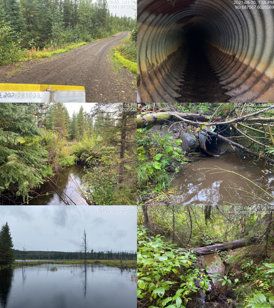
|
|||
| Comments: Habitat value is low to medium. Large beaver influenced lake upstream with two dams ~1.5m high at 10m and 30m upstream. Inlet blocked. Water at inlet is level with the top of the culvert. At 4m downstream is a 1m high beaver dam. 13:23 |
Stream Characteristics Downstream
The stream was surveyed downstream from crossing 197909 for 400m (Figures 5.49 - 5.50). Total cover amount was rated as moderate with overhanging vegetation dominant. Cover was also present as undercut banks. The average channel width was 1.3m, the average wetted width was 1.3m, and the average gradient was 3.2%. Substrate was composed of fines. At approximately 300m downstream of the culvert the stream became wider with glide habitat to ~50cm in depth resulting from sediments deposited by a failure on the steep north canyon wall. Habitat was rated as low value for salmonid rearing and spawning due to the small size of the stream, low flows and fine substrate.
Stream Characteristics Upstream
The stream was surveyed upstream from crossing 197909 for 100m to the location of a series of large beaver dams (Figures 5.51 - 5.52). Substrate was composed of fines. Cover was present as overhanging vegetation and as deep pool due to beaver influenced water impoundment. Habitat value was rated as moderate value as the area could provide significant amounts of rearing habitat for rainbow and coho if access from downstream was possible.
Structure Remediation and Cost Estimate
Should restoration/maintenance activities proceed at the site, replacement of PSCIS crossing 197909 with a clear span bridge is recommended. The cost of the work is estimated at $40,000 for a cost benefit of 5.6 linear m/$1000 and 7.3 m2/$1000.
Conclusion
Although past assessment work in the watershed indicates stream is likely non-fish bearing (MoE 2020e), there was 0.2km of habitat and 27.7ha of wetland type habitat modelled upstream of crossing 197909 with areas surveyed rated as moderate value for rainbow trout and coho rearing. Crossing 197909 was ranked as a low priority for proceeding to design for removal however this ranking could be revisited in the future should fish presence or potential for fish presence be confirmed through subsequent survey activities.
tab_hab_summary %>%
  filter(Site  == my_site) %>%
  # select(-Site) %>%
  fpr::fpr_kable(caption_text = paste0('Summary of habitat details for PSCIS crossing ', my_site, '.'),
scroll = F) | Site | Location | Length Surveyed (m) | Channel Width (m) | Wetted Width (m) | Pool Depth (m) | Gradient (%) | Total Cover | Habitat Value |
|---|---|---|---|---|---|---|---|---|
| 197909 | Downstream | 400 | 1.3 | 1.3 | 0.5 | 3.2 | abundant | low |
| 197909 | Upstream | 100 | 1.3 | – | – | – | moderate | moderate |
my_photo1 = fpr::fpr_photo_pull_by_str(str_to_pull = '_d1_')

my_caption1 = paste0('Habitat downstream of PSCIS crossing ', my_site, '.')


# fpr::fpr_photo_flip(site_id = 1802488, str_to_pull = '6257')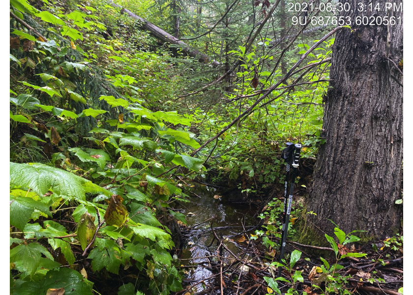
Figure 5.49: Habitat downstream of PSCIS crossing 197909.
my_photo2 = fpr::fpr_photo_pull_by_str(str_to_pull = '_d2_')

my_caption2 = paste0('Habitat downstream of PSCIS crossing ', my_site, '.')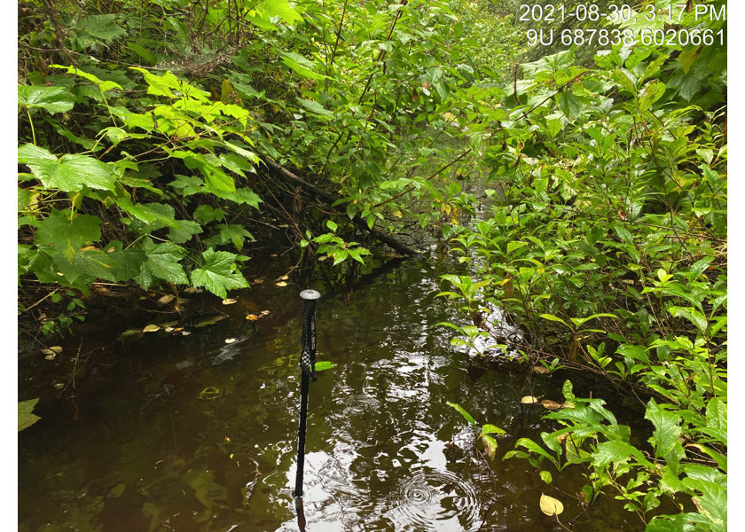
Figure 5.50: Habitat downstream of PSCIS crossing 197909.
my_caption <- paste0('Left: ', my_caption1, ' Right: ', my_caption2)

knitr::include_graphics(my_photo1)
knitr::include_graphics("fig/pixel.png")
knitr::include_graphics(my_photo2)
my_photo1 = fpr::fpr_photo_pull_by_str(str_to_pull = '_u1_')
my_caption1 = paste0('Habitat upstream of PSCIS crossing ', my_site, '.')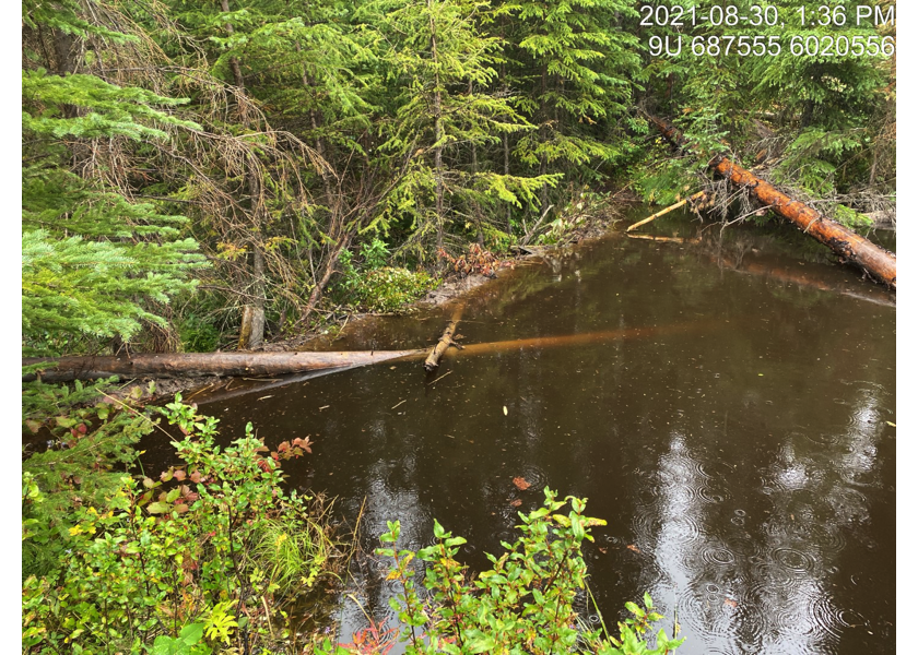
Figure 5.51: Habitat upstream of PSCIS crossing 197909.
my_photo2 = fpr::fpr_photo_pull_by_str(str_to_pull = '_u2_')

my_caption2 = paste0('Habitat upstream of PSCIS crossing ', my_site, '.')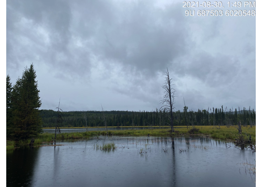
Figure 5.52: Habitat upstream of PSCIS crossing 197909.
my_caption <- paste0('Left: ', my_caption1, ' Right: ', my_caption2)

knitr::include_graphics(my_photo1)
knitr::include_graphics("fig/pixel.png")
knitr::include_graphics(my_photo2)