Toboggan Creek - 57944 - Appendix
Site Location
PSCIS crossing 57944 is located on Toboggan Creek within the Coryatsaqua 2 (Moricetown) Indian Reserve at Moricetown, BC. PSCIS crossing 57944 is located on Highway 16. Crossing 57944 was located 0.2km upstream from the confluence with the Bulkley River. Crossing 57944 is the responsibility of the Ministry of Transportation and Infrastructure.
Background
At crossing 57944, Toboggan Creek is a fifth order stream with a watershed area upstream of the crossing of approximately 119.9km2. The elevation of the watershed ranges from a maximum of 2586m to 412m near the crossing (Table 5.1). Upstream of crossing 57944, longnose sucker, cutthroat trout, pink salmon, coho salmon, rainbow trout, steelhead, kokanee, sockeye salmon, chinook salmon, mountain whitefish, dolly varden, sculpin (general), and lamprey (general) have previously been recorded (MoE 2020b; Norris 2020). There is a wealth of information available for Toboggan Creek with numerous references available through the Skeena Salmon Data Centre.
fpr::fpr_table_wshd_sum(site_id = my_site) %>%
  fpr::fpr_kable(caption_text = paste0('Summary of derived upstream watershed statistics for PSCIS crossing ', my_site, '.'),
           footnote_text = 'Elev P60 = Elevation at which 60% of the watershed area is above',
scroll = F)| Site | Area Km | Elev Site | Elev Min | Elev Max | Elev Median | Elev P60 | Aspect |
|---|---|---|---|---|---|---|---|
| 57944 | 119.9 | 413 | 412 | 2586 | 629 | 547 | SE |
| * Elev P60 = Elevation at which 60% of the watershed area is above |
The Toboggan Creek Hatchery facility is located on the stream approximately 8.7km upstream of Highway 16. The hatchery has been operated by the Toboggan Creek Salmon & Steelhead Enhancement Society since 1985. The hatchery serves to enhance coho and chinook stocks in the watershed as well as help assess coho stock with coded wire tag hatchery releases (Smithers District Chamber of Commerce 2022; Wilson and Rabnett 2007). Office of Wet’suwet’en (2016) report that Toboggan hatchery fish have been used to enhance the Bulkley mainstem, Maxan Creek and Buck Creek with chinook fry and smolt.
Office of Wet’suwet’en (2016) note that Wet’suwet’en Knowledge documents Toboggan Lake as a sockey nursery lake. Additionally, as cited in Office of Wet’suwet’en (2016), K. Rabnett, Holland, and Gottesfeld (2017) report a historic fishery at the outlet of Toboggan Lake where an extirpated stock of sockeye stock existed.
Toboggan Lake is 25ha in size and modelling indicates an additional 256ha of wetland upstream of the highway. Significantly sized lakes within watersheds can throttle high freshet and storm flows often resulting in increased stability downstream and conditions conducive to egg incubation and juvenile rearing.
Works to remediate fish passage issues at PSCIS stream crossing 57944 were conducted in 2015 with backwatering completed through installation of boulders downstream of the crossing (McCarthy and Fernando 2015). Comparison of historic PSCIS photos and data between 2021 and 2012 indicate that the historical recorded outlet drop of 90cm has been reduced to 0cm as a result of the works. Sandra Devcic, DFO Restoration Engineer (pers. comm.) has noted that developing a design to replace the crossing with an open bottom structure presents challenges due to the stream crossing location at the bottom of a hill and on a corner of the highway.
In 2021 at the time of the assessment, pink salmon spawners were noted as present at the enumeration fences near the hatchery indicating that the highway structure was passable to these relatively weak swimmers in 2021.
PSCIS stream crossing 57944 was ranked as a high priority for follow up by Wilson and Rabnett (2007), Irvine (2018), Irvine (2021) and Mazany-Wright et al. (2021) because of significant amounts of habitat modelled as upstream of the crossing. A summary of habitat modelling outputs is presented in Table 5.2. A map of the watershed is provided in map attachment 093L.122.
| Habitat | Potential | Remediation Gain | Remediation Gain (%) |
|---|---|---|---|
| ST Network (km) | 96.3 | 33.0 | 34 |
| ST Lake Reservoir (ha) | 16.9 | 15.7 | 93 |
| ST Wetland (ha) | 256.1 | 93.5 | 37 |
| ST Slopeclass03 Waterbodies (km) | 13.6 | 0.0 | 0 |
| ST Slopeclass03 (km) | 38.5 | 18.1 | 47 |
| ST Slopeclass05 (km) | 18.1 | 2.8 | 15 |
| ST Slopeclass08 (km) | 11.3 | 1.1 | 10 |
| ST Spawning (km) | 16.6 | 13.8 | 83 |
| ST Rearing (km) | 51.7 | 19.7 | 38 |
| CH Spawning (km) | 16.6 | 13.8 | 83 |
| CH Rearing (km) | 28.2 | 15.9 | 56 |
| CO Spawning (km) | 23.5 | 16.2 | 69 |
| CO Rearing (km) | 52.4 | 25.6 | 49 |
| CO Rearing (ha) | 122.8 | 0.0 | 0 |
| SK Spawning (km) | 0.0 | 0.0 | – |
| SK Rearing (km) | 0.0 | 0.0 | – |
| SK Rearing (ha) | – | 0.0 | – |
| All Spawning (km) | 23.5 | 16.2 | 69 |
| All Rearing (km) | 63.5 | 26.6 | 42 |
| All Spawning Rearing (km) | 63.5 | 26.6 | 42 |
| * Model data is preliminary and subject to adjustments. |
Stream Characteristics at Crossing
At the time of the survey, PSCIS crossing 57944 was un-embedded, non-backwatered and ranked as a barrier to upstream fish passage according to the provincial protocol (MoE 2011b) (Table 5.3). Water temperature was 8\(^\circ\)C, pH was 8.2 and conductivity was 74uS/cm.
| Location and Stream Data |
|
Crossing Characteristics | – |
|---|---|---|---|
| Date | 2021-09-15 | Crossing Sub Type | Oval Culvert |
| PSCIS ID | 57944 | Diameter (m) | 7 |
| External ID | – | Length (m) | 30 |
| Crew | AI | Embedded | No |
| UTM Zone | 9 | Depth Embedded (m) | – |
| Easting | 607729 | Resemble Channel | No |
| Northing | 6089383 | Backwatered | No |
| Stream | Toboggan Creek | Percent Backwatered | – |
| Road | Highway 16 | Fill Depth (m) | 2 |
| Road Tenure | Highway | Outlet Drop (m) | 0 |
| Channel Width (m) | 8.5 | Outlet Pool Depth (m) | 2 |
| Stream Slope (%) | 2.1 | Inlet Drop | No |
| Beaver Activity | No | Slope (%) | 3 |
| Habitat Value | High | Valley Fill | Deep Fill |
| Final score | 29 | Barrier Result | Barrier |
| Fix type | Replace with New Open Bottom Structure | Fix Span / Diameter | 13.5 |
Photos: From top left clockwise: Road/Site Card, Barrel, Outlet, Downstream, Upstream, Inlet.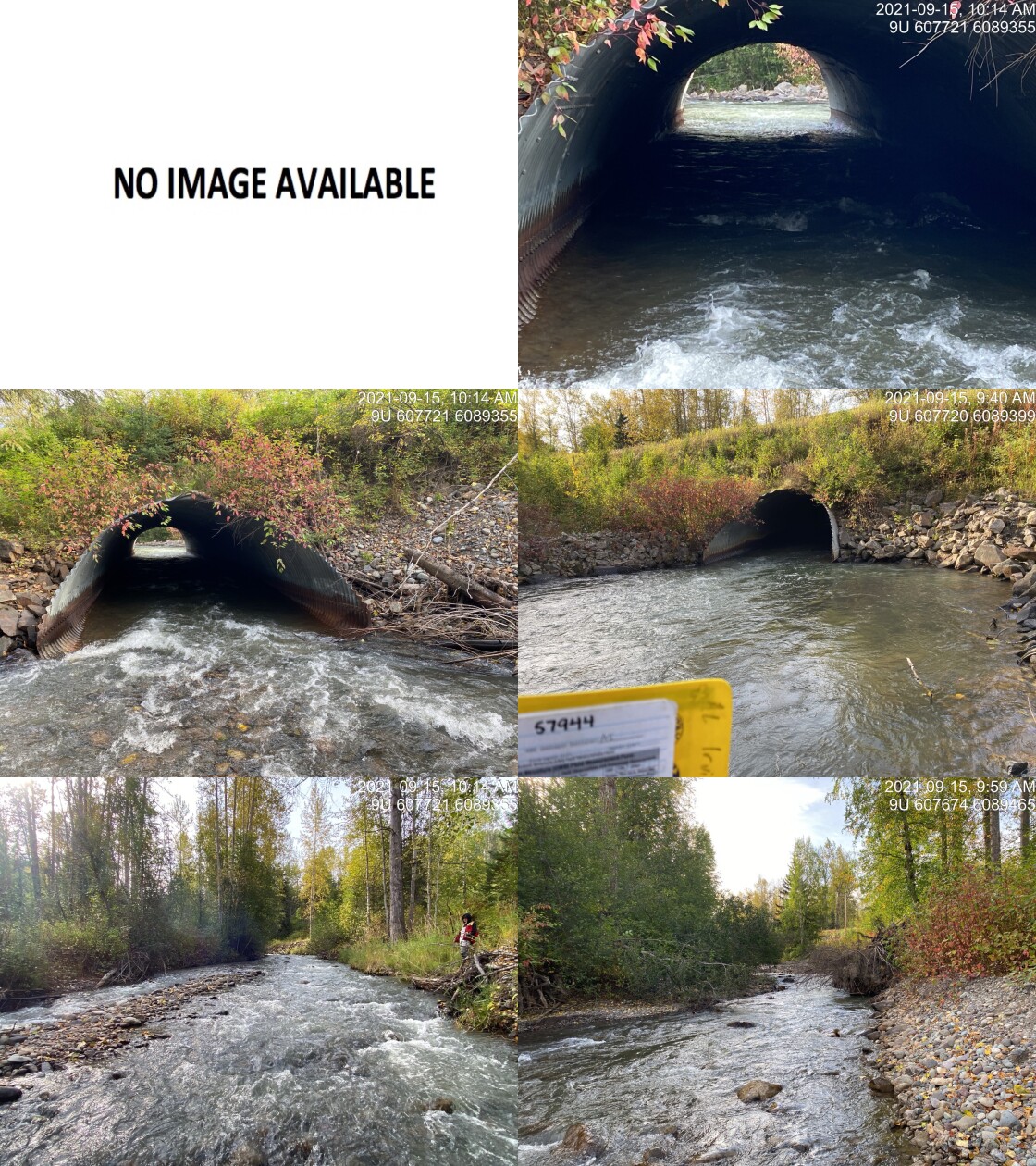
|
|||
| Comments: Oval culvert. 9:34 |
Stream Characteristics Downstream
The stream was surveyed downstream from crossing 57944 for 140m to the conflence with the Bulkley River (Figures 5.1 - 5.2). Total cover amount was rated as moderate with undercut banks dominant. Cover was also present as small woody debris, large woody debris, boulders, and overhanging vegetation. The average channel width was 13.9m, the average wetted width was 6.7m and the average gradient was 5.5%. The dominant substrate was cobbles with boulders subdominant. Although rated as an important migration corridor, the habitat was rated as medium value for salmonid rearing and spawning.
Stream Characteristics Upstream
The stream was surveyed upstream from crossing 57944 for 880m (Figures 5.3 - 5.4). Total cover amount was rated as moderate with large woody debris dominant. Cover was also present as small woody debris and boulders., Total cover amount was rated as moderate with overhanging vegetation dominant. Cover was also present as small woody debris and boulders. The average channel width was 8.5m, the average wetted width was 6.7m and the average gradient was 2.1%. The dominant substrate was cobbles with gravels subdominant. The first 50 - 100m upstream of crossing channel and banks were noted as armoured with riprap. Abundant gravels suitable for resident and anadromous salmonids were noted throughout. The habitat was rated as high value as an important migration corridor containing suitable spawning habitat and having moderate rearing potential.
The stream was also surveyed at a second location upstream of the hatchery adjacent to the Owen Road bridge for 150m (Figures 5.5 - 5.6). Total cover amount was rated as abundant with deep pools dominant. Cover was also present as small woody debris, undercut banks, and overhanging vegetation. The average channel width was 12.6m, the average wetted width was 10.5m and the average gradient was 0.5%. The dominant substrate was gravels with fines subdominant. The habitat was rated as high value for salmon rearing and spawning.
Structure Remediation and Cost Estimate
Should restoration/maintenance activities proceed, replacement of PSCIS crossing 57944 with a bridge (13.5m span) is recommended. The cost of the work is estimated at $8,100,000 for a cost benefit of 6.5 linear m/$1000 and 54.9 m2/$1000.
Conclusion
There was 52.4km of habitat modelled upstream of crossing 57944 with areas survyed rated as high value for salmonid rearing and spawning. Crossing 57944 was ranked as a high priority for proceeding to design for replacement. Toboggan Creek represents an extremely important system for the Bulkley River system in terms of fisheries values, it’s function for outreach within the community as well as it’s contribution to stock enhancement and assessment. Development of a plan to replace the crossing with a bridge may be considered as a prudent step to mitigating risks of a blow out of the backwatering works currently in place downstream and a return to conditions similiar to those observed historically when a significant outlet drop was present (Figures 5.7 - 5.8).
tab_hab_summary %>%
  filter(Site  == my_site) %>%
  # select(-Site) %>%
  fpr::fpr_kable(caption_text = paste0('Summary of habitat details for PSCIS crossing ', my_site, '.'),
scroll = F) | Site | Location | Length Surveyed (m) | Channel Width (m) | Wetted Width (m) | Pool Depth (m) | Gradient (%) | Total Cover | Habitat Value |
|---|---|---|---|---|---|---|---|---|
| 57944 | Downstream | 140 | 13.9 | 10.1 | 0.3 | 5.5 | moderate | medium |
| 57944 | Upstream | 880 | 8.5 | 6.7 | 0.5 | 2.1 | moderate | high |
| 57944 | Upstream2 | 150 | 12.6 | 10.5 | 2.0 | 0.5 | abundant | high |
my_photo1 = fpr::fpr_photo_pull_by_str(str_to_pull = '_d1_')

my_caption1 = paste0('Typical habitat downstream of PSCIS crossing ', my_site, '.')


# fpr::fpr_photo_flip(site_id = 1802488, str_to_pull = '6257')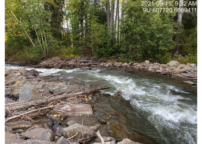
Figure 5.1: Typical habitat downstream of PSCIS crossing 57944.
my_photo2 = fpr::fpr_photo_pull_by_str(str_to_pull = '_d2_')

my_caption2 = paste0('Typical habitat downstream of PSCIS crossing ', my_site, '.')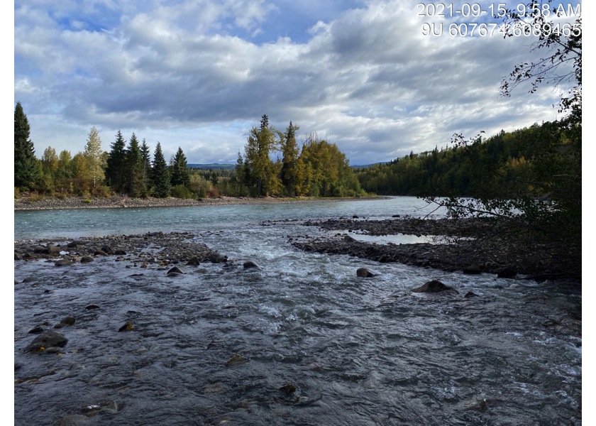
Figure 5.2: Typical habitat downstream of PSCIS crossing 57944.
my_caption <- paste0('Left: ', my_caption1, ' Right: ', my_caption2)

knitr::include_graphics(my_photo1)
knitr::include_graphics("fig/pixel.png")
knitr::include_graphics(my_photo2)
my_photo1 = fpr::fpr_photo_pull_by_str(str_to_pull = '_u1_')
my_caption1 = paste0('Typical habitat upstream of PSCIS crossing ', my_site, '.')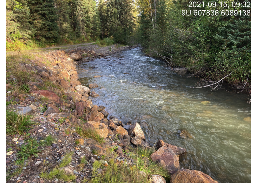
Figure 5.3: Typical habitat upstream of PSCIS crossing 57944.
my_photo2 = fpr::fpr_photo_pull_by_str(str_to_pull = '_u2_')

my_caption2 = paste0('Typical habitat upstream of PSCIS crossing ', my_site, '.')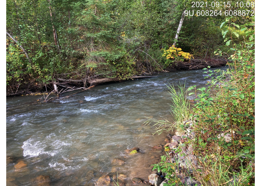
Figure 5.4: Typical habitat upstream of PSCIS crossing 57944.
my_caption <- paste0('Left: ', my_caption1, ' Right: ', my_caption2)

knitr::include_graphics(my_photo1)
knitr::include_graphics("fig/pixel.png")
knitr::include_graphics(my_photo2)
my_photo1 = fpr::fpr_photo_pull_by_str(str_to_pull = '_u3_')
my_caption1 = paste0('Typical habitat upstream of PSCIS crossing ', my_site, '.')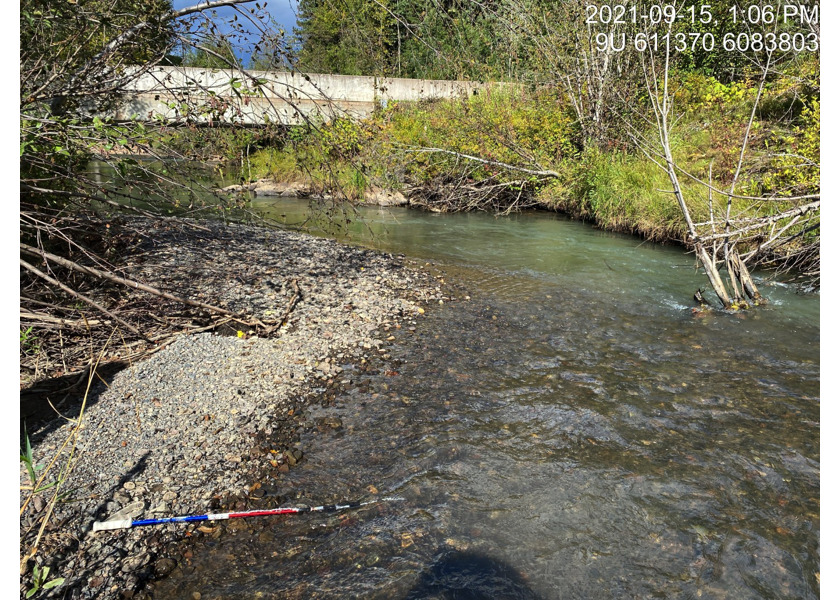
Figure 5.5: Typical habitat upstream of PSCIS crossing 57944.
my_photo2 = fpr::fpr_photo_pull_by_str(str_to_pull = '_u4_')

my_caption2 = paste0('Typical habitat upstream of PSCIS crossing ', my_site, '.')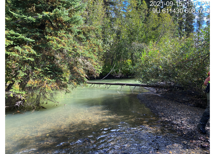
Figure 5.6: Typical habitat upstream of PSCIS crossing 57944.
my_caption <- paste0('Left: ', my_caption1, ' Right: ', my_caption2)

knitr::include_graphics(my_photo1)
knitr::include_graphics("fig/pixel.png")
knitr::include_graphics(my_photo2)
my_photo1 = fpr::fpr_photo_pull_by_str(str_to_pull = '_2012a_')
my_caption1 = paste0('Outlet of PSCIS crossing ', my_site, ' in 2012. Photo from PSCIS.')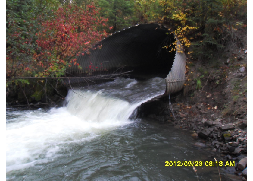
Figure 5.7: Outlet of PSCIS crossing 57944 in 2012. Photo from PSCIS.
my_photo2 = fpr::fpr_photo_pull_by_str(str_to_pull = '_2012b_')

my_caption2 = paste0('Inlet of PSCIS crossing ', my_site, ' in 2012. Photo from PSCIS.')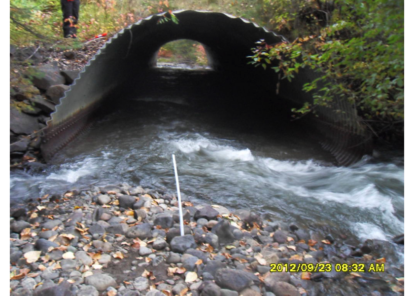
Figure 5.8: Inlet of PSCIS crossing 57944 in 2012. Photo from PSCIS.
my_caption <- paste0('Left: ', my_caption1, ' Right: ', my_caption2)

knitr::include_graphics(my_photo1)
knitr::include_graphics("fig/pixel.png")
knitr::include_graphics(my_photo2)