McBride Creek - 198000 - Appendix
Site Location
PSCIS crossing 198000 is located on McBride Creek approximatley 75km west of Houston, BC. PSCIS crossing 198000 is located on Nanika FSR. Crossing 198000 was located 10.1km upstream from the confluence with Morice Lake and approximately 200m downstream from the outlet of McBride Lake. Crossing 197975 is the responsibility of the Ministry of Forests and is identified as crossing R5-049 in the Coastal Bridge Registry.
Background
At crossing 198000, McBride Creek is a fourth order stream with a watershed area upstream of the crossing of approximately 83.5km2. The elevation of the watershed ranges from a maximum of 1597m to 799m at the crossing (Table 5.68). Upstream of crossing 198000, longnose sucker, white sucker, largescale sucker, peamouth chub, leopard dace, redside shiner, burbot, lake whitefish, cutthroat trout, coho salmon, rainbow trout, mountain whitefish, dolly varden, lake trout, and prickly sculpin have previously been recorded (MoE 2020b; Norris 2020).
fpr::fpr_table_wshd_sum(site_id = my_site) %>%
  fpr::fpr_kable(caption_text = paste0('Summary of derived upstream watershed statistics for PSCIS crossing ', my_site, '.'),
           footnote_text = 'Elev P60 = Elevation at which 60% of the watershed area is above',
scroll = F)| Site | Area Km | Elev Site | Elev Min | Elev Max | Elev Median | Elev P60 | Aspect |
|---|---|---|---|---|---|---|---|
| 198000 | 83.5 | 799 | – | 1597 | 908 | 887 | SSW |
| * Elev P60 = Elevation at which 60% of the watershed area is above |
PSCIS stream crossing 198000 was ranked as a high priority for follow up by Irvine (2021) because of the large amount of potential habitat upstream of the crossing. A summary of habitat modelling outputs is presented in Table 5.69. A map of the watershed is provided in map attachment 093L.102.
| Habitat | Potential | Remediation Gain | Remediation Gain (%) |
|---|---|---|---|
| ST Network (km) | 84.1 | 31.8 | 38 |
| ST Lake Reservoir (ha) | 845.9 | 782.1 | 92 |
| ST Wetland (ha) | 61.8 | 26.0 | 42 |
| ST Slopeclass03 Waterbodies (km) | 26.4 | 0.0 | 0 |
| ST Slopeclass03 (km) | 21.0 | 4.2 | 20 |
| ST Slopeclass05 (km) | 16.2 | 3.7 | 23 |
| ST Slopeclass08 (km) | 13.8 | 3.5 | 25 |
| ST Spawning (km) | 2.5 | 2.5 | 100 |
| ST Rearing (km) | 21.9 | 9.4 | 43 |
| CH Spawning (km) | 2.5 | 2.5 | 100 |
| CH Rearing (km) | 5.9 | 5.0 | 85 |
| CO Spawning (km) | 14.0 | 5.7 | 41 |
| CO Rearing (km) | 20.1 | 7.3 | 36 |
| CO Rearing (ha) | 35.9 | 0.0 | 0 |
| SK Spawning (km) | 0.7 | 0.7 | 100 |
| SK Rearing (km) | 27.8 | 27.8 | 100 |
| SK Rearing (ha) | 782.1 | 0.0 | 0 |
| All Spawning (km) | 14.0 | 5.7 | 41 |
| All Rearing (km) | 51.6 | 38.2 | 74 |
| All Spawning Rearing (km) | 51.6 | 38.2 | 74 |
| * Model data is preliminary and subject to adjustments. |
Stream Characteristics at Crossing
At the time of the survey, PSCIS crossing 198000 was un-embedded, non-backwatered and ranked as a potential barrier to upstream fish passage according to the provincial protocol 5.70">MoE (2011b). Water temperature was 12\(^\circ\)C, pH was 7.3 and conductivity was 366uS/cm. Surveys were conducted with a remotely piloted aircraft immediately upstream and downstream of the crossing with resulting images stitched into an orthomosaic and 3-dimensional model presented in Figures 5.86 - 5.87.
| Location and Stream Data |
|
Crossing Characteristics | – |
|---|---|---|---|
| Date | 2021-09-02 | Crossing Sub Type | Oval Culvert |
| PSCIS ID | 198000 | Diameter (m) | 3.9 |
| External ID | – | Length (m) | 16 |
| Crew | KP AI | Embedded | No |
| UTM Zone | 9 | Depth Embedded (m) | – |
| Easting | 605511 | Resemble Channel | No |
| Northing | 5992667 | Backwatered | No |
| Stream | McBride Creek | Percent Backwatered | – |
| Road | Nanika FSR | Fill Depth (m) | 0.8 |
| Road Tenure | FLNR DND 4656 | Outlet Drop (m) | 0.05 |
| Channel Width (m) | 9 | Outlet Pool Depth (m) | 0.8 |
| Stream Slope (%) | 2 | Inlet Drop | No |
| Beaver Activity | No | Slope (%) | 0.5 |
| Habitat Value | High | Valley Fill | Deep Fill |
| Final score | 19 | Barrier Result | Potential |
| Fix type | Replace with New Open Bottom Structure | Fix Span / Diameter | 14 |
Photos: From top left clockwise: Road/Site Card, Barrel, Outlet, Downstream, Upstream, Inlet.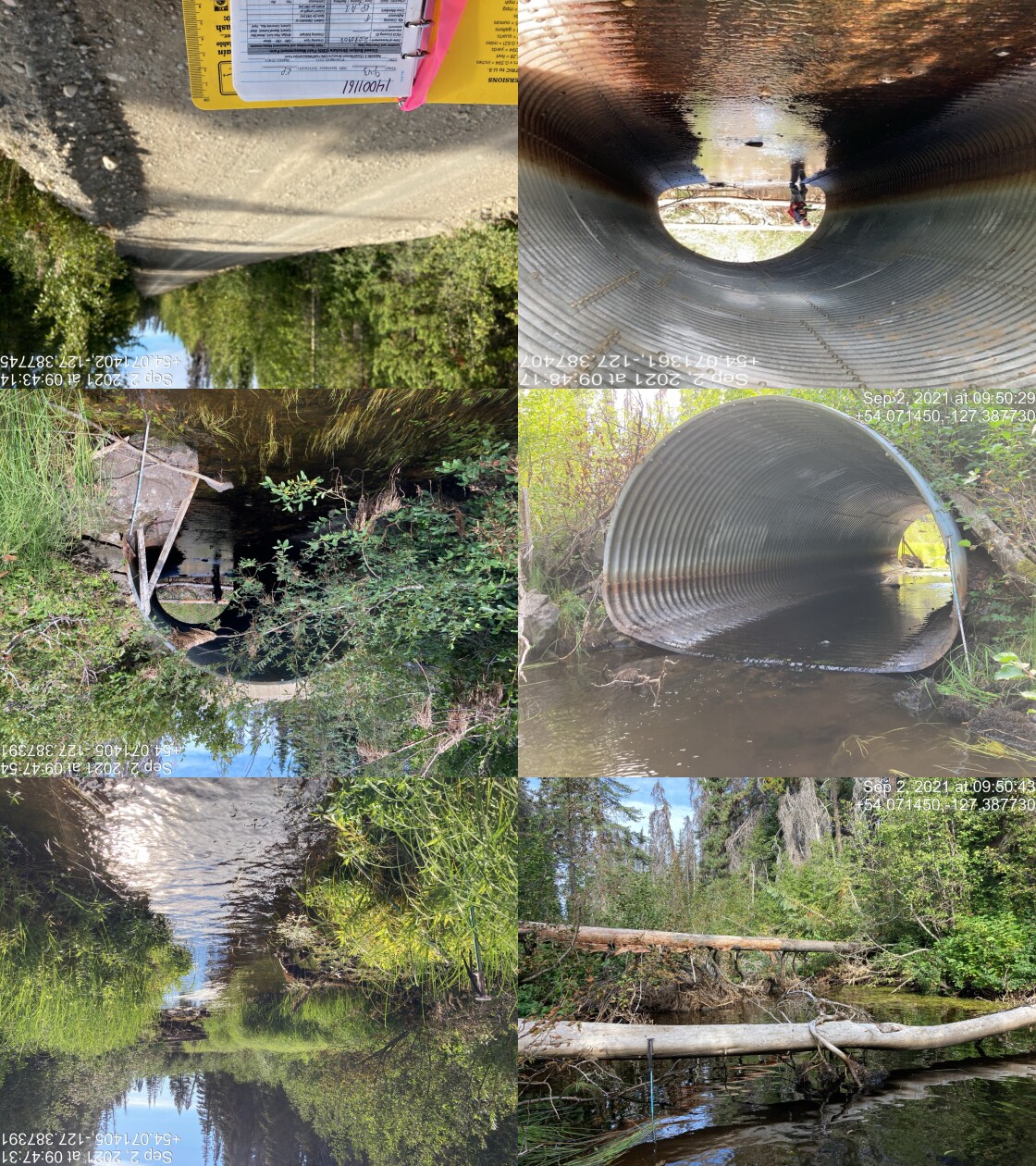
|
|||
| Comments: Laser level for slope. Channel width difficult to measure due to vegetation. 9:43 |
model_url <- '<iframe src="https://www.mapsmadeeasy.com/maps/public/009dbfef7a924182933029a5927ceb98" scrolling="no" title="Maps Made Easy" width="100%" height="600" frameBorder ="0"></iframe>'

knitr::asis_output(model_url)
my_photo = 'fig/pixel.png'
my_caption = paste0('Orthomosaic of habitat immediately upstream and downstream of McBride Creek. To zoom press "shift" and scroll.')
knitr::include_graphics(my_photo, dpi = NA)Figure 5.86: Orthomosaic of habitat immediately upstream and downstream of McBride Creek. To zoom press “shift” and scroll.
model_url <- '<iframe src="https://www.mapsmadeeasy.com/maps/public_3D/009dbfef7a924182933029a5927ceb98" scrolling="no" title="Maps Made Easy" width="100%" height="600" frameBorder ="0"></iframe>'

knitr::asis_output(model_url)
my_photo = 'fig/pixel.png'
my_caption = paste0('3D model of habitat immediately upstream and downstream of McBride Creek. To zoom press "shift" and scroll.')
knitr::include_graphics(my_photo, dpi = NA)Figure 5.87: 3D model of habitat immediately upstream and downstream of McBride Creek. To zoom press “shift” and scroll.
Stream Characteristics Downstream
The stream was surveyed downstream from the culvert for 300m (Figures 5.88 - 5.89). Total cover amount was rated as with instream vegetation dominant. Cover was also present as small woody debris, large woody debris, and overhanging vegetation (Table 5.71). The average channel width was 6.2m, the average wetted width was 5.1m and the average gradient was 1.2%. The dominant substrate was gravels with cobbles subdominant. The habitat was rated as high value for salmonid rearing and spawning.
Stream Characteristics Upstream of 198000 and downstream of 197975
The stream was surveyed immediately upstream from 198000 for approximately 135m (Figures 5.90 - 5.91). Within the area surveyed, total cover amount was rated as with large woody debris dominant. Cover was also present as small woody debris, overhanging vegetation, and instream vegetation (Table 5.71). The average channel width was 5.5m, the average wetted width was 4.4m and the average gradient was 1%. The dominant substrate was gravels with fines subdominant. Habitat value was rated as high value for resident salmonid rearing and spawning.
Structure Remediation and Cost Estimate
Should restoration/maintenance activities proceed at the site, replacement of PSCIS crossing 198000 with a bridge (14m span) is recommended.
# The cost of the work is estimated at \$`r format(my_cost_estimate() %>% pull(cost_est_1000s) * 1000, big.mark = ',')` for a cost benefit of `r as.character(my_cost_estimate() %>% pull(cost_net))` linear m/\$1000 and `r as.character(my_cost_estimate() %>% pull(cost_area_net))`m^2^/\$1000. Conclusion
There was 198000 is 20.1km of habitat upstream of crossing rated as high value for salmonid rearing and spawning. Crossing 198000 was ranked as a moderate priority for proceeding to design for replacement.
tab_hab_summary %>%
  filter(Site  == my_site) %>%
  # select(-Site) %>%
  fpr::fpr_kable(caption_text = paste0('Summary of habitat details for PSCIS crossing ', my_site, '.'),
scroll = F) | Site | Location | Length Surveyed (m) | Channel Width (m) | Wetted Width (m) | Pool Depth (m) | Gradient (%) | Total Cover | Habitat Value |
|---|---|---|---|---|---|---|---|---|
| 198000 | Downstream | 300 | 6.2 | 5.1 | – | 1.2 | moderate | high |
| 198000 | Upstream | 135 | 5.5 | 4.4 | – | 1.0 | moderate | high |
my_photo1 = fpr::fpr_photo_pull_by_str(str_to_pull = '_d1_')

my_caption1 = paste0('Typical habitat downstream of PSCIS crossing ', my_site, '.')


# fpr::fpr_photo_flip(site_id = 1802488, str_to_pull = '6257')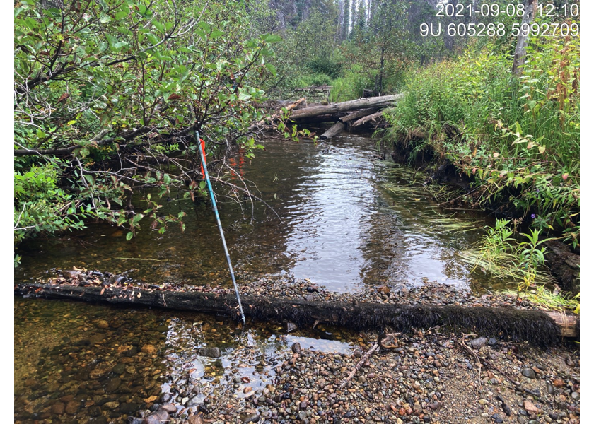
Figure 5.88: Typical habitat downstream of PSCIS crossing 198000.
my_photo2 = fpr::fpr_photo_pull_by_str(str_to_pull = '_d2_')

my_caption2 = paste0('Typical habitat downstream of PSCIS crossing ', my_site, '.')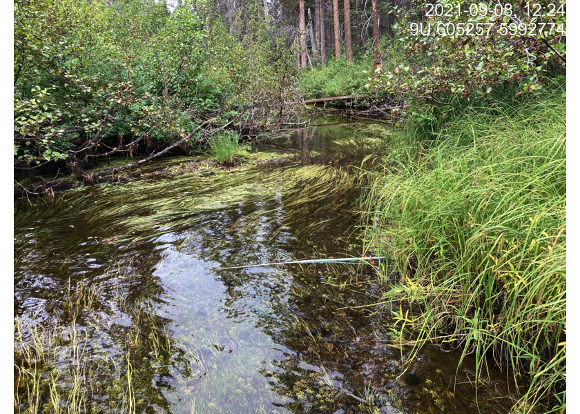
Figure 5.89: Typical habitat downstream of PSCIS crossing 198000.
my_caption <- paste0('Left: ', my_caption1, ' Right: ', my_caption2)

knitr::include_graphics(my_photo1)
knitr::include_graphics("fig/pixel.png")
knitr::include_graphics(my_photo2)
my_photo1 = fpr::fpr_photo_pull_by_str(str_to_pull = '_u1_')
my_caption1 = paste0('Typical habitat upstream of PSCIS crossing ', my_site, '.')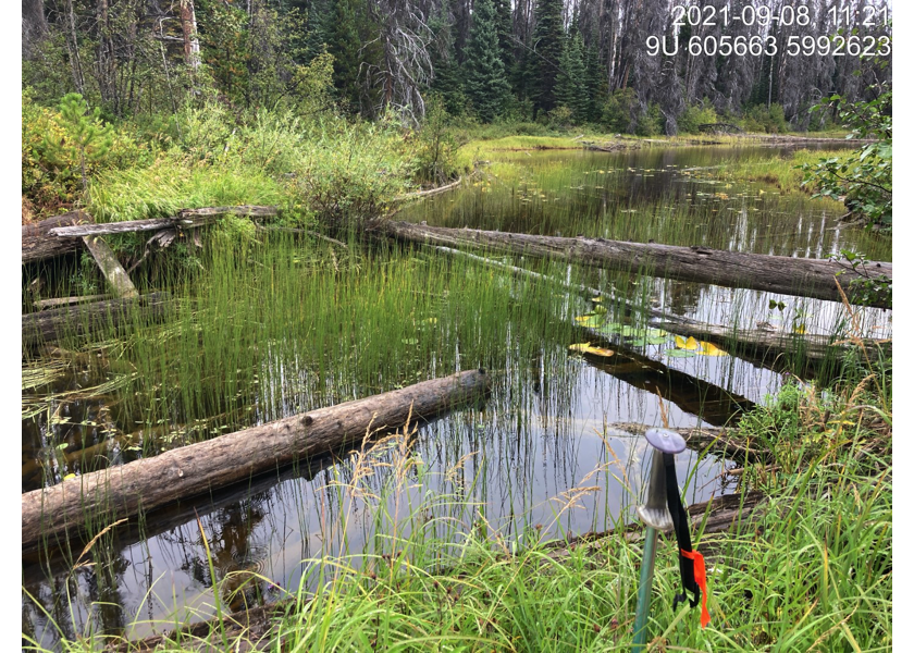
Figure 5.90: Typical habitat upstream of PSCIS crossing 198000.
my_photo2 = fpr::fpr_photo_pull_by_str(str_to_pull = '_u2_')

my_caption2 = paste0('Typical habitat upstream of PSCIS crossing ', my_site, '.')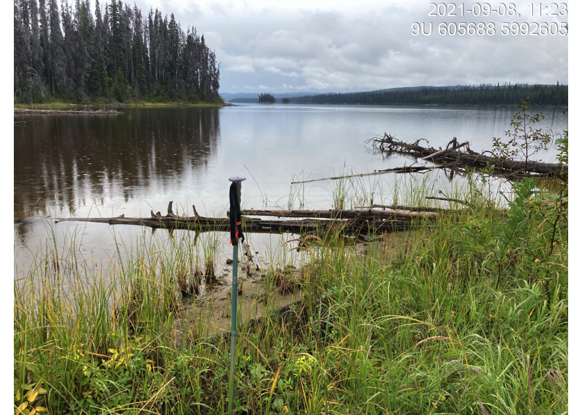
Figure 5.91: Typical habitat upstream of PSCIS crossing 198000.
my_caption <- paste0('Left: ', my_caption1, ' Right: ', my_caption2)

knitr::include_graphics(my_photo1)
knitr::include_graphics("fig/pixel.png")
knitr::include_graphics(my_photo2)