Corya Creek - 197960 - Appendix
Site Location
PSCIS crossing 197960 is located on Corya Creek within the Coryatsaqua 2 (Moricetown) Indian Reserve at Moricetown, BC. PSCIS crossing 197960 is located on CN Railway. Crossing 197960 was located 2.7km upstream from the confluence with the Bulkley River. Crossing 197960 is the responsibility of the Canadian National Railway.
Background
At crossing 197960, Corya Creek is a fourth order stream with a watershed area upstream of the crossing of approximately 65.7km2. The elevation of the watershed ranges from a maximum of 2502m to 410m near the crossing (Table 5.42). Upstream of crossing 197960, rainbow trout and dolly varden have previously been recorded (MoE 2020b; Norris 2020). PSCIS crossing 124612 is a bridge located 800m upstream at the powerline crossing and PSCIS crossing 123776 is a newly installed bridge downstream on Highway 16. Witset Creek drains Witset Lake and is a tributary to Corya Creek that flows in immediately downstream of the Highway 16 bridge. Witset Lake is 41ha in size with an associated 12ha of wetland. The upper Corya Creek watershed is glaciated and may provide habitat conditions most suitable for bull trout and cutthroat due to cold water and turbid conditions due to glacial flour. Although only rainbow trout and dolly varden have previously been recorded upstream of the railway, the historic culvert under Highway 16 and the current culvert under the railway may have hindered passage by other species including anadromous salmon.
In spring of 2017 a flood event caused by beaver dam failure forced the evacuation of homes in the Two Mile subdivision of Moricetown (Smithers Interior News 2017). Since this time beaver control activities have taken place in both the Corya and Witset watersheds to reduce the risk of flooding (pers comm. Dallas Nikal, Nico Ridge Consulting).
fpr::fpr_table_wshd_sum() %>%
  filter(Site == my_site | Site == my_site2) %>%
  fpr::fpr_kable(caption_text = paste0('Summary of derived upstream watershed statistics for PSCIS crossing ',
                                       my_site, 'and PSCIS crossing ', my_site2, '.'),
                 footnote_text = 'Elev P60 = Elevation at which 60% of the watershed area is above',
scroll = F)| Site | Area Km | Elev Site | Elev Min | Elev Max | Elev Median | Elev P60 | Aspect |
|---|---|---|---|---|---|---|---|
| 123775 | 4.1 | 406 | 478 | 1248 | 762 | 697 | E |
| 197960 | 65.7 | 415 | 410 | 2502 | 1260 | 1106 | ESE |
| * Elev P60 = Elevation at which 60% of the watershed area is above |
Corya Creek was ranked as a high priority for follow up by Irvine (2018) and Mazany-Wright et al. (2021) because of significant amounts of habitat modelled as upstream of the crossing. A summary of habitat modelling outputs is presented in Table 5.43. In the field, PSCIS stream crossing 123775 was also assessed as Witset Lake is located upstream. A map of the watershed is provided in map attachment 093M.102.
| Habitat | Potential | Remediation Gain | Remediation Gain (%) |
|---|---|---|---|
| ST Network (km) | 27.0 | 24.4 | 90 |
| ST Lake Reservoir (ha) | 0.0 | 0.0 | – |
| ST Wetland (ha) | 0.0 | 0.0 | – |
| ST Slopeclass03 Waterbodies (km) | 1.4 | 0.0 | 0 |
| ST Slopeclass03 (km) | 4.7 | 3.8 | 81 |
| ST Slopeclass05 (km) | 6.8 | 6.6 | 97 |
| ST Slopeclass08 (km) | 7.6 | 6.6 | 87 |
| ST Spawning (km) | 6.1 | 6.1 | 100 |
| ST Rearing (km) | 14.1 | 13.9 | 99 |
| CH Spawning (km) | 6.1 | 6.1 | 100 |
| CH Rearing (km) | 10.0 | 9.8 | 98 |
| CO Spawning (km) | 9.1 | 9.1 | 100 |
| CO Rearing (km) | 10.0 | 9.8 | 98 |
| CO Rearing (ha) | 0.0 | 0.0 | – |
| SK Spawning (km) | 0.0 | 0.0 | – |
| SK Rearing (km) | 0.0 | 0.0 | – |
| SK Rearing (ha) | – | 0.0 | – |
| All Spawning (km) | 9.1 | 9.1 | 100 |
| All Rearing (km) | 14.1 | 13.9 | 99 |
| All Spawning Rearing (km) | 14.1 | 13.9 | 99 |
| * Model data is preliminary and subject to adjustments. |
Stream Characteristics at Crossing
At the time of the survey, PSCIS crossing 197960 was un-embedded, non-backwatered and ranked as a barrier to upstream fish passage according to the provincial protocol (MoE 2011b) (Table 5.44). Water temperature was 8\(^\circ\)C, pH was 8.6 and conductivity was 138uS/cm.
At the time of the survey, PSCIS crossing 123775 was un-embedded, non-backwatered and ranked as a potential barrier to upstream fish passage according to the provincial protocol (MoE 2011b) (Table 5.45).
| Location and Stream Data |
|
Crossing Characteristics | – |
|---|---|---|---|
| Date | 2021-09-13 | Crossing Sub Type | Round Culvert |
| PSCIS ID | 197960 | Diameter (m) | 3.4 |
| External ID | – | Length (m) | 24 |
| Crew | AI KP | Embedded | No |
| UTM Zone | 9 | Depth Embedded (m) | – |
| Easting | 605785.6 | Resemble Channel | No |
| Northing | 6099884 | Backwatered | No |
| Stream | Corya Creek | Percent Backwatered | – |
| Road | CN Railway | Fill Depth (m) | 1.5 |
| Road Tenure | Canadian National | Outlet Drop (m) | 0.65 |
| Channel Width (m) | 18 | Outlet Pool Depth (m) | 3 |
| Stream Slope (%) | 2.8 | Inlet Drop | No |
| Beaver Activity | Yes | Slope (%) | 2.5 |
| Habitat Value | High | Valley Fill | Deep Fill |
| Final score | 34 | Barrier Result | Barrier |
| Fix type | Replace with New Open Bottom Structure | Fix Span / Diameter | 23 |
Photos: From top left clockwise: Road/Site Card, Barrel, Outlet, Downstream, Upstream, Inlet.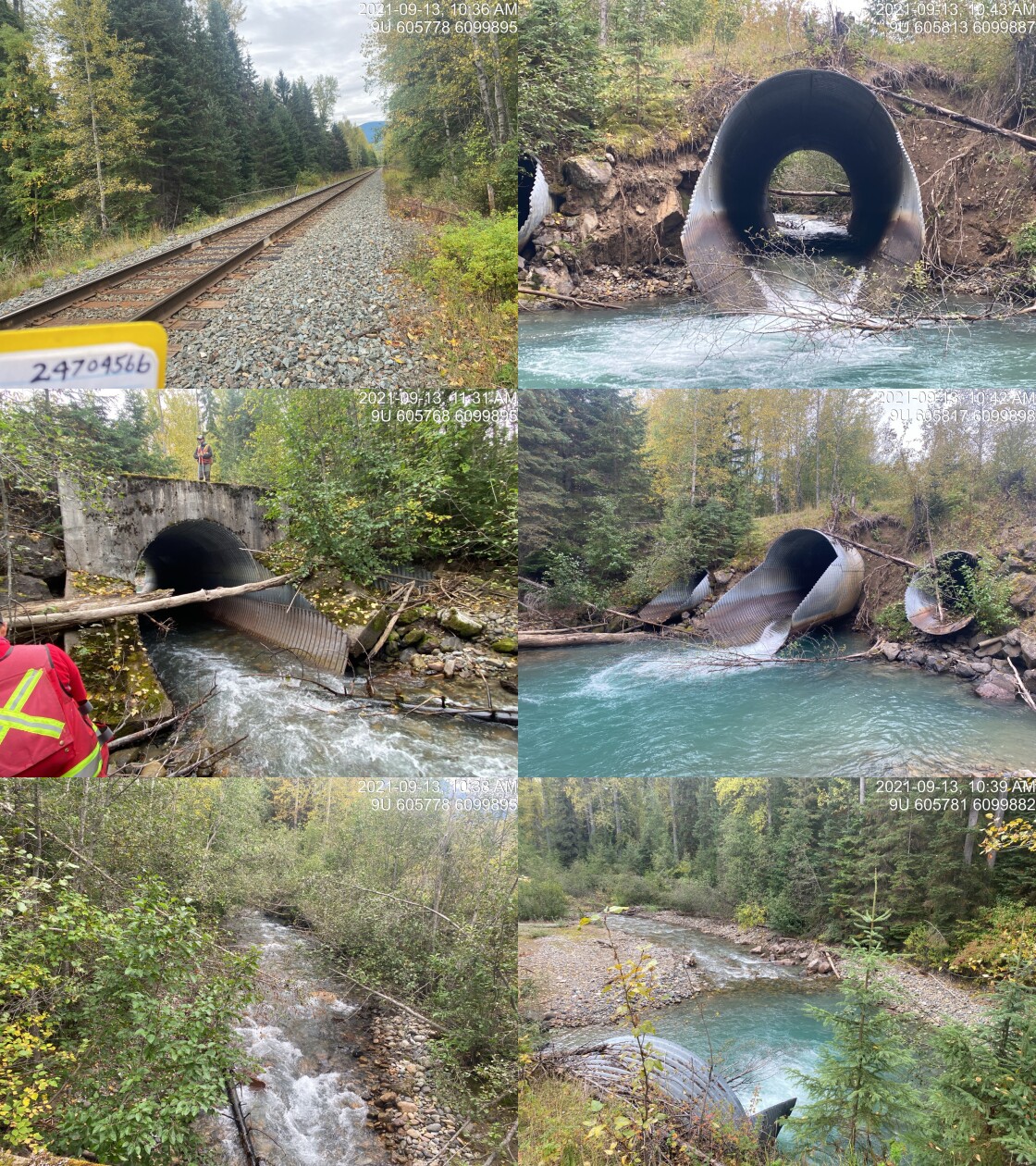
|
|||
| Comments: Outlet is cracked and drops. Inlet embedded to 2/3 way. 10:33 |
| Location and Stream Data |
|
Crossing Characteristics | – |
|---|---|---|---|
| Date | 2021-09-15 | Crossing Sub Type | Round Culvert |
| PSCIS ID | 123775 | Diameter (m) | 1.22 |
| External ID | – | Length (m) | 32 |
| Crew | DN AN | Embedded | No |
| UTM Zone | 9 | Depth Embedded (m) | – |
| Easting | 606445.5 | Resemble Channel | No |
| Northing | 6099726 | Backwatered | No |
| Stream | Witset Creek | Percent Backwatered | – |
| Road | Highway 16 | Fill Depth (m) | 0.3 |
| Road Tenure | MoTi Arterial | Outlet Drop (m) | 0 |
| Channel Width (m) | 0.5 | Outlet Pool Depth (m) | 0 |
| Stream Slope (%) | 1 | Inlet Drop | No |
| Beaver Activity | No | Slope (%) | 0.5 |
| Habitat Value | Low | Valley Fill | Deep Fill |
| Final score | 16 | Barrier Result | Potential |
| Fix type | Replace Structure with Streambed Simulation CBS | Fix Span / Diameter | 3 |
Photos: From top left clockwise: Road/Site Card, Barrel, Outlet, Downstream, Upstream, Inlet.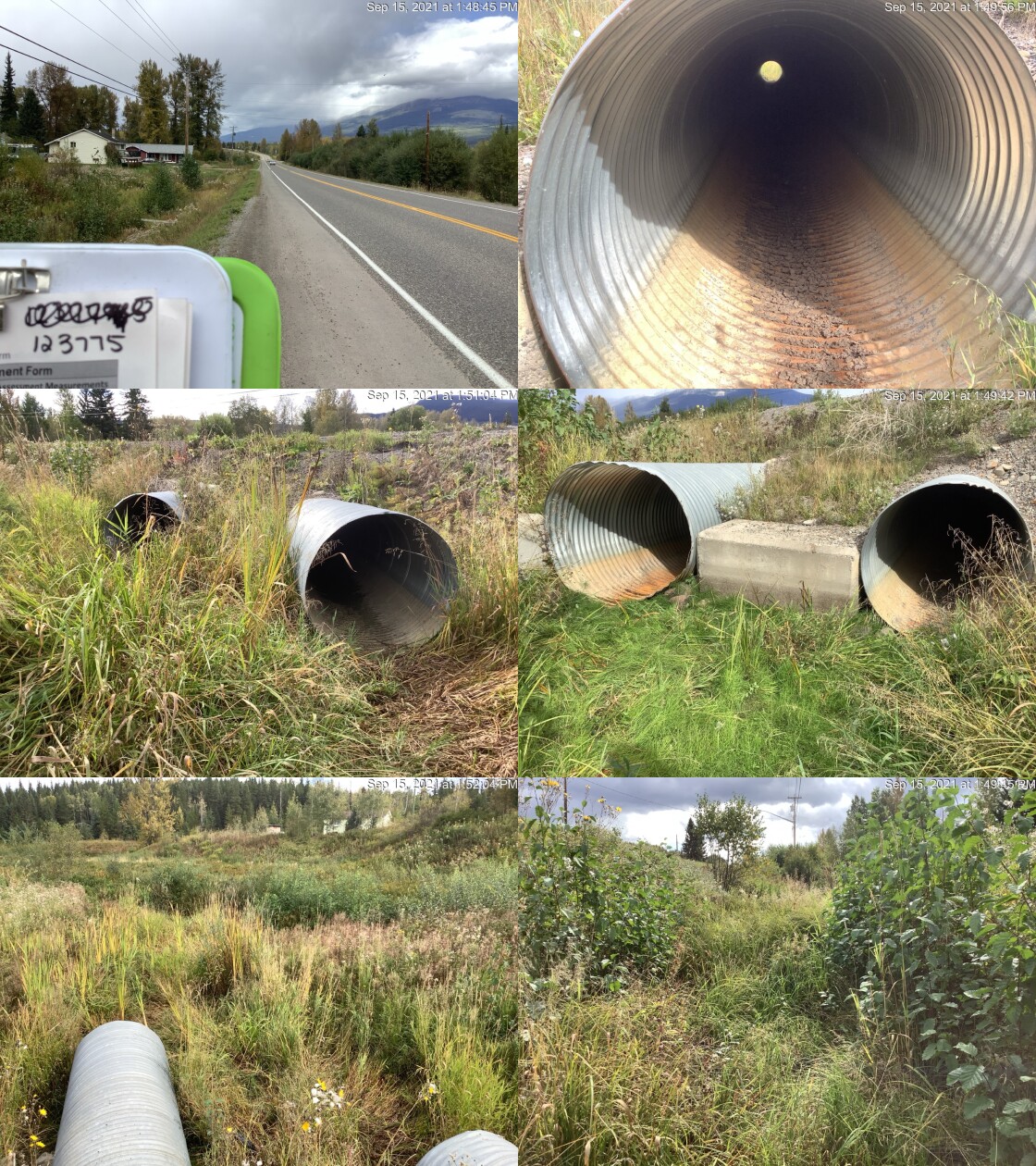
|
|||
| Comments: Round culvert. 13:30 |
Stream Characteristics Downstream of 197960
The stream was surveyed downstream from crossing 197960 for 450m (Figures 5.62 - 5.63). Total cover amount was rated as moderate with overhanging vegetation dominant. Cover was also present as small woody debris, large woody debris, undercut banks, and deep pools. The average channel width was 25.4m, the average wetted width was 8.9m and the average gradient was 1.7%. The dominant substrate was cobbles with gravels subdominant. The stream was moderately turbid due to glacial flour with abundant quantities of gravels suitably sized for trout and salmon species present. The stream channel was noted as riffle dominated with a lack of complexity due to adjacent riparian clearing and dyke installation. The habitat was rated as medium value for salmonid rearing and spawning.
Stream Characteristics Upstream of 197960
The stream was surveyed upstream from crossing 197960 for 1000m (Figures 5.64 - 5.65). Total cover amount was rated as moderate with overhanging vegetation dominant. Cover was also present as small woody debris, large woody debris, boulders, and undercut banks. The average channel width was 18m, the average wetted width was 8.9m and the average gradient was 2.8%. The dominant substrate was cobbles with gravels subdominant. The first 50 - 100m upstream of crossing channel and banks were noted as armoured with riprap. Abundant gravels suitable for resident and anadromous salmonids were noted throughout. The habitat was rated as medium value as an important migration corridor containing suitable spawning habitat and having moderate rearing potential.
Stream Characteristics Downstream of 123775
The stream was surveyed downstream from crossing 123775 for 100m . The average channel width was 0.5m and the average gradient was 1%. The channel was poorly defined, indicating flows were intermittently only. The habitat was rated as low value for salmonid rearing and spawning.
Stream Characteristics Upstream of 123775
The stream was surveyed upstream from crossing 123775 for 200m . Total cover amount was rated as moderate with overhanging vegetation dominant. Cover was also present as small woody debris, large woody debris, and instream vegetation. The average channel width was 2.4m, the average wetted width was 0.9m and the average gradient was 1.2%. The dominant substrate was gravels with fines subdominant. Water in channel was most likely from the previous rainfall. Beaver activity was present, the water level was extremely low and there was no flow. Witset maintenance actively traps beavers to prevent flood events as of 2017. The habitat was rated as low value for salmonid rearing and spawning.
Fish Sampling
To assess potential impacts of the culvert on fisheries values in the stream, electrofishing was conducted with results summarised in Tables 5.47 - 5.48 and Figure 5.61.
Structure Remediation and Cost Estimate
Should restoration/maintenance activities proceed, replacement of PSCIS crossing 197960 with a bridge (23m span) is recommended. The cost of the work is estimated at $13,800,000 for a cost benefit of 0.7 linear m/$1000 and 13 m2/$1000.
Conclusion
There was 10km of habitat upstream of crossing 197960 rated as medium value for salmonid rearing and spawning. Crossing 197960 was ranked as a high priority for proceeding to design for replacement. The stream is a cold water glaciated system and may currently provide habitat conditions most suitable for dolly varden and cutthrout trout.
Crossing 197960 was ranked as a low priority for remediation at the time of reporting due to low habitat value within the channel connecting Witset Lake to Corya Creek, upstream and downstream of crossing 123775. Beaver control activities within the watershed to reduce the risk of flooding in the Moricetown likely impacts flow patterns (shorter freshet and flashier flows following precipitation) and the subsequent habitat quality in Witset Creek. A watershed level plan to hold more water on the landscape upstream of the highway and increase the capacity of PSCIS crossing 197960 to pass higher flow events could be considered in the long term to increase the overall health of the watershed and improve the potential for connectivity between Corya Creek and Witset Lake.
tab_hab_summary %>%
  filter(Site  == my_site |
           Site == my_site2) %>%
  # select(-Site) %>%
  fpr::fpr_kable(caption_text = paste0('Summary of habitat details for PSCIS crossing ', my_site, ' and ', my_site2, '.'),
scroll = F) | Site | Location | Length Surveyed (m) | Channel Width (m) | Wetted Width (m) | Pool Depth (m) | Gradient (%) | Total Cover | Habitat Value |
|---|---|---|---|---|---|---|---|---|
| 123775 | Downstream | 100 | 0.5 | – | – | 1.0 | abundant | low |
| 123775 | Upstream | 200 | 2.4 | 0.9 | – | 1.2 | moderate | low |
| 197960 | Downstream | 450 | 25.4 | 10.8 | 0.5 | 1.7 | moderate | medium |
| 197960 | Upstream | 1000 | 18.0 | 8.9 | 0.7 | 2.8 | moderate | medium |
| site | passes | ef_length_m | ef_width_m | area_m2 | enclosure |
|---|---|---|---|---|---|
| 197960_ds_ef1 | 1 | 9.6 | 1.28 | 12.3 | Open |
| 197960_ds_ef2 | 1 | 5.0 | 1.83 | 9.2 | Open |
| 197960_ds_ef3 | 1 | 10.1 | 1.67 | 16.9 | Open |
| 197960_us_ef1 | 1 | 4.7 | 1.65 | 7.8 | Open |
| 197960_us_ef2 | 1 | 19.0 | 1.86 | 35.3 | Open |
| 197960_us_ef3 | 1 | 3.3 | 3.27 | 10.8 | Open |
| local_name | species_code | life_stage | catch | density_100m2 | nfc_pass |
|---|---|---|---|---|---|
| 197960_ds_ef1 | NFC | – | 0 | 0.0 | TRUE |
| 197960_ds_ef2 | DV | fry | 2 | 21.7 | FALSE |
| 197960_ds_ef2 | DV | parr | 2 | 21.7 | FALSE |
| 197960_ds_ef3 | DV | fry | 6 | 35.5 | FALSE |
| 197960_ds_ef3 | DV | parr | 1 | 5.9 | FALSE |
| 197960_us_ef1 | DV | parr | 1 | 12.8 | FALSE |
| 197960_us_ef2 | NFC | – | 0 | 0.0 | TRUE |
| 197960_us_ef3 | DV | parr | 1 | 9.3 | FALSE |
|
* nfc_pass FALSE means fish were captured in final pass indicating more fish of this species/lifestage may have remained in site. Mark-recaptured required to reduce uncertainties. |
my_caption <- paste0('Densites of fish (fish/100m2) capture upstream and downstream of PSCIS crossing ', my_site, '.')

fpr_plot_fish_box() 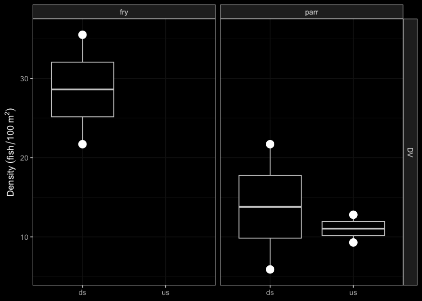
Figure 5.61: Densites of fish (fish/100m2) capture upstream and downstream of PSCIS crossing 197960.
my_photo1 = fpr::fpr_photo_pull_by_str(str_to_pull = '_d1_')

my_caption1 = paste0('Typical habitat downstream of PSCIS crossing ', my_site, '.')


# fpr::fpr_photo_flip(site_id = 1802488, str_to_pull = '6257')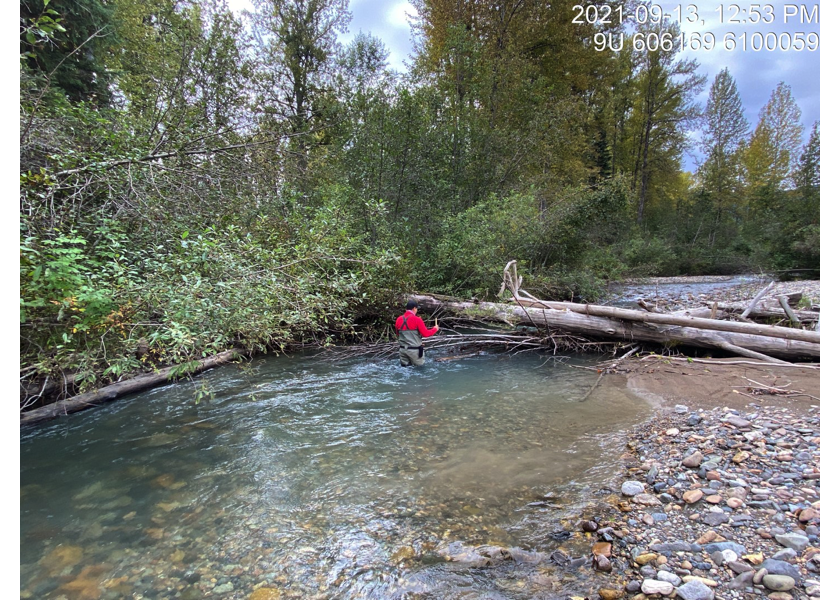
Figure 5.62: Typical habitat downstream of PSCIS crossing 197960.
my_photo2 = fpr::fpr_photo_pull_by_str(str_to_pull = '_d2_')

my_caption2 = paste0('Typical habitat downstream of PSCIS crossing ', my_site, '.')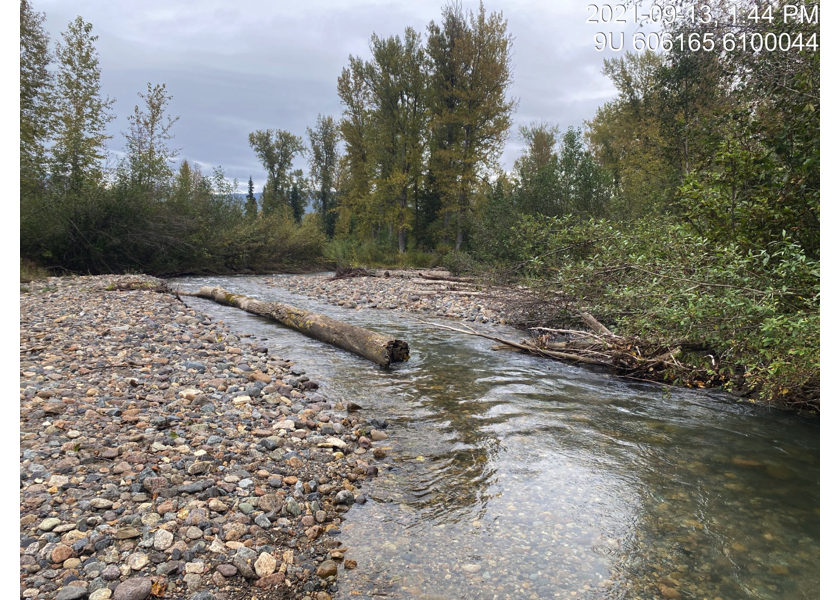
Figure 5.63: Typical habitat downstream of PSCIS crossing 197960.
my_caption <- paste0('Left: ', my_caption1, ' Right: ', my_caption2)

knitr::include_graphics(my_photo1)
knitr::include_graphics("fig/pixel.png")
knitr::include_graphics(my_photo2)
my_photo1 = fpr::fpr_photo_pull_by_str(str_to_pull = '_u1_')
my_caption1 = paste0('Typical habitat upstream of PSCIS crossing ', my_site, '.')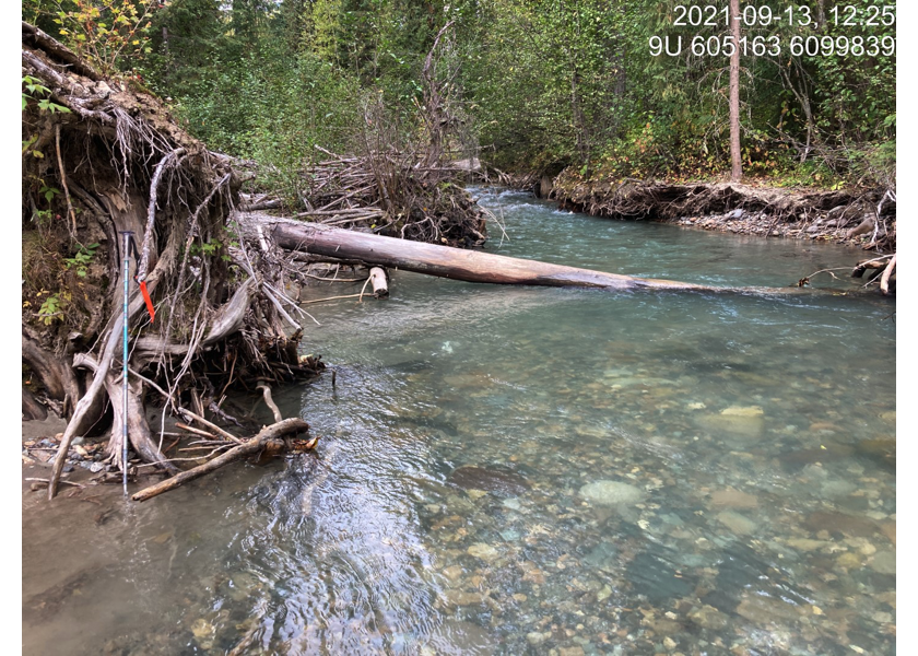
Figure 5.64: Typical habitat upstream of PSCIS crossing 197960.
my_photo2 = fpr::fpr_photo_pull_by_str(str_to_pull = '_u2_')

my_caption2 = paste0('Typical habitat upstream of PSCIS crossing ', my_site, '.')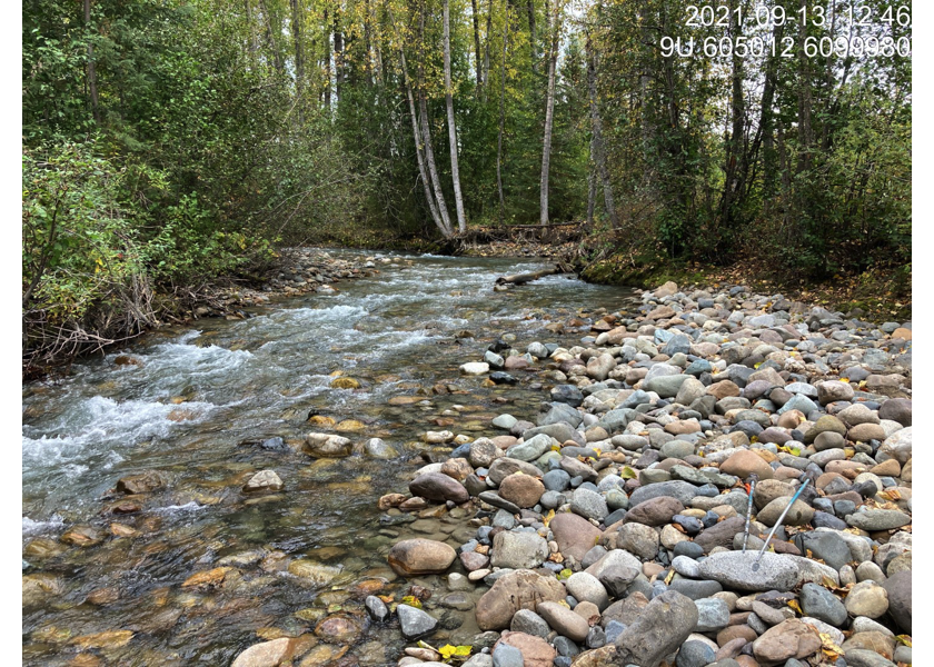
Figure 5.65: Typical habitat upstream of PSCIS crossing 197960.
my_caption <- paste0('Left: ', my_caption1, ' Right: ', my_caption2)

knitr::include_graphics(my_photo1)
knitr::include_graphics("fig/pixel.png")
knitr::include_graphics(my_photo2)