Taman Creek - 197967 - Appendix
Site Location
PSCIS crossing 197967 is located on the Upper Bulkley River approximately 22.5km east of Topley, BC. PSCIS crossing 197967 is located on Highway 16, approximately 2.5km upstream from Bulkley Lake. Although Taman Creek flows into this stream approximately 750m upstream of the highway, the stream at the highway is commonly referred to as Taman Creek including on highway signage. The culvert is the responsibility of the Ministry of Transportation and Infrastructure.
Background
At crossing 197967, the Upper Bulkey River is a fifth order stream with a watershed area upstream of the crossing of approximately 93.8km2. The elevation of the watershed ranges from a maximum of 1373m to 375m near the crossing (Table 5.55). Upstream of crossing 197967, longnose sucker, largescale sucker, lake chub, brassy minnow, northern pikeminnow, longnose dace, redside shiner, and rainbow trout have previously been recorded (MoE 2020b; Norris 2020).
fpr::fpr_table_wshd_sum(site_id = my_site) %>%
  fpr::fpr_kable(caption_text = paste0('Summary of derived upstream watershed statistics for PSCIS crossing ', my_site, '.'),
           footnote_text = 'Elev P60 = Elevation at which 60% of the watershed area is above',
scroll = F)| Site | Area Km | Elev Site | Elev Min | Elev Max | Elev Median | Elev P60 | Aspect |
|---|---|---|---|---|---|---|---|
| 197967 | 93.8 | 736 | 699 | 1373 | 900 | 870 | S |
| * Elev P60 = Elevation at which 60% of the watershed area is above |
although no records of the falls have yet been recorded in MoE (2020d), Redden and Jedrzejczyk (1997) report that a 15m high rock falls is located at 7.8km upstream from the confluence with the upper Bulkley River and represents the upstream limit of fish distribution in the watershed. They also report excellent and good rearing potential in upper reaches of the stream located from 5.1km to 7.8km upstream of the confluence.
McCarthy and Fernando (2015) report that the culvert has received past efforts to facilitate backwatering including rock lines to establish backwater pools downstream of the culvert. They also report that the works were not functioning correctly. Smith (2018) visited the site in 2017, subjectively rated the crossing as a potential barrier and ranked the crossing as a low priority for follow up. Irvine (2021) noted that a design was being drafted for the Highway 16 crossing by Ministry of Transportation and Infrastructure in 2021.
PSCIS stream crossing 197967 was ranked as a high priority for follow up by Mazany-Wright et al. (2021) because of significant amounts of habitat modelled as upstream of the crossing and because gathering of habitat confirmation information was considered as potentially beneficial for informing prioritization of the site should remediation plans stall. A total of 172ha of lake and 695ha of wetland is modelled upstream and a summary of habitat modelling outputs is presented in Table 5.56. A map of the watershed is provided in map attachment 093L.115.
| Habitat | Potential | Remediation Gain | Remediation Gain (%) |
|---|---|---|---|
| ST Network (km) | 142.4 | 20.0 | 14 |
| ST Lake Reservoir (ha) | 172.4 | 98.7 | 57 |
| ST Wetland (ha) | 631.7 | 208.8 | 33 |
| ST Slopeclass03 Waterbodies (km) | 34.5 | 0.0 | 0 |
| ST Slopeclass03 (km) | 30.7 | 7.2 | 23 |
| ST Slopeclass05 (km) | 36.9 | 2.1 | 6 |
| ST Slopeclass08 (km) | 26.2 | 0.0 | 0 |
| ST Spawning (km) | 7.2 | 6.0 | 83 |
| ST Rearing (km) | 35.8 | 7.9 | 22 |
| CH Spawning (km) | 7.2 | 6.0 | 83 |
| CH Rearing (km) | 10.9 | 6.0 | 55 |
| CO Spawning (km) | 22.2 | 7.4 | 33 |
| CO Rearing (km) | 51.9 | 14.6 | 28 |
| CO Rearing (ha) | 285.7 | 0.0 | 0 |
| SK Spawning (km) | 0.0 | 0.0 | – |
| SK Rearing (km) | 0.0 | 0.0 | – |
| SK Rearing (ha) | – | 0.0 | – |
| All Spawning (km) | 22.2 | 7.4 | 33 |
| All Rearing (km) | 58.0 | 14.6 | 25 |
| All Spawning Rearing (km) | 58.0 | 14.6 | 25 |
| * Model data is preliminary and subject to adjustments. |
Stream Characteristics at Crossing
At the time of the survey, PSCIS crossing 197967 was non-backwatered and ranked as a barrier to upstream fish passage according to the provincial protocol (MoE 2011b) (Table 5.57). Water temperature was 12\(^\circ\)C, pH was 7.2 and conductivity was 359uS/cm. A beaver dam was noted just upstream of the culvert inlet (~1.5m high).
| Location and Stream Data |
|
Crossing Characteristics | – |
|---|---|---|---|
| Date | 2021-08-31 | Crossing Sub Type | Round Culvert |
| PSCIS ID | 197967 | Diameter (m) | 3 |
| External ID | – | Length (m) | 30 |
| Crew | KP AI | Embedded | No |
| UTM Zone | 9 | Depth Embedded (m) | – |
| Easting | 692434.6 | Resemble Channel | No |
| Northing | 6032331 | Backwatered | No |
| Stream | Taman Creek | Percent Backwatered | – |
| Road | Highway 16 | Fill Depth (m) | 9.99 |
| Road Tenure | Highway | Outlet Drop (m) | 0 |
| Channel Width (m) | 5.3 | Outlet Pool Depth (m) | 0.4 |
| Stream Slope (%) | 1.7 | Inlet Drop | Yes |
| Beaver Activity | Yes | Slope (%) | 2.5 |
| Habitat Value | Medium | Valley Fill | Deep Fill |
| Final score | 27 | Barrier Result | Barrier |
| Fix type | Replace with New Open Bottom Structure | Fix Span / Diameter | 31 |
Photos: From top left clockwise: Road/Site Card, Barrel, Outlet, Downstream, Upstream, Inlet.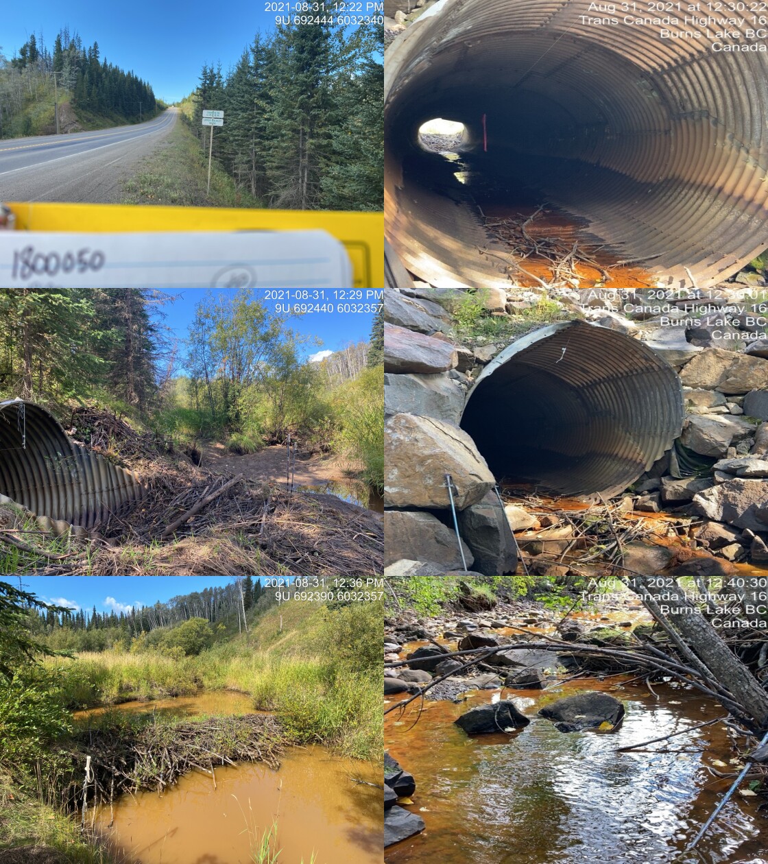
|
|||
| Comments: Beaver dam at inlet ~1.5m high. Rocks placed at outlet reducing drop to 0, rocks about long, and have stagged drop of 0.7m. 12:20 |
Stream Characteristics Downstream
The stream was surveyed downstream from crossing 197967 for 375m to the bridge (PSCIS 197966) located on Ross Lake Cutoff Rd (Figures 5.73 - 5.74). The average channel width was 5.7m, the average wetted width was 3.1m, and the average gradient was 2.5%.The dominant substrate was cobbles with fines sub-dominant.Total cover amount was rated as trace with overhanging vegetation dominant. Cover was also present as deep pools and instream vegetation. The site was noted as having significant amounts of thick red colored algae for the majority of survey. Flow was very low with uncommon pools. Fence material was noted in or across channel in two locations and and riparian vegetation had been removed where an agricultural field and fence line were close. Although considered an important migration corridor, the habitat was rated as medium value for salmonid rearing and spawning due to limited complexity resulting from adjacent agricultural activities.
PSCIS crossing 197964 is located on the CN Railway approximately 1.7km downstream of the highway. Although the crossing was assessed as a potential barrier according to the provincial protocol it was 100% backwatered at the time of the assessment and appeared passable to all species and life stages at the time of assessment (Table 5.58).
fpr::fpr_table_cv_summary_memo(dat = pscis_phase1, site = 1805529, site_photo_id = 1805529, col_filter = my_crossing_reference)| Location and Stream Data |
|
Crossing Characteristics | – |
|---|---|---|---|
| Date | 2021-08-31 | Crossing Sub Type | Round Culvert |
| PSCIS ID | – | Diameter (m) | 1.5 |
| External ID | 1805529 | Length (m) | 21 |
| Crew | KP AI | Embedded | No |
| UTM Zone | 9 | Depth Embedded (m) | – |
| Easting | 691218.3 | Resemble Channel | No |
| Northing | 6031478 | Backwatered | Yes |
| Stream | Bulkley River | Percent Backwatered | 100 |
| Road | Railway | Fill Depth (m) | 3 |
| Road Tenure | Canadian National | Outlet Drop (m) | 0 |
| Channel Width (m) | 9 | Outlet Pool Depth (m) | 0.8 |
| Stream Slope (%) | 0 | Inlet Drop | No |
| Beaver Activity | No | Slope (%) | 0.7 |
| Habitat Value | High | Valley Fill | Deep Fill |
| Final score | 19 | Barrier Result | Potential |
| Fix type | Replace with New Open Bottom Structure | Fix Span / Diameter | 14 |
Photos: From top left clockwise: Road/Site Card, Barrel, Outlet, Downstream, Upstream, Inlet.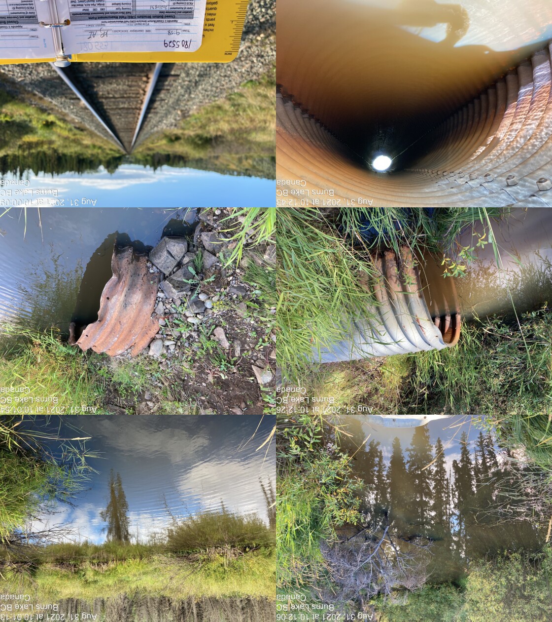
|
|||
| Comments: Backwatered fully, appears fully passable. Fish sighted at outlet. Distance from water surface to top of culvert is 70cm. 9:58 |
Stream Characteristics Upstream
The stream was surveyed upstream from crossing 197967 for 800m (Figures 5.75 - 5.76). The average channel width was 5.3m, the average wetted width was 2.3m, and the average gradient was 1.7%.The dominant substrate was gravels with cobbles sub-dominant.Total cover amount was rated as moderate with deep pools dominant. Cover was also present as large woody debris and overhanging vegetation. The first ~250m of channel upstream of the highway were noted as beaver influenced wetland with extensive dry sections at the time of the survey. Frequent pockets of gravels and small cobbles suitable for rainbow trout and coho salmon spawning were noted throughout the area surveyed. A canyon section of stream was located upstream of the crossing approximately 300m contained deep bedrock pools with small fish present and no large woody debris. One deep pool upstream of the canyon section contained likely 2-3 year old juveniles (coloring indicated rainbow trout, unverified). The habitat was rated as medium value as an important migration corridor containing suitable spawning habitat and having moderate rearing potential.
Taman Creek was surveyed for 400m above where it joins the Bulkley River mainstem upstream of PSCIS crossing 197967 (Figures 5.77 - 5.78). The dominant substrate was gravels with cobbles sub-dominant.The average channel width was 3.8m, the average wetted width was 2.2m, and the average gradient was 1.5%.Total cover amount was rated as moderate with deep pools dominant. Cover was also present as small woody debris, large woody debris, undercut banks, and overhanging vegetation. The water in Taman Creek during the survey was noted as turbid with numerous samlonid fry present at the downstream end of the site. Algae was abundant throughout the system and eroding banks were common. Abundant gravels suitable for resident rainbow trout and coho salmon spawning were present and habitat was rated as medium value for salmon rearing and spawning.
The upper Bulkley River was surveyed at numerous crossings upstream of the highway with bridges noted at PSCIS crossings 197968, 197969, 197973 and 197971. Survey crews were not able to access crossing 1802047 from Highway 16 due to a gate and private land postings. This crossing is located between Broman Lake and Old Woman Lake with public access potentially possible by ATV from the powerline to the north. Modelled crossing 1802663 is located on the mainstem of Taman Creek 1.8km upstream of the confluence with the upper Bulkley River. Although this site was not assessed it was considered likely to be a ford due to its location on the powerline. Numerous other unassessed crossings are modelled as located upstream within the system on Taman Creek as well as the upper Bulkley River and their tributaries. As the effort required to assess all these crossings was likely significant with the majority of higher value gains most likely present in the lower reaches, field time was allocated elsewhere in the greater Bulkley River watershed.
Structure Remediation and Cost Estimate
Should restoration/maintenance activities proceed, replacement of PSCIS crossing 197967 with a bridge (31m span) is recommended. The cost of the work is estimated at $18,600,000 for a cost benefit of 2.8 linear m/$1000 and 14.8 m2/$1000.
Conclusion
There was 51.9km of habitat modelled upstream of crossing 197967 rated as medium value for salmonid rearing and spawning. Crossing 197967 was ranked as a moderate priority for proceeding to design for replacement. At the time of reporting, the Ministry of transportation and Infrastructure were in the process of planning for crossing replacement. Of note, due to budgetary constraints, survey plans for the site call for horizontal drilling of a closed bottom structure under the highway with costs likley lower than those estimated for replacement with a clear span bridge. Should structure replacement proceed follow up monitoring is recomended to assess passability and utilization of the crossing by downstream fish populations including coho who have been recorded in the upper Bulkley River within 100m downstream of crossing 197967.
tab_hab_summary %>%
  filter(Site  == my_site) %>%
  # select(-Site) %>%
  fpr::fpr_kable(caption_text = paste0('Summary of habitat details for PSCIS crossing ', my_site, '.'),
scroll = F) | Site | Location | Length Surveyed (m) | Channel Width (m) | Wetted Width (m) | Pool Depth (m) | Gradient (%) | Total Cover | Habitat Value |
|---|---|---|---|---|---|---|---|---|
| 197967 | Downstream | 375 | 5.7 | 3.1 | 0.5 | 2.5 | trace | medium |
| 197967 | Upstream | 800 | 5.3 | 2.3 | 0.7 | 1.7 | moderate | medium |
| 197967 | Upstream2 | 400 | 3.8 | 2.2 | 0.5 | 1.5 | moderate | medium |
my_photo1 = fpr::fpr_photo_pull_by_str(str_to_pull = '_d1_')

my_caption1 = paste0('Habitat downstream of PSCIS crossing ', my_site, '.')


# fpr::fpr_photo_flip(site_id = 1802488, str_to_pull = '6257')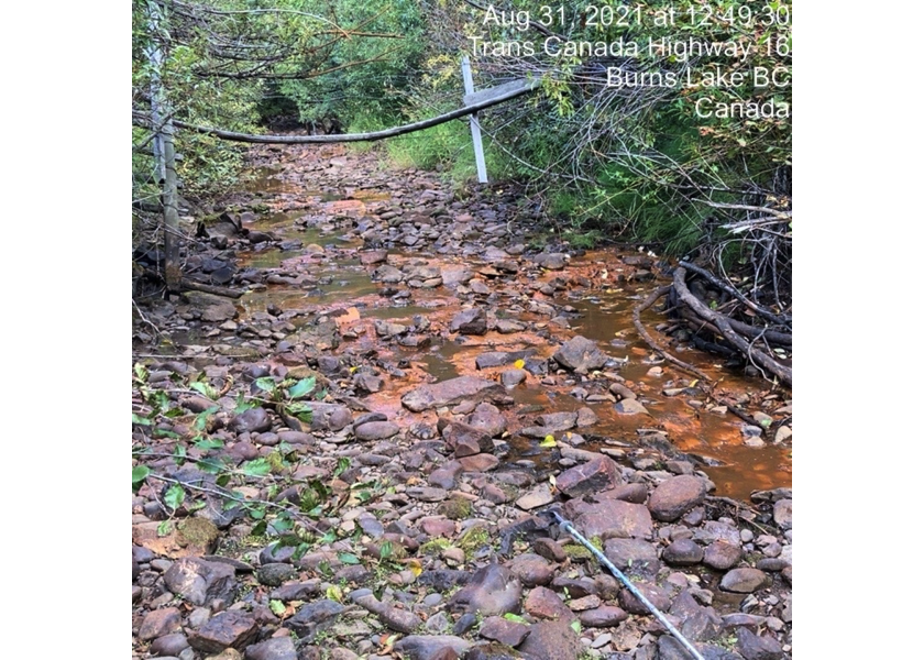
Figure 5.73: Habitat downstream of PSCIS crossing 197967.
my_photo2 = fpr::fpr_photo_pull_by_str(str_to_pull = '_d2_')

my_caption2 = paste0('Habitat downstream of PSCIS crossing ', my_site, '.')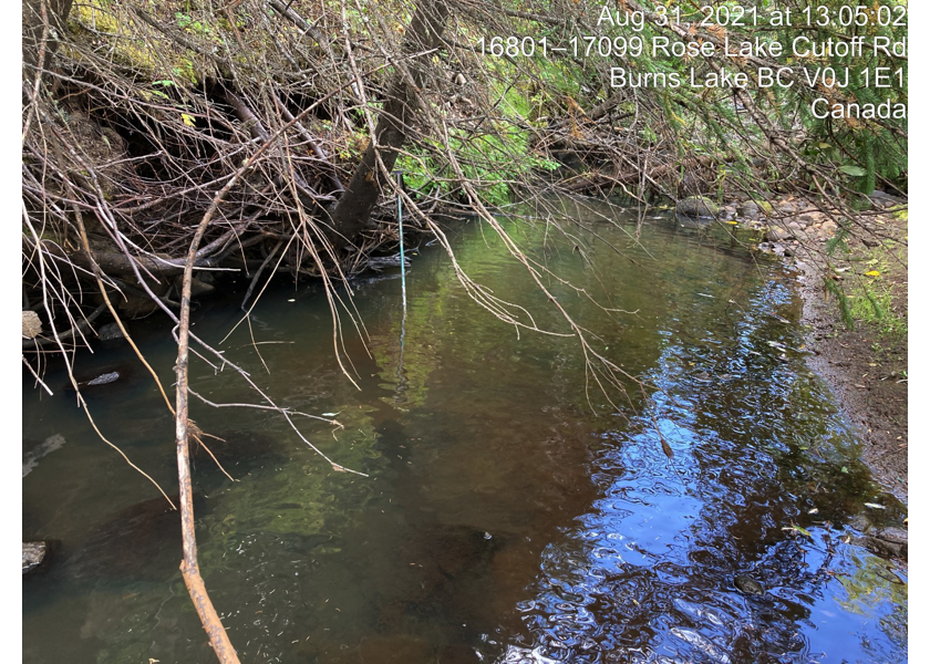
Figure 5.74: Habitat downstream of PSCIS crossing 197967.
my_caption <- paste0('Left: ', my_caption1, ' Right: ', my_caption2)

knitr::include_graphics(my_photo1)
knitr::include_graphics("fig/pixel.png")
knitr::include_graphics(my_photo2)
my_photo1 = fpr::fpr_photo_pull_by_str(str_to_pull = '_u1_')
my_caption1 = paste0('Habitat upstream of PSCIS crossing ', my_site, '.')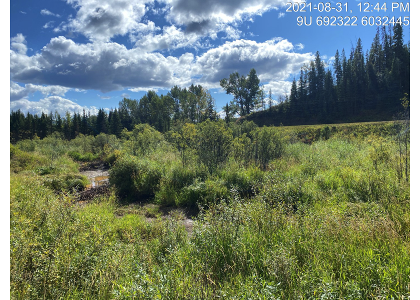
Figure 5.75: Habitat upstream of PSCIS crossing 197967.
my_photo2 = fpr::fpr_photo_pull_by_str(str_to_pull = '_u2_')

my_caption2 = paste0('Habitat upstream of PSCIS crossing ', my_site, '.')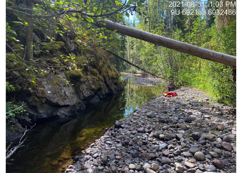
Figure 5.76: Habitat upstream of PSCIS crossing 197967.
my_caption <- paste0('Left: ', my_caption1, ' Right: ', my_caption2)

knitr::include_graphics(my_photo1)
knitr::include_graphics("fig/pixel.png")
knitr::include_graphics(my_photo2)
my_photo1 = fpr::fpr_photo_pull_by_str(str_to_pull = '_u3_')
my_caption1 = paste0('Habitat upstream of PSCIS crossing ', my_site, '.')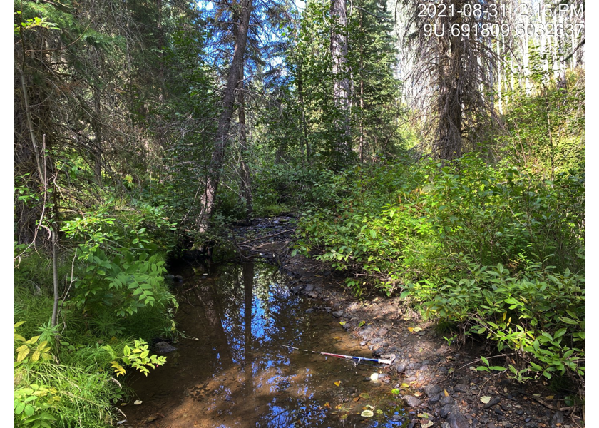
Figure 5.77: Habitat upstream of PSCIS crossing 197967.
my_photo2 = fpr::fpr_photo_pull_by_str(str_to_pull = '_u4_')

my_caption2 = paste0('Habitat upstream of PSCIS crossing ', my_site, '.')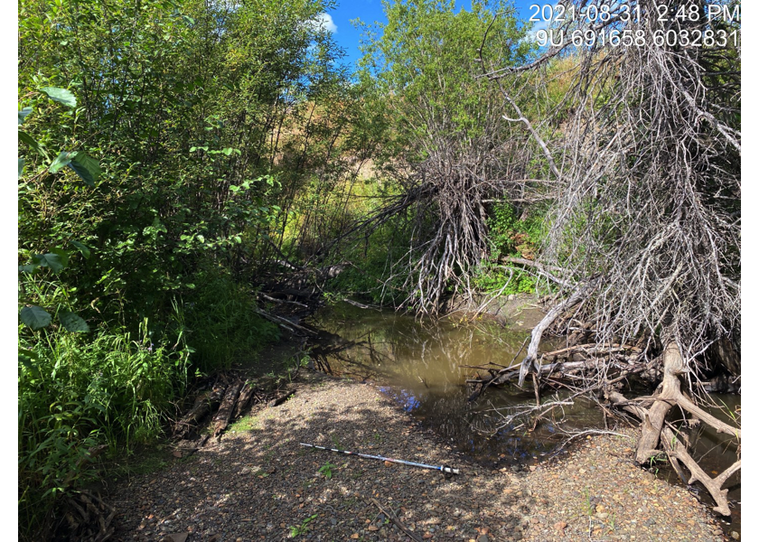
Figure 5.78: Habitat upstream of PSCIS crossing 197967.
my_caption <- paste0('Left: ', my_caption1, ' Right: ', my_caption2)

knitr::include_graphics(my_photo1)
knitr::include_graphics("fig/pixel.png")
knitr::include_graphics(my_photo2)