Cesford Creek - 198048 & 198049 - Appendix
Site Location
PSCIS crossing 198048 and 198049 are located on Cesford Creek near Topley, BC. PSCIS crossing 198048 is located on Highway 16 and 198049 is located on Highway 118. Crossing 198048 was located 0.6km upstream from the confluence with the Bulkley River and 198049 was located 1.3km upstream of the confluence. Crossings 198048 and 198049 are the responsibility of the Ministry of Transportation and Infrastructure. PSCIS crossing 198090 makes reference to a potential crossing location under the CN Railway. The survey team was not able to locate a crossing in the field which coincides with personal communications with the adjacent landowner (Figure 5.104).
Background
At crossing 198048, Cesford Creek is a fourth order stream with a watershed area upstream of the crossing of approximately 36.6km2. The elevation of the watershed ranges from a maximum of 1543m to 659m near the crossing (Table 5.79). Upstream of crossing 198048, rainbow trout have previously been recorded (MoE 2020b; Norris 2020).
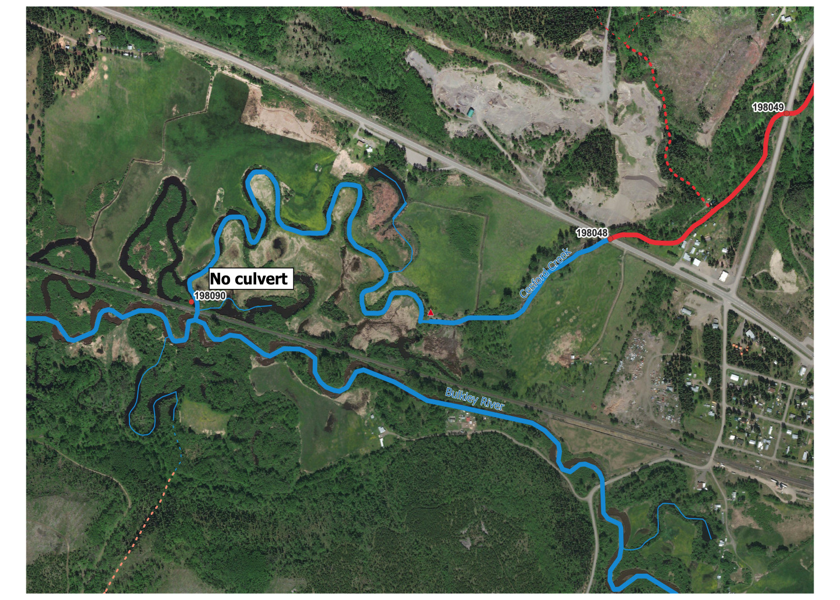
Figure 5.104: Location of potential location of crossing 198090 which was not present in the field.
fpr::fpr_table_wshd_sum(site_id = my_site) %>%
  fpr::fpr_kable(caption_text = paste0('Summary of derived upstream watershed statistics for PSCIS crossing ', my_site, '.'),
           footnote_text = 'Elev P60 = Elevation at which 60% of the watershed area is above',
scroll = F)| Site | Area Km | Elev Site | Elev Min | Elev Max | Elev Median | Elev P60 | Aspect |
|---|---|---|---|---|---|---|---|
| 198048 | 36.6 | 679 | 659 | 1543 | 935 | 914 | SSW |
| * Elev P60 = Elevation at which 60% of the watershed area is above |
PSCIS stream crossing 198048 was ranked as a priority for follow up by Irvine (2021) because of the relatively large size of the stream and the potential for large amounts of habitat gains through fish passage remediation (Table 5.80. Although Wilson and Rabnett (2007) recommended establishing a downstream weir and excavating adequate outfall drop pools to facilitate fish passage at crossing 198048, they ranked the site as a moderate priority for remediation due to dewatering below Highway 16. Smith (2018) assessed the site in 2017 and noted that a comparison of photos taken in 2006 and 2017 indicates that a significant amount of gravel has been deposited in the channel below the culvert outlets.
Upon review of aerial imagery, it appears that a large portion of the historical paths of Cesford Creek are located with the floodplain of the Bulkley River with extensive impacts apparent due to land clearing and the installation of the railway. The railway in this section of the upper Bulkley River bisects numerous historical meanders blocking access to extensive areas of likely very high value low velocity salmon rearing habitat. In addition there also appears to be ditching within these lands used for agriculture that although unconfirmed, may function to lower the water table in the floodplain, reducing productivity exacerbating seasonal dewatering. A map of the watershed is provided in map attachment 093L.115.
| Habitat | Potential | Remediation Gain | Remediation Gain (%) |
|---|---|---|---|
| ST Network (km) | 54.4 | 1.0 | 2 |
| ST Lake Reservoir (ha) | 26.4 | 0.0 | 0 |
| ST Wetland (ha) | 24.0 | 0.0 | 0 |
| ST Slopeclass03 Waterbodies (km) | 3.4 | 0.0 | 0 |
| ST Slopeclass03 (km) | 4.9 | 0.7 | 14 |
| ST Slopeclass05 (km) | 20.8 | 0.0 | 0 |
| ST Slopeclass08 (km) | 14.0 | 0.3 | 2 |
| ST Spawning (km) | 1.8 | 0.7 | 39 |
| ST Rearing (km) | 15.9 | 1.0 | 6 |
| CH Spawning (km) | 1.7 | 0.7 | 41 |
| CH Rearing (km) | 4.5 | 0.7 | 16 |
| CO Spawning (km) | 6.1 | 0.7 | 11 |
| CO Rearing (km) | 10.7 | 0.7 | 7 |
| CO Rearing (ha) | – | 0.0 | – |
| SK Spawning (km) | 0.0 | 0.0 | – |
| SK Rearing (km) | 0.0 | 0.0 | – |
| SK Rearing (ha) | – | 0.0 | – |
| All Spawning (km) | 6.2 | 0.7 | 11 |
| All Rearing (km) | 15.9 | 1.0 | 6 |
| All Spawning Rearing (km) | 15.9 | 1.0 | 6 |
| * Model data is preliminary and subject to adjustments. |
Stream Characteristics at Crossing
At the time of the survey, PSCIS crossing 198048 was un-embedded, non-backwatered and ranked as a barrier barrier to upstream fish passage according to the provincial protocol 5.81">MoE (2011b). Water temperature was 11\(^\circ\)C, pH was 8.2 and conductivity was 263uS/cm.
| Location and Stream Data |
|
Crossing Characteristics | – |
|---|---|---|---|
| Date | 2021-09-05 | Crossing Sub Type | Round Culvert |
| PSCIS ID | 198048 | Diameter (m) | 2.5 |
| External ID | – | Length (m) | 25 |
| Crew | AI | Embedded | No |
| UTM Zone | 9 | Depth Embedded (m) | – |
| Easting | 674397.1 | Resemble Channel | No |
| Northing | 6043433 | Backwatered | Yes |
| Stream | Cesford Creek | Percent Backwatered | 30 |
| Road | Highway 16 | Fill Depth (m) | 1 |
| Road Tenure | MoTi Arterial | Outlet Drop (m) | 0 |
| Channel Width (m) | 5.48 | Outlet Pool Depth (m) | 0.09 |
| Stream Slope (%) | 3.5 | Inlet Drop | Yes |
| Beaver Activity | No | Slope (%) | 1.5 |
| Habitat Value | High | Valley Fill | Deep Fill |
| Final score | 24 | Barrier Result | Barrier |
| Fix type | Replace with New Open Bottom Structure | Fix Span / Diameter | 10 |
Photos: From top left clockwise: Road/Site Card, Barrel, Outlet, Downstream, Upstream, Inlet.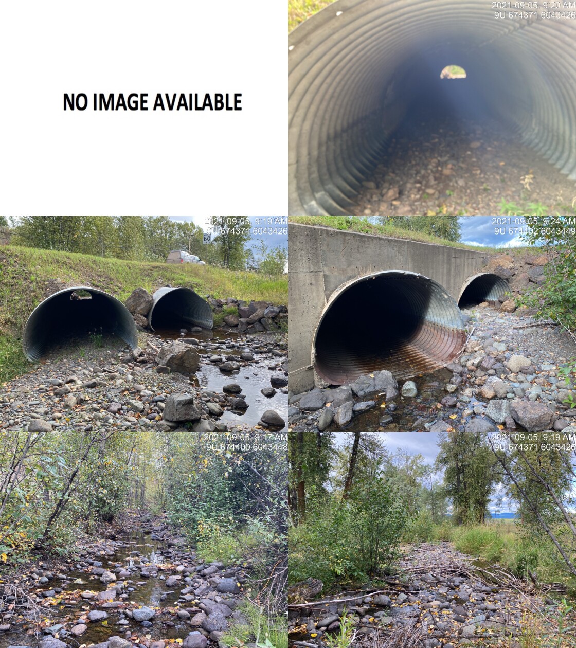
|
|||
| Comments: Habitat confirmation conducted. Two pipes (2.5m x 2.5m). Culvert slope measured with lazel level. Fish observed. Could not locate downstream crossing on railway. Garmin backroads mapbook shows stream connecting with side channel of the Bulkley. 9:17 |
| Location and Stream Data |
|
Crossing Characteristics | – |
|---|---|---|---|
| Date | 2021-09-05 | Crossing Sub Type | Round Culvert |
| PSCIS ID | 198049 | Diameter (m) | 3.7 |
| External ID | – | Length (m) | 21 |
| Crew | AI | Embedded | No |
| UTM Zone | 9 | Depth Embedded (m) | – |
| Easting | 674875.4 | Resemble Channel | No |
| Northing | 6043782 | Backwatered | No |
| Stream | Cesford Creek | Percent Backwatered | – |
| Road | Highway 118 | Fill Depth (m) | 1 |
| Road Tenure | MoTi Arterial | Outlet Drop (m) | 0.5 |
| Channel Width (m) | 4.9 | Outlet Pool Depth (m) | 0.25 |
| Stream Slope (%) | 2.83 | Inlet Drop | No |
| Beaver Activity | No | Slope (%) | 1.5 |
| Habitat Value | High | Valley Fill | Deep Fill |
| Final score | 34 | Barrier Result | Barrier |
| Fix type | Replace with New Open Bottom Structure | Fix Span / Diameter | 10 |
Photos: From top left clockwise: Road/Site Card, Barrel, Outlet, Downstream, Upstream, Inlet.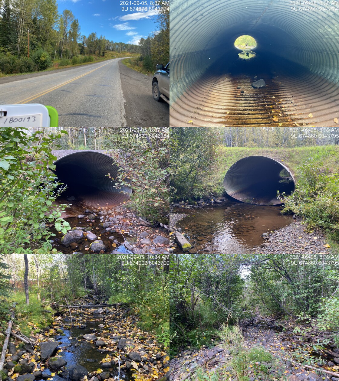
|
|||
| Comments: Habitat confirmation conducted. ~110mm fish observed in outlet pool. Culvert slope surveyed with lazer level. 8:37 |
| Location and Stream Data |
|
Crossing Characteristics | – |
|---|---|---|---|
| Date | 2021-09-05 | Crossing Sub Type | Round Culvert |
| PSCIS ID | 198090 | Diameter (m) | 0.1 |
| External ID | – | Length (m) | 15 |
| Crew | KP | Embedded | No |
| UTM Zone | 9 | Depth Embedded (m) | – |
| Easting | 673235 | Resemble Channel | No |
| Northing | 6043218 | Backwatered | No |
| Stream | Cesford Creek | Percent Backwatered | – |
| Road | CN Railway | Fill Depth (m) | 2 |
| Road Tenure | Canadian National | Outlet Drop (m) | 0 |
| Channel Width (m) | 5 | Outlet Pool Depth (m) | 0 |
| Stream Slope (%) | 1 | Inlet Drop | No |
| Beaver Activity | No | Slope (%) | 3 |
| Habitat Value | High | Valley Fill | Deep Fill |
| Final score | 29 | Barrier Result | Barrier |
| Fix type | Replace with New Open Bottom Structure | Fix Span / Diameter | 10 |
Photos: From top left clockwise: Road/Site Card, Barrel, Outlet, Downstream, Upstream, Inlet.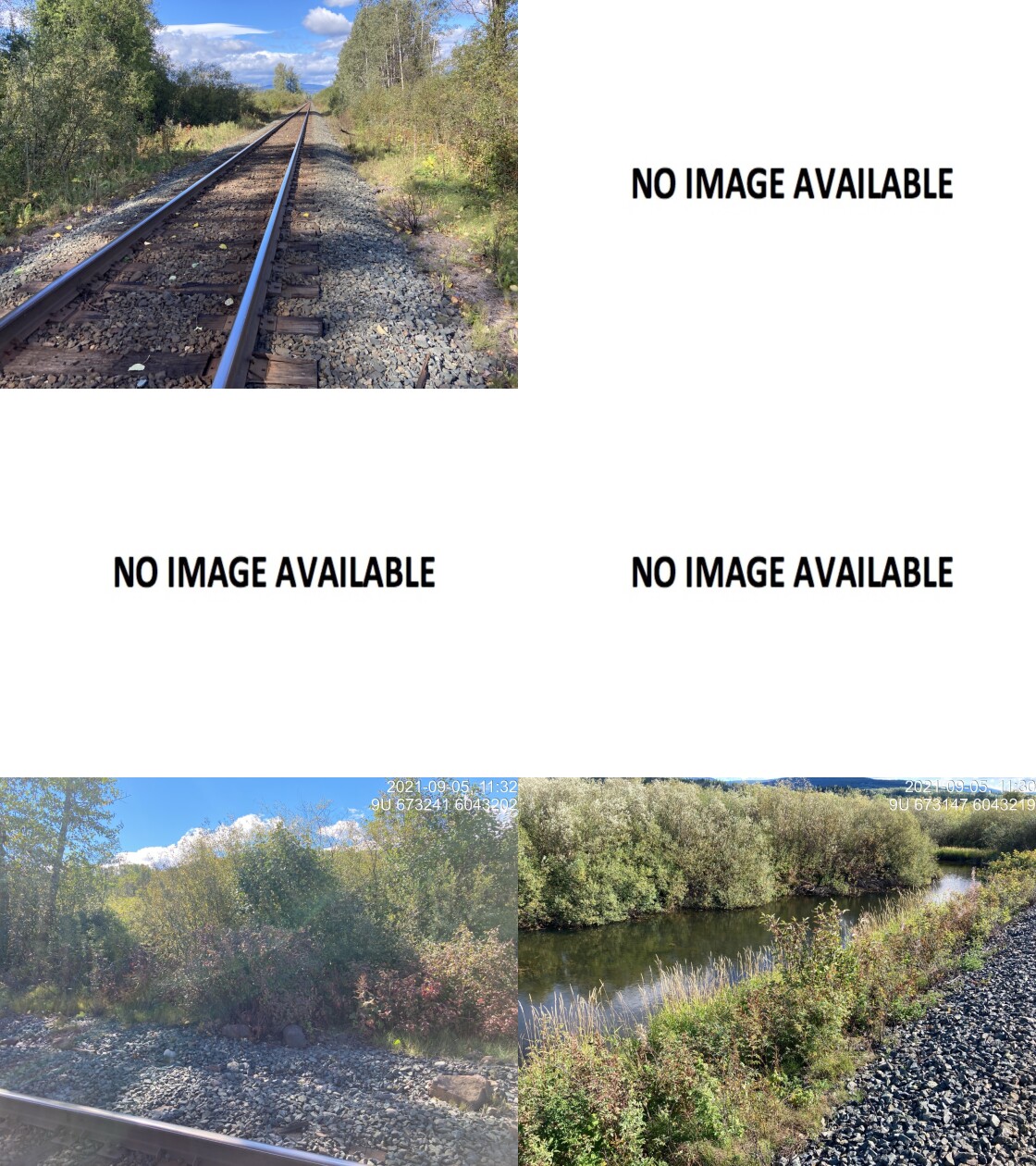
|
|||
| Comments: No crossing actually exists in the field however site entered as a placeholder because there should be connection between Bulkley and Cesford at this location. Survey found no culvert and landowner reported none present. Large man-made ditch through adjacent field may be draining some water. Lower section of stream dry at time of survey. 11:22 |
Stream Characteristics Downstream
The stream was surveyed downstream from crossing 198048 at Highway 16 for 1400m to the mainstem of the Bulkley River (Figures 5.105 - 5.106). Total cover amount was rated as with overhanging vegetation dominant. Cover was also present as small woody debris and undercut banks (Table 5.84). The average channel width was 5.5m, the average wetted width was 1.5m and the average gradient was 3.5%. The dominant substrate was cobbles with gravels subdominant. The habitat was rated as medium value for salmonid rearing and spawning.
Stream Characteristics Upstream of 198048 and downstream of 198049
The stream was surveyed immediately upstream from 198048 for approximately 675m (Figures 5.107 - 5.108). Within the area surveyed, total cover amount was rated as with deep pools dominant. Cover was also present as small woody debris, large woody debris, and overhanging vegetation (Table 5.84). The average channel width was 5.1m, the average wetted width was 3.3m and the average gradient was 2.8%. The dominant substrate was cobbles with gravels subdominant. Habitat value was rated as medium value for resident salmonid rearing and spawning.
Stream Characteristics Upstream of 198048
The stream was surveyed upstream from crossing 198049 for 600m (Figures 5.109 - 5.110). The average channel width was 5m, the average wetted width was 2.8m, and the average gradient was 2.1%.The dominant substrate was cobbles with boulders sub-dominant.Total cover amount was rated as moderate with dominant. Cover was also present as . The stream had good flow and moderate complexity due to mature cottonwood riparian and frequent large woody debris. Occasional pool and frequent gravel sections were also noted. Habitat value was rated as medium as the surveyed area was considered an important migration corridor containing suitable spawning habitat and having moderate rearing potential.
Cesford Creek was also surveyed approximately 950m upstream from 198049 for a distance of approximately 500m.
The dominant substrate was NA with NA sub-dominant.The average channel width was 4.3m, the average wetted width was 1.9m, and the average gradient was 4.2%.Total cover amount was rated as moderate with dominant. Cover was also present as . Habitat value was rated as medium with moderate value habitat for salmonid rearing and occasional pockets of gravel suitable for salmonid spawning.
Structure Remediation and Cost Estimate
Should restoration/maintenance activities proceed, replacement of PSCIS crossing 198048 with a bridge (10m span) is recommended. The cost of the work is estimated at $6,000,000 for a cost benefit of 1.8 linear m/$1000 and 9.1 m2/$1000.
Should restoration/maintenance activities proceed, replacement of PSCIS crossing 198049 with a bridge (10m span) is recommended. The cost of the work is estimated at $6,000,000 for a cost benefit of 1.7 linear m/$1000 and 8.4 m2/$1000. Relocation of the driveway accessing the private land from the other side of the stream and removal of the crossing could also be considered.
For PSCIS crossing 198090 it is recommended some sort of fish passable structure be installed under the railway to reconnect Cesford Creek with the Bulkley River. The cost of the work is roughly estimated at $6,000,000.
Conclusion
Management of connectivity within Cesford Creek would be most appropriately managed on the watershed level beginning with re-connection of the stream under the railway in the vicinity of the location of PSCIS 198090. Without re-connection at the railway, the stream cannot provide habitat for species other than the rainbow trout documented as resident. A large portion of the historical paths of Cesford Creek are located with the floodplain of the Bulkley River with extensive impacts apparent due to land clearing and the installation of the railway which bisects numerous historical upper Bulkley River meanders. In addition there also appears to be ditching within these lands used for agriculture that although unconfirmed, may function to lower the water table in the floodplain. It is recommended that a plan be developed in conjunction with CN Rail, adjacent landowners, First Nations regulators and local stewardship groups to reconnect the channel at the railway, exclude cattle from the riparian area, implement stream restoration actions and explore possibilities related to progressive beaver management in the watershed.
There was 10.7km of habitat modelled upstream of crossing 198048 rated as medium value for salmonid rearing and spawning. Crossing 198048 was ranked as a moderate priority for proceeding to design for replacement.
There was 10km of habitat modelled upstream of crossing 198049 rated as medium value for salmonid rearing and spawning. Crossing 198049 was ranked as a moderate priority for proceeding to design for replacement.
There was 198049 is 10km of habitat upstream of crossing rated as medium value for salmonid rearing and spawning. Crossing 198049 was ranked as a moderate priority for proceeding to design for replacement.
tab_hab_summary %>%
  filter(Site  == my_site |
           Site == my_site2) %>%
  # select(-Site) %>%
  fpr::fpr_kable(caption_text = paste0('Summary of habitat details for PSCIS crossing ', my_site, ' and ', my_site2, '.'),
scroll = F) | Site | Location | Length Surveyed (m) | Channel Width (m) | Wetted Width (m) | Pool Depth (m) | Gradient (%) | Total Cover | Habitat Value |
|---|---|---|---|---|---|---|---|---|
| 198048 | Downstream | 1400 | 5.5 | 1.5 | 0.3 | 3.5 | moderate | medium |
| 198048 | Upstream | 675 | 5.1 | 3.3 | 0.3 | 2.8 | moderate | medium |
| 198049 | Upstream | 600 | 5.0 | 2.8 | 0.5 | 2.1 | moderate | medium |
| 198049 | Upstream2 | 500 | 4.3 | 1.9 | 0.5 | 4.2 | moderate | medium |
my_photo1 = fpr::fpr_photo_pull_by_str(str_to_pull = '_d1_')

my_caption1 = paste0('Typical habitat downstream of PSCIS crossing ', my_site, '.')


# fpr::fpr_photo_flip(site_id = 1802488, str_to_pull = '6257')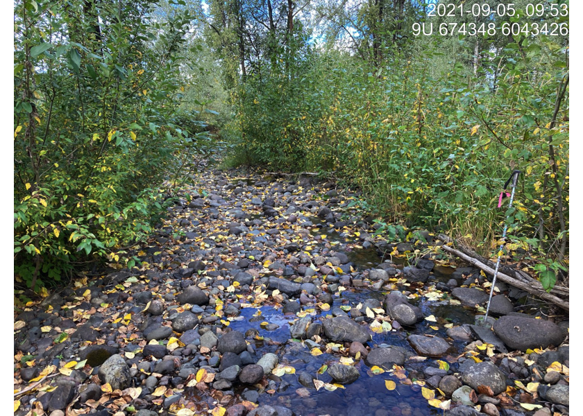
Figure 5.105: Typical habitat downstream of PSCIS crossing 198048.
my_photo2 = fpr::fpr_photo_pull_by_str(str_to_pull = '_d2_')

my_caption2 = paste0('Typical habitat downstream of PSCIS crossing ', my_site, '.')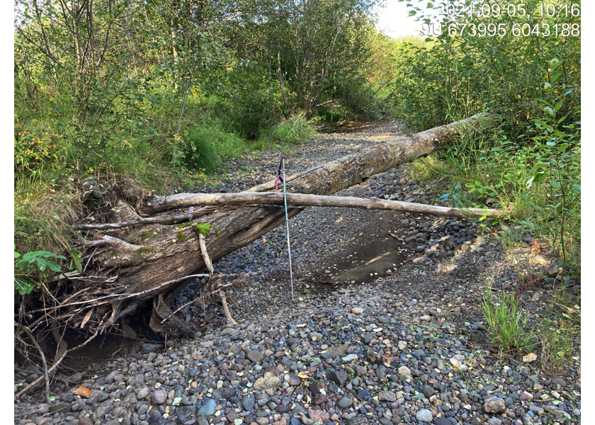
Figure 5.106: Typical habitat downstream of PSCIS crossing 198048.
my_caption <- paste0('Left: ', my_caption1, ' Right: ', my_caption2)

knitr::include_graphics(my_photo1)
knitr::include_graphics("fig/pixel.png")
knitr::include_graphics(my_photo2)
my_photo1 = fpr::fpr_photo_pull_by_str(str_to_pull = '_u1_')
my_caption1 = paste0('Typical habitat upstream of PSCIS crossing ', my_site, '.')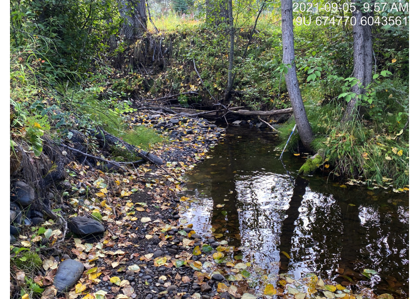
Figure 5.107: Typical habitat upstream of PSCIS crossing 198048.
my_photo2 = fpr::fpr_photo_pull_by_str(str_to_pull = '_u2_')

my_caption2 = paste0('Typical habitat upstream of PSCIS crossing ', my_site, '.')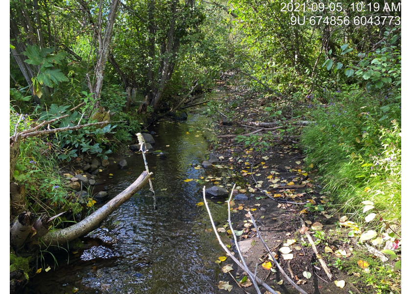
Figure 5.108: Typical habitat upstream of PSCIS crossing 198048.
my_caption <- paste0('Left: ', my_caption1, ' Right: ', my_caption2)

knitr::include_graphics(my_photo1)
knitr::include_graphics("fig/pixel.png")
knitr::include_graphics(my_photo2)
my_photo1 = fpr::fpr_photo_pull_by_str(site = my_site2, str_to_pull = '_u1_')
my_caption1 = paste0('Habitat upstream of PSCIS crossing ', my_site2, '.')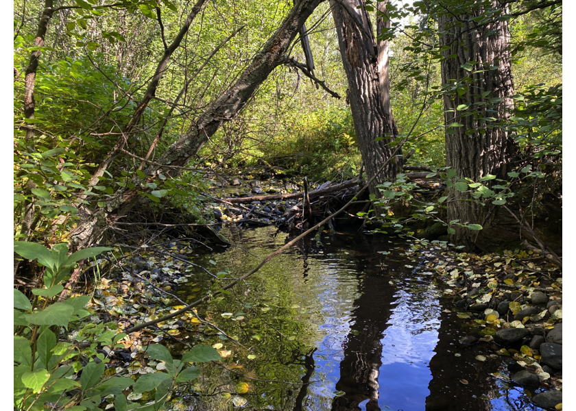
Figure 5.109: Habitat upstream of PSCIS crossing 198049.
my_photo2 = fpr::fpr_photo_pull_by_str(site = my_site2, str_to_pull = '_u2_')

my_caption2 = paste0('Habitat upstream of PSCIS crossing ', my_site2, '.')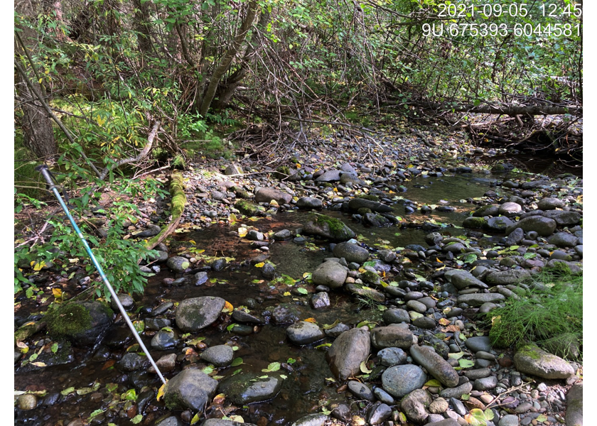
Figure 5.110: Habitat upstream of PSCIS crossing 198049.
my_caption <- paste0('Left: ', my_caption1, ' Right: ', my_caption2)

knitr::include_graphics(my_photo1)
knitr::include_graphics("fig/pixel.png")
knitr::include_graphics(my_photo2)