John Brown Creek - 123770 - Appendix
Site Location
PSCIS crossing 123770 is located on John Brown Creek approximately 650m south of the Moricetown canyon at Moricetown, BC. PSCIS crossing 123770 is located on Highway 16. Crossing 123770 was located 0.3km upstream from the confluence with the Bulkley River and is the responsibility of the Ministry of Transportation and Infrastructure.
Background
At crossing 123770, John Brown Creek is a fifth order stream with a watershed area upstream of the crossing of approximately 80.6km2. The elevation of the watershed ranges from a maximum of 2050m to 375m near the crossing (Table 5.11). Upstream of crossing 123770, coho salmon, cutthroat trout, rainbow trout, chinook salmon, bull trout, and dolly varden have previously been recorded (MoE 2020b; Norris 2020). A. Gottesfeld and Rabnett (2007) reported that although spawner abundance and location are unknown, chinook have been observed in John Brown Creek at 0.4km.
fpr::fpr_table_wshd_sum(site_id = my_site) %>%
  fpr::fpr_kable(caption_text = paste0('Summary of derived upstream watershed statistics for PSCIS crossing ', my_site, '.'),
           footnote_text = 'Elev P60 = Elevation at which 60% of the watershed area is above',
scroll = F)| Site | Area Km | Elev Site | Elev Min | Elev Max | Elev Median | Elev P60 | Aspect |
|---|---|---|---|---|---|---|---|
| 123770 | 80.6 | 385 | 375 | 2050 | 1201 | 1087 | SE |
| * Elev P60 = Elevation at which 60% of the watershed area is above |
Wilson and Rabnett (2007) and McCarthy and Fernando (2015) report that the culvert on John Brown Creek at Highway 16 has received efforts to facilitate backwatering including rock lines to establish backwater pools downstream of the culvert. In 1997, the Ministry of Transportation (MoT) worked in partnership with Fisheries and Oceans Canada, the Ministry of Environment, Lands and Parks, Habitat Conservation Trust Fund, and non-governmental organizations (Gitanyow Fisheries Authorities and the Steelhead Society of BC) to identify and resolve fish passage issues at John Brown Creek. A site assessment indicated that the one meter outlet drop and high culvert velocity was blocking the upstream migration of fish. In 2000, MoT designed and implemented baffles to slow velocity and facilitate fish passage through the culvert. In addition, backwatering was done by constructing a tailwater pool and riffle sequence at the outlet. To reduce the height of the culvert from the stream, riprap was placed downstream of the culvert outlet. Post-remediation monitoring was carried out in 2001 during the spring freshet. Competition between the resident bulltrout and Dolly Varden fish species was observed upstream of the culvert (Sweeting n.d.).
PSCIS stream crossing 123770 was ranked as a high priority for follow up by Irvine (2018), Irvine (2021) and Mazany-Wright et al. (2021) because of significant amounts of habitat modelled as upstream of the crossing. A summary of habitat modelling outputs is presented in Table 5.12. A map of the watershed is provided in map attachment 093M.102.
| Habitat | Potential | Remediation Gain | Remediation Gain (%) |
|---|---|---|---|
| ST Network (km) | 39.6 | 39.3 | 99 |
| ST Lake Reservoir (ha) | 0.0 | 0.0 | – |
| ST Wetland (ha) | 11.4 | 11.4 | 100 |
| ST Slopeclass03 Waterbodies (km) | 0.7 | 0.0 | 0 |
| ST Slopeclass03 (km) | 5.0 | 5.0 | 100 |
| ST Slopeclass05 (km) | 8.1 | 8.0 | 99 |
| ST Slopeclass08 (km) | 8.2 | 7.9 | 96 |
| ST Spawning (km) | 10.3 | 10.3 | 100 |
| ST Rearing (km) | 15.9 | 15.9 | 100 |
| CH Spawning (km) | 10.3 | 10.3 | 100 |
| CH Rearing (km) | 11.2 | 11.2 | 100 |
| CO Spawning (km) | 11.7 | 11.7 | 100 |
| CO Rearing (km) | 11.7 | 11.7 | 100 |
| CO Rearing (ha) | 0.0 | 0.0 | – |
| SK Spawning (km) | 0.0 | 0.0 | – |
| SK Rearing (km) | 0.0 | 0.0 | – |
| SK Rearing (ha) | – | 0.0 | – |
| All Spawning (km) | 11.7 | 11.7 | 100 |
| All Rearing (km) | 15.9 | 15.9 | 100 |
| All Spawning Rearing (km) | 15.9 | 15.9 | 100 |
| * Model data is preliminary and subject to adjustments. |
Stream Characteristics at Crossing
At the time of the survey, PSCIS crossing 123770 was non-backwatered and ranked as a barrier to upstream fish passage according to the provincial protocol (MoE 2011b) (Table 5.13). The crossing consisted on two pipes with baffles installed within the lower elevation pipe. There was a significant outlet drop and the baffled pipe was not embedded for its entire length. Water temperature was 10\(^\circ\)C, pH was 7.2 and conductivity was 94uS/cm. The stream was also assessed at the location of a modelled crossing 1418m upstream from the confluence with the Bulkley River (PSCIS 198043) where a ford was located.
| Location and Stream Data |
|
Crossing Characteristics | – |
|---|---|---|---|
| Date | 2021-09-07 | Crossing Sub Type | Round Culvert |
| PSCIS ID | 123770 | Diameter (m) | 4 |
| External ID | – | Length (m) | 36 |
| Crew | KP AN | Embedded | No |
| UTM Zone | 9 | Depth Embedded (m) | – |
| Easting | 606626.5 | Resemble Channel | No |
| Northing | 6097185 | Backwatered | No |
| Stream | John Brown Creek | Percent Backwatered | – |
| Road | Highway 16 | Fill Depth (m) | 3.5 |
| Road Tenure | MoTi Arterial | Outlet Drop (m) | 0.64 |
| Channel Width (m) | 12.3 | Outlet Pool Depth (m) | 1.5 |
| Stream Slope (%) | 2.9 | Inlet Drop | Yes |
| Beaver Activity | No | Slope (%) | 2 |
| Habitat Value | Medium | Valley Fill | Deep Fill |
| Final score | 37 | Barrier Result | Barrier |
| Fix type | Replace with New Open Bottom Structure | Fix Span / Diameter | 19 |
Photos: From top left clockwise: Road/Site Card, Barrel, Outlet, Downstream, Upstream, Inlet.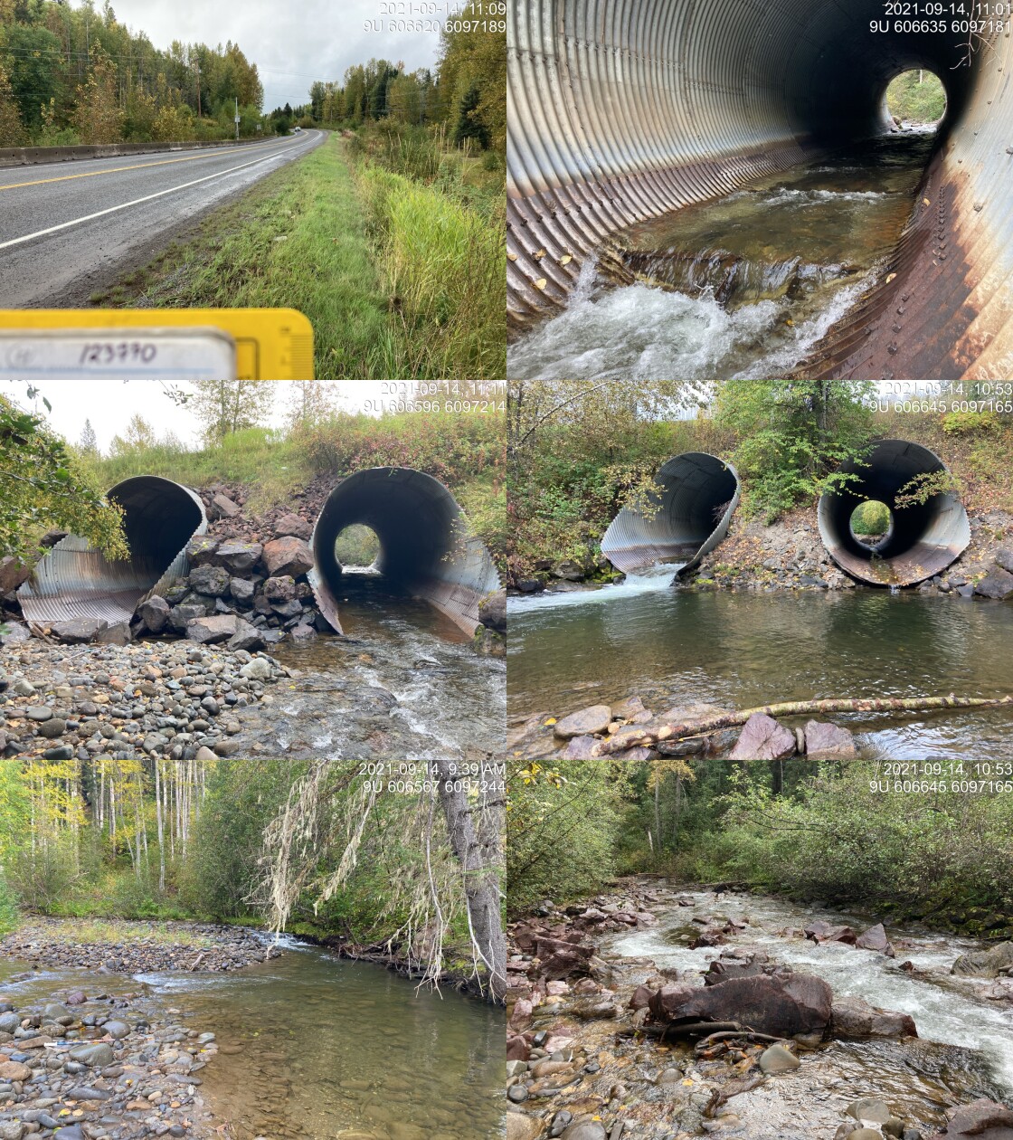
|
|||
| Comments: Both pipes have outlet drop and water flowing through. Water depth in left pipe is 0.01m, left pipe no embeddment. Inlet drop only on right one. Also has baffling with substrate but baffling not in place for downstream ~3m, so not continuous. Estimated pool depth. 10:52 |
Stream Characteristics Downstream
The stream was surveyed downstream from crossing 123770 for 230m to the conflence with the Bulkley River (Figures 5.16 - 5.17). Total cover amount was rated as moderate with boulders dominant. Cover was also present as deep pools and overhanging vegetation. The average channel width was 13.6m, the average wetted width was 8.3m and the average gradient was 4.1%. The dominant substrate was large rock/bedrock with cobbles subdominant. Although rated as an important migration corridor, the habitat was rated as medium value for salmonid rearing and spawning with high flows and limited complexity. Several dead pink salmon were noted on the fan at the confluence with the Bulkley River.
Stream Characteristics Upstream
The stream was surveyed upstream from crossing 123770 for 1000m (Figures 5.18 - 5.19). Total cover amount was rated as moderate with undercut banks dominant. Cover was also present as small woody debris, large woody debris, boulders, deep pools, and overhanging vegetation. The average channel width was 12.2m, the average wetted width was 8.3m and the average gradient was 2.9%. The dominant substrate was cobbles with gravels subdominant. The first 50 - 100m upstream of crossing channel and banks were noted as armoured with riprap. Abundant gravels suitable for resident and anadromous salmonids were noted throughout. The habitat was rated as high value as an important migration corridor containing suitable spawning habitat and having moderate rearing potential.
The stream was also surveyed immediately upstream of PSCIS ford 198043 for 350m (Figures 5.20 - 5.21). Total cover amount was rated as moderate with boulders dominant. Cover was also present as small woody debris and overhanging vegetation.. The average channel width was 11.2m, the average wetted width was 9.1m and the average gradient was 3%. The dominant substrate was cobbles with boulders subdominant. The habitat was rated as high value for salmon rearing and spawning.
Fish Sampling
Electrofishing was conducted with results summarised in Tables 5.15 - 5.16 and Figure 5.15.
Structure Remediation and Cost Estimate
Should restoration/maintenance activities proceed, replacement of PSCIS crossing 123770 with a bridge (19m span) is recommended. The cost of the work is estimated at $11,400,000 for a cost benefit of 1 linear m/$1000 and 12.5 m2/$1000.
Conclusion
There was 11.7km of habitat modelled upstream of crossing 123770 with areas surveyed rated as high value for salmonid rearing and spawning. Crossing 123770 was ranked as a high priority for proceeding to design for replacement. John Brown Creek is a large system with habitat suitable for numerous species includeing coho, steelhead and chinook salmon. Development of a plan to replace the crossing with a bridge may be considered as a prudent step to eliminating an outlet drop, reducing flow velocities at the highway crossing and mitigating risks of a blow out to the baffle induced partial embedding currently in place in the south pipe of the crossing.
tab_hab_summary %>%
  filter(Site  == my_site) %>%
  # select(-Site) %>%
  fpr::fpr_kable(caption_text = paste0('Summary of habitat details for PSCIS crossing ', my_site, '.'),
scroll = F) | Site | Location | Length Surveyed (m) | Channel Width (m) | Wetted Width (m) | Pool Depth (m) | Gradient (%) | Total Cover | Habitat Value |
|---|---|---|---|---|---|---|---|---|
| 123770 | Downstream | 230 | 13.6 | 7.4 | 1.0 | 4.1 | moderate | medium |
| 123770 | Upstream | 1000 | 12.2 | 8.3 | 0.8 | 2.9 | moderate | high |
| 123770 | Upstream2 | 350 | 11.2 | 9.1 | 0.3 | 3.0 | moderate | high |
| site | passes | ef_length_m | ef_width_m | area_m2 | enclosure |
|---|---|---|---|---|---|
| 123770_us_ef1 | 1 | 15.7 | 1.65 | 25.9 | Open |
| 123770_us_ef2 | 1 | 3.3 | 3.23 | 10.7 | Open |
| 123770_us_ef3 | 1 | 1.8 | 2.83 | 5.1 | Open |
| 123770_us_ef4 | 1 | 6.4 | 3.57 | 22.8 | Open |
| 123770_us_ef5 | 1 | 4.8 | 3.03 | 14.5 | Open |
| 123770_us_ef6 | 1 | 2.9 | 2.00 | 5.8 | Open |
| local_name | species_code | life_stage | catch | density_100m2 | nfc_pass |
|---|---|---|---|---|---|
| 123770_us_ef1 | RB | fry | 2 | 7.7 | FALSE |
| 123770_us_ef1 | RB | parr | 4 | 15.4 | FALSE |
| 123770_us_ef2 | CO | fry | 2 | 18.7 | FALSE |
| 123770_us_ef2 | RB | fry | 10 | 93.5 | FALSE |
| 123770_us_ef2 | RB | parr | 4 | 37.4 | FALSE |
| 123770_us_ef3 | RB | fry | 6 | 117.6 | FALSE |
| 123770_us_ef3 | RB | parr | 2 | 39.2 | FALSE |
| 123770_us_ef3 | RB | juvenile | 2 | 39.2 | FALSE |
| 123770_us_ef4 | RB | fry | 1 | 4.4 | FALSE |
| 123770_us_ef4 | RB | parr | 8 | 35.1 | FALSE |
| 123770_us_ef4 | RB | juvenile | 2 | 8.8 | FALSE |
| 123770_us_ef4 | RB | adult | 1 | 4.4 | FALSE |
| 123770_us_ef5 | RB | fry | 1 | 6.9 | FALSE |
| 123770_us_ef5 | RB | parr | 1 | 6.9 | FALSE |
| 123770_us_ef6 | NFC | – | 0 | 0.0 | TRUE |
|
* nfc_pass FALSE means fish were captured in final pass indicating more fish of this species/lifestage may have remained in site. Mark-recaptured required to reduce uncertainties. |
my_caption <- paste0('Densites of fish (fish/100m2) captured upstream of PSCIS crossing ', my_site, '.')

fpr_plot_fish_box() 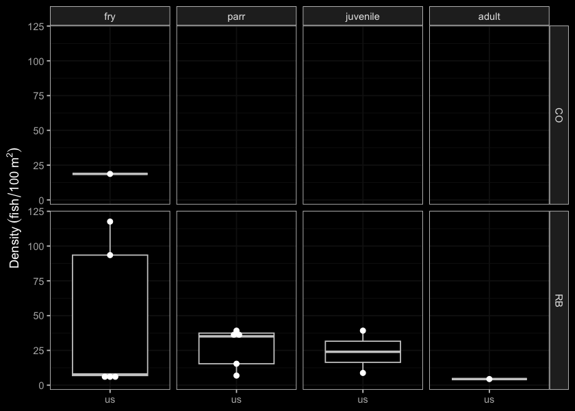
Figure 5.15: Densites of fish (fish/100m2) captured upstream of PSCIS crossing 123770.
my_photo1 = fpr::fpr_photo_pull_by_str(str_to_pull = '_d1_')

my_caption1 = paste0('Typical habitat downstream of PSCIS crossing ', my_site, '.')


# fpr::fpr_photo_flip(site_id = 1802488, str_to_pull = '6257')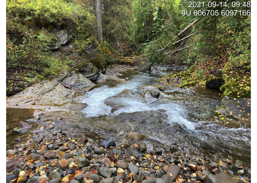
Figure 5.16: Typical habitat downstream of PSCIS crossing 123770.
my_photo2 = fpr::fpr_photo_pull_by_str(str_to_pull = '_d2_')

my_caption2 = paste0('Typical habitat downstream of PSCIS crossing ', my_site, '.')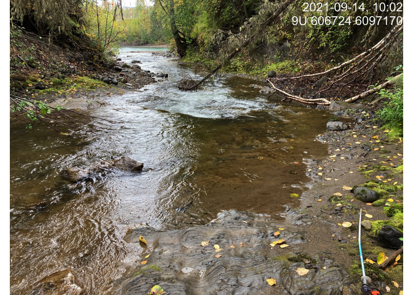
Figure 5.17: Typical habitat downstream of PSCIS crossing 123770.
my_caption <- paste0('Left: ', my_caption1, ' Right: ', my_caption2)

knitr::include_graphics(my_photo1)
knitr::include_graphics("fig/pixel.png")
knitr::include_graphics(my_photo2)
my_photo1 = fpr::fpr_photo_pull_by_str(str_to_pull = '_u1_')
my_caption1 = paste0('Typical habitat upstream of PSCIS crossing ', my_site, '.')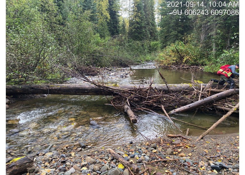
Figure 5.18: Typical habitat upstream of PSCIS crossing 123770.
my_photo2 = fpr::fpr_photo_pull_by_str(str_to_pull = '_u2_')

my_caption2 = paste0('Typical habitat upstream of PSCIS crossing ', my_site, '.')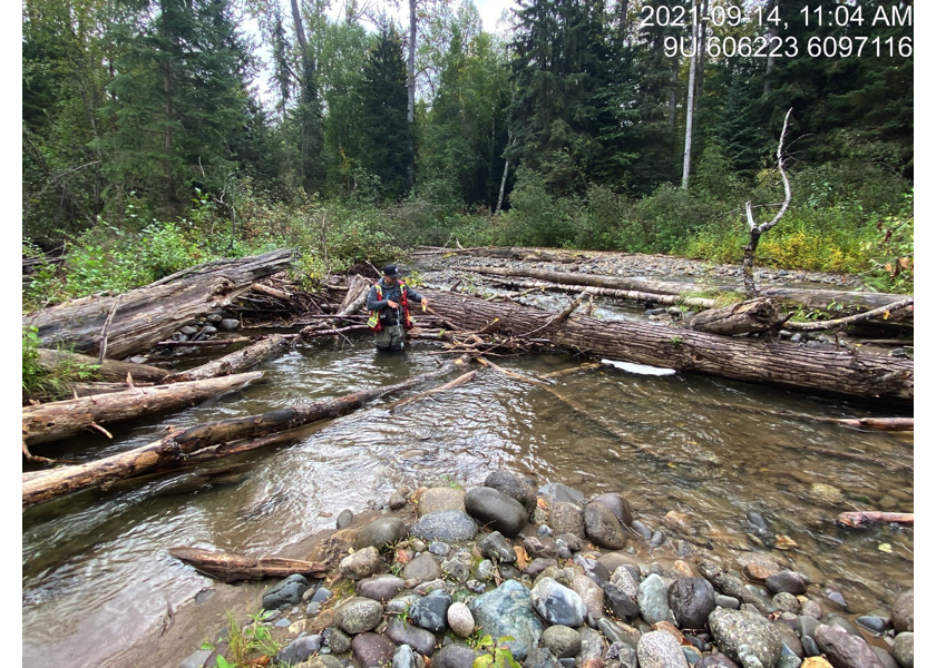
Figure 5.19: Typical habitat upstream of PSCIS crossing 123770.
my_caption <- paste0('Left: ', my_caption1, ' Right: ', my_caption2)

knitr::include_graphics(my_photo1)
knitr::include_graphics("fig/pixel.png")
knitr::include_graphics(my_photo2)
my_photo1 = fpr::fpr_photo_pull_by_str(str_to_pull = '_u3_')
my_caption1 = paste0('Typical habitat upstream of PSCIS crossing ', my_site, '.')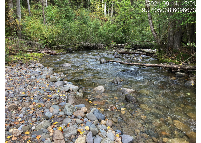
Figure 5.20: Typical habitat upstream of PSCIS crossing 123770.
my_photo2 = fpr::fpr_photo_pull_by_str(str_to_pull = '_u4_')

my_caption2 = paste0('Typical habitat upstream of PSCIS crossing ', my_site, '.')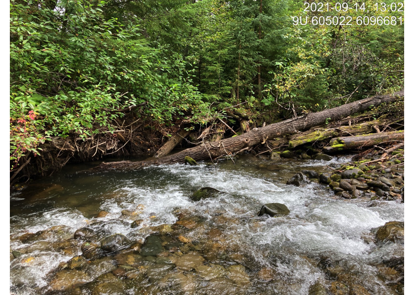
Figure 5.21: Typical habitat upstream of PSCIS crossing 123770.
my_caption <- paste0('Left: ', my_caption1, ' Right: ', my_caption2)

knitr::include_graphics(my_photo1)
knitr::include_graphics("fig/pixel.png")
knitr::include_graphics(my_photo2)