Ailport Creek - 197976 & 197975 - Appendix
Site Location
PSCIS crossing 197976 and 197975 are located on Ailport Creek approximately 7km south-west of Topley, BC. PSCIS crossing 197976 is located on Highway 16 and 197975 is located on a private driveway. Crossing 197976 was located 4.2km upstream from the confluence with the Bulkley River and crossing 197975 was located 393m upstream fo Highway 16. Crossing 197976 is the responsibility of the Ministry of Transportation and Infrastructure and crossing 197976 is the responsibility of the private land owner.
Background
At crossing 197976, Ailport Creek is a fifth order stream with a watershed area upstream of the crossing of approximately 66.9km2. The elevation of the watershed ranges from a maximum of 1445m to 375m near the crossing (Table 5.60).
Upstream of crossing 197976, cutthroat trout, coho salmon, and rainbow trout have previously been recorded (MoE 2020b; Norris 2020). A. Gottesfeld and Rabnett (2007) report that upper Bulkley coho and steelhead spawn and rear in Ailport Creek. An adjacent landowner noted that in the past, during a high flow event, an adult steelhead was stranded in a pond at the side of the field adjacent to the stream upstream of crossing 197975. Another adjacent landowner reports that historic high flow events in the watershed were likely related to beaver dam failures in the upper reaches of the stream network.
DFO (1998), (as cited in McCarthy and Fernando (2015)) reported that crossing 197976 was a barrier at low flows. Following site visits in 2007 and 2017, Wilson and Rabnett (2007) and Smith (2018) reported that the culvert was not an issue for passage. There were no records found of crossing 197975 being assessed for fish passage in the past.
Government of British Columbia (2022) records indicate that downstream of 197976 a range tenure is held by 102039220 Saskatchewan Ltd. and that tenure for the first 210m of stream immediately upstream of the highway is registered to Danny Staudt. Additionally, there are multiple other range tenures overlapping Ailport Creek and tributaries further up in the watershed.
There are numerous modelled stream crossing locations upstream of 197975 however all crossings on the mainstem appear to be bridges in aerial imagery.
PSCIS stream crossings on Ailport Creek were ranked as high priorities for follow up by Irvine (2021) and Mazany-Wright et al. (2021) because of significant amounts of habitat modelled as upstream of the crossing. A total of 42ha of lake and 374ha of wetland is modelled upstream with a summary of additional habitat modelling outputs presented in Tables 5.61 - 5.62. A map of the watershed is provided in map attachment 093L.115.
fpr::fpr_table_wshd_sum(site_id = my_site) %>%
  fpr::fpr_kable(caption_text = paste0('Summary of derived upstream watershed statistics for PSCIS crossing ', my_site, '.'),
           footnote_text = 'Elev P60 = Elevation at which 60% of the watershed area is above',
scroll = F)| Site | Area Km | Elev Site | Elev Min | Elev Max | Elev Median | Elev P60 | Aspect |
|---|---|---|---|---|---|---|---|
| 197976 | 66.9 | 729 | 736 | 1445 | 1186 | 1093 | SSW |
| * Elev P60 = Elevation at which 60% of the watershed area is above |
| Habitat | Potential | Remediation Gain | Remediation Gain (%) |
|---|---|---|---|
| ST Network (km) | 53.1 | 0.4 | 1 |
| ST Lake Reservoir (ha) | 29.8 | 0.0 | 0 |
| ST Wetland (ha) | 211.0 | 0.0 | 0 |
| ST Slopeclass03 Waterbodies (km) | 10.7 | 0.0 | 0 |
| ST Slopeclass03 (km) | 17.6 | 0.4 | 2 |
| ST Slopeclass05 (km) | 9.8 | 0.0 | 0 |
| ST Slopeclass08 (km) | 7.6 | 0.0 | 0 |
| ST Spawning (km) | 9.9 | 0.4 | 4 |
| ST Rearing (km) | 19.8 | 0.4 | 2 |
| CH Spawning (km) | 9.9 | 0.4 | 4 |
| CH Rearing (km) | 11.9 | 0.4 | 3 |
| CO Spawning (km) | 13.5 | 0.4 | 3 |
| CO Rearing (km) | 25.1 | 0.4 | 2 |
| CO Rearing (ha) | 96.1 | 0.0 | 0 |
| SK Spawning (km) | 0.0 | 0.0 | – |
| SK Rearing (km) | 0.0 | 0.0 | – |
| SK Rearing (ha) | – | 0.0 | – |
| All Spawning (km) | 13.5 | 0.4 | 3 |
| All Rearing (km) | 28.2 | 0.4 | 1 |
| All Spawning Rearing (km) | 28.2 | 0.4 | 1 |
| * Model data is preliminary and subject to adjustments. |
| Habitat | Potential | Remediation Gain | Remediation Gain (%) |
|---|---|---|---|
| ST Network (km) | 52.8 | 38.4 | 73 |
| ST Lake Reservoir (ha) | 29.8 | 28.9 | 97 |
| ST Wetland (ha) | 211.0 | 149.7 | 71 |
| ST Slopeclass03 Waterbodies (km) | 10.7 | 0.0 | 0 |
| ST Slopeclass03 (km) | 17.2 | 14.5 | 84 |
| ST Slopeclass05 (km) | 9.8 | 5.6 | 57 |
| ST Slopeclass08 (km) | 7.6 | 6.6 | 87 |
| ST Spawning (km) | 9.6 | 9.3 | 97 |
| ST Rearing (km) | 19.4 | 16.7 | 86 |
| CH Spawning (km) | 9.6 | 9.3 | 97 |
| CH Rearing (km) | 11.5 | 10.8 | 94 |
| CO Spawning (km) | 13.1 | 11.4 | 87 |
| CO Rearing (km) | 24.7 | 21.8 | 88 |
| CO Rearing (ha) | 96.1 | 0.0 | 0 |
| SK Spawning (km) | 0.0 | 0.0 | – |
| SK Rearing (km) | 0.0 | 0.0 | – |
| SK Rearing (ha) | – | 0.0 | – |
| All Spawning (km) | 13.1 | 11.4 | 87 |
| All Rearing (km) | 27.8 | 24.5 | 88 |
| All Spawning Rearing (km) | 27.8 | 24.5 | 88 |
| * Model data is preliminary and subject to adjustments. |
Stream Characteristics at Crossing
At the time of the survey, PSCIS crossing 197976 was 50% backwatered, un-embedded and ranked as a barrier to upstream fish passage according to the provincial protocol (MoE 2011b) (Table 5.63). A juvenile fish (~140 cm) was noted as easily swimming upstream through the culvert during the survey. PSCIS crossing 197976 was not backwatered, not embedded and ranked as a barrier to upstream fish passage according to the provincial protocol (Table 5.64). Water temperature was 11\(^\circ\)C, pH was 7 and conductivity was 248uS/cm.
| Location and Stream Data |
|
Crossing Characteristics | – |
|---|---|---|---|
| Date | 2021-08-31 | Crossing Sub Type | Oval Culvert |
| PSCIS ID | 197976 | Diameter (m) | 3.5 |
| External ID | – | Length (m) | 23 |
| Crew | KP | Embedded | No |
| UTM Zone | 9 | Depth Embedded (m) | – |
| Easting | 680644.8 | Resemble Channel | No |
| Northing | 6039756 | Backwatered | Yes |
| Stream | Ailport Creek | Percent Backwatered | 50 |
| Road | Highway 16 | Fill Depth (m) | 3 |
| Road Tenure | Highway | Outlet Drop (m) | – |
| Channel Width (m) | 7.5 | Outlet Pool Depth (m) | 0.55 |
| Stream Slope (%) | 4 | Inlet Drop | No |
| Beaver Activity | No | Slope (%) | 2 |
| Habitat Value | High | Valley Fill | Deep Fill |
| Final score | 24 | Barrier Result | Barrier |
| Fix type | Replace with New Open Bottom Structure | Fix Span / Diameter | 12.5 |
Photos: From top left clockwise: Road/Site Card, Barrel, Outlet, Downstream, Upstream, Inlet.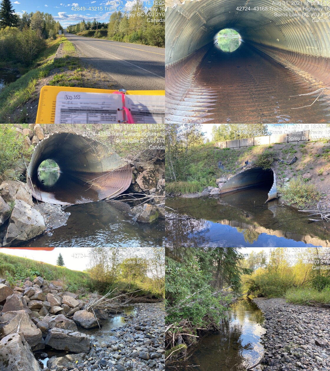
|
|||
| Comments: Fish sighted upstream, not aligned with stream, channel runs into rip rap berm of highway then over to closed bottom structure. Pool (40cn) on upstream inlet. Fish sighted in downstream pool. 18:16 |
| Location and Stream Data |
|
Crossing Characteristics | – |
|---|---|---|---|
| Date | 2021-08-31 | Crossing Sub Type | Round Culvert |
| PSCIS ID | 197975 | Diameter (m) | 3 |
| External ID | – | Length (m) | 10 |
| Crew | KP | Embedded | No |
| UTM Zone | 9 | Depth Embedded (m) | – |
| Easting | 680832 | Resemble Channel | No |
| Northing | 6040045 | Backwatered | No |
| Stream | Ailport Creek | Percent Backwatered | – |
| Road | Private Driveway | Fill Depth (m) | 0.5 |
| Road Tenure | Unclassified | Outlet Drop (m) | 0.3 |
| Channel Width (m) | 6.5 | Outlet Pool Depth (m) | 1.45 |
| Stream Slope (%) | 3 | Inlet Drop | No |
| Beaver Activity | No | Slope (%) | 4 |
| Habitat Value | Medium | Valley Fill | Deep Fill |
| Final score | 36 | Barrier Result | Barrier |
| Fix type | Replace with New Open Bottom Structure | Fix Span / Diameter | 11.5 |
Photos: From top left clockwise: Road/Site Card, Barrel, Outlet, Downstream, Upstream, Inlet.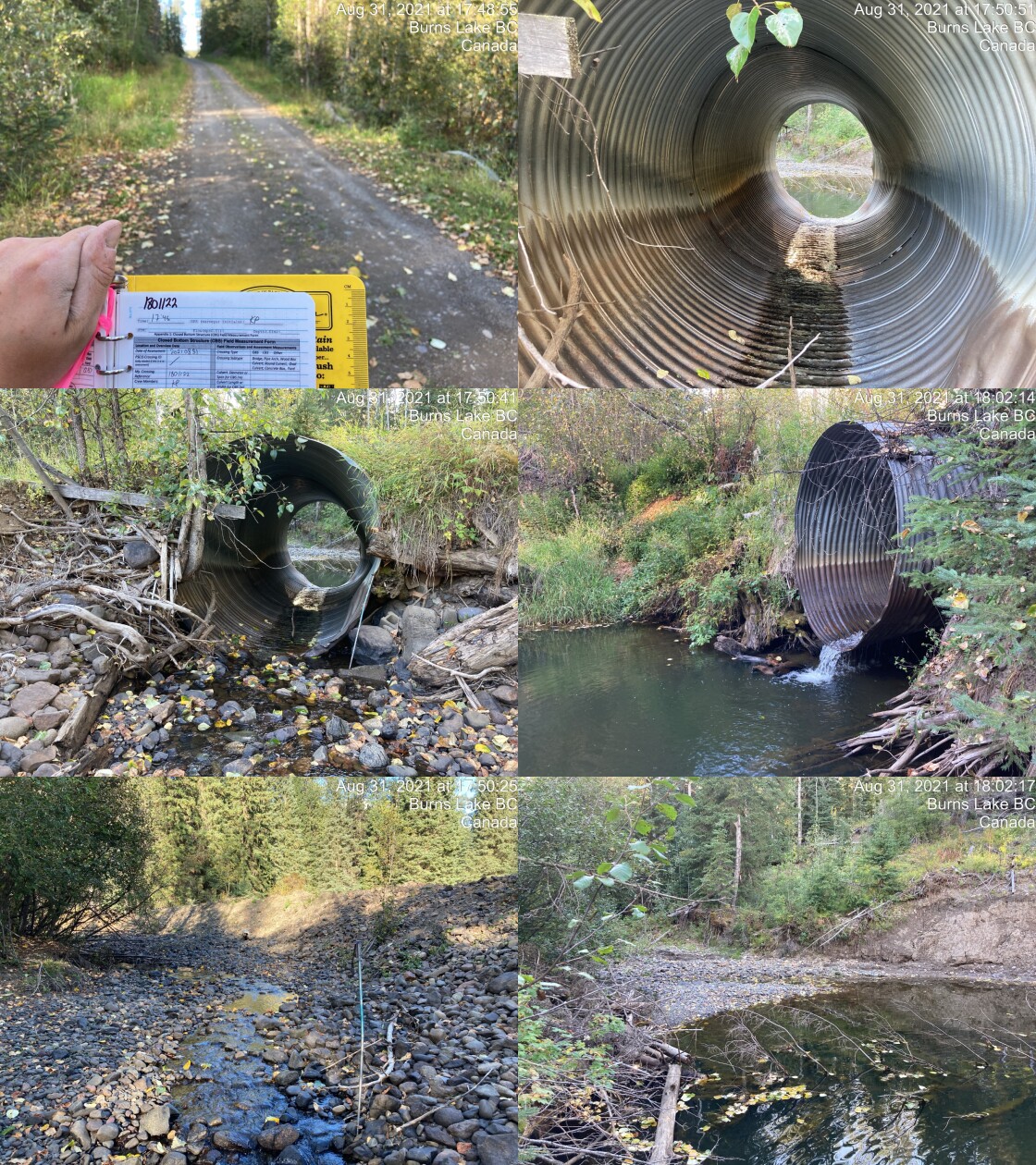
|
|||
| Comments: Dredging upstream, channel width not natural. Signs of major flooding including wear on upstream sides of culvert. No riparian zone on river left upstream. Culvert 4% but has bend at last 2m outlet drop and outlet pool depth are estimates. This stream could use some restoration. 17:46 |
Stream Characteristics Downstream of 197976
The stream was surveyed downstream from crossing 197976 for 575m (Figures 5.80 - 5.81). Total cover amount was rated as moderate with deep pools dominant. Cover was also present as small woody debris, undercut banks, overhanging vegetation, and instream vegetation.The dominant substrate was cobbles with gravels sub-dominant.The average channel width was 7.7m, the average wetted width was 3.5m, and the average gradient was 1%. Although side channels continued to flow throughout the area surveyed, approximately 160m downstream of the crossing the main channel was dewatered below the location of a beaver dam. Areas of riparian and bank degradation from cattle trampling were noted throughout the area surveyed and there was fencing spanning the channel. Large deposits of substrate and clumped large woody debris piles were observed within widened channel areas indicating disturbance and high flow events. There were abundant gravels presetn suitable for spawning resident and anadromous salmonids. Habitat was rated as high value for salmonid rearing and spawning with numerous fish observed and numerous deep pools to 0.95m deep.
Stream Characteristics Upstream of 197976 and downstream of 197975
The stream was surveyed upstream from crossing 197976 for 345m (Figures 5.82 - 5.83). Total cover amount was rated as moderate with deep pools dominant. Cover was also present as small woody debris, undercut banks, and overhanging vegetation.The dominant substrate was cobbles with gravels sub-dominant.The average channel width was 8.1m, the average wetted width was 4.2m, and the average gradient was 2.2%. Fish were observed throughout the area surveyed and extensive algae growth was present on stream substrates. Large woody debris was rare and riparian/bank damage due to livestock was minimal and located at what appeared to be watering sites. Fencing was located across the stream in multiple locations. Patches of gravels suitable for spawning were present. Habitat value was rated as medium as the surveyed area was considered an important migration corridor containing suitable spawning habitat and having moderate rearing potential.
5.4 Stream Characteristics Upstream of 197975
The stream was surveyed upstream from crossing 197975 for 550m (Figures 5.84 - 5.85). The dominant substrate was cobbles with gravels sub-dominant.Total cover amount was rated as moderate with deep pools dominant. Cover was also present as small woody debris, boulders, undercut banks, and overhanging vegetation.The average channel width was 7.7m, the average wetted width was 3.5m, and the average gradient was 3%. Immediately upstream of the crossing for ~80m, extensive anthropogenic damage was noted due to dredging of the channel. Heavy cattle grazing was also observed on the left bank. Juvenile salmonids were observed occasionally throughout the area surveyed. Fencing was located across the stream approximately 250m upstream of the culvert. Patches of gravels suitable for spawning were present. Habitat value was rated as medium as the surveyed area was considered an important migration corridor containing suitable spawning habitat and having moderate rearing potential.
Fish Sampling
Electrofishing was conducted with results summarised in Tables 5.66 - 5.67 and Figure 5.79.
Structure Remediation and Cost Estimate
Should restoration/maintenance activities proceed, replacement of PSCIS crossing 197976 with a bridge (12.5m span) is recommended. The cost of the work is estimated at $7,500,000 for a cost benefit of 3.3 linear m/$1000 and 27.1 m2/$1000. As the crossing partially backwaters naturally, a plan to backwater the crossing could also be of consideration in the short term with a rough cost estimate to complete of $25,000.
Should restoration/maintenance activities proceed, replacement of PSCIS crossing 197975 with a bridge (11.5m span) is recommended. The cost of the work is estimated at $230,000 for a cost benefit of 107.3 linear m/$1000 and 826.6 m2/$1000. Relocation of the driveway accessing the private land from the other side of the stream and removal of the crossing could also be considered.
Conclusion
There was 24.7km of habitat modelled upstream of crossing 197975 rated as medium value for salmonid rearing and spawning. Crossing 197976 was ranked as a moderate priority for proceeding to design for replacement as it appears to pass fish during most flows. Crossing 197975 was ranked as a moderate priority for proceeding to design for replacement as it appears to likely present a more serious impediment to upstream passage and because implementation of the works can be considered cost effective and logistically less complicated than works on a major highway. As Ailport Creek appears to be a high value fish stream with significant impacts due to culvert maintenance (dredging), adjacent land use (cattle trampled banks and grazed/removed riparian vegetation) and high flow events (potentially beaver dam failure related), it is recommended that a plan be developed to work with adjacent landowners and tenure holders to exclude cattle from the riparian area, implement stream restoration actions and explore possibilities related to progressive beaver management in the watershed.
tab_hab_summary %>%
  filter(Site  == my_site |
           Site  == my_site2) %>%
  # select(-Site) %>%
  fpr::fpr_kable(caption_text = paste0('Summary of habitat details for PSCIS crossing ', my_site, '.'),
scroll = F) | Site | Location | Length Surveyed (m) | Channel Width (m) | Wetted Width (m) | Pool Depth (m) | Gradient (%) | Total Cover | Habitat Value |
|---|---|---|---|---|---|---|---|---|
| 197975 | Upstream | 550 | 7.7 | 3.5 | 0.3 | 3.0 | moderate | medium |
| 197976 | Downstream | 575 | 7.7 | 3.5 | 0.5 | 1.0 | moderate | high |
| 197976 | Upstream | 345 | 8.1 | 4.2 | 0.3 | 2.2 | moderate | medium |
| site | passes | ef_length_m | ef_width_m | area_m2 | enclosure |
|---|---|---|---|---|---|
| 197975_ds_ef1 | 1 | 3.8 | 4.27 | 16.2 | Open |
| 197975_ds_ef2 | 1 | 3.9 | 3.60 | 14.0 | Open |
| 197975_us_ef1 | 1 | 6.0 | 3.30 | 19.8 | Open |
| 197975_us_ef2 | 1 | 3.0 | 2.97 | 8.9 | Open |
| local_name | species_code | life_stage | catch | density_100m2 | nfc_pass |
|---|---|---|---|---|---|
| 197975_ds_ef1 | RB | fry | 2 | 12.3 | FALSE |
| 197975_ds_ef1 | RB | parr | 1 | 6.2 | FALSE |
| 197975_ds_ef2 | CO | fry | 1 | 7.1 | FALSE |
| 197975_ds_ef2 | CO | parr | 4 | 28.6 | FALSE |
| 197975_ds_ef2 | RB | fry | 1 | 7.1 | FALSE |
| 197975_ds_ef2 | RB | parr | 10 | 71.4 | FALSE |
| 197975_ds_ef2 | RB | juvenile | 2 | 14.3 | FALSE |
| 197975_ds_ef2 | RB | adult | 1 | 7.1 | FALSE |
| 197975_us_ef1 | CO | parr | 2 | 10.1 | FALSE |
| 197975_us_ef1 | RB | fry | 2 | 10.1 | FALSE |
| 197975_us_ef1 | RB | parr | 14 | 70.7 | FALSE |
| 197975_us_ef1 | RB | juvenile | 5 | 25.3 | FALSE |
| 197975_us_ef1 | RB | adult | 5 | 25.3 | FALSE |
| 197975_us_ef2 | RB | fry | 5 | 56.2 | FALSE |
| 197975_us_ef2 | RB | parr | 7 | 78.7 | FALSE |
| 197975_us_ef2 | RB | adult | 2 | 22.5 | FALSE |
|
* nfc_pass FALSE means fish were captured in final pass indicating more fish of this species/lifestage may have remained in site. Mark-recaptured required to reduce uncertainties. |
my_caption <- paste0('Densites of fish (fish/100m2) capture upstream and downstream of PSCIS crossing ', my_site2, '.')

fpr_plot_fish_box(sit = my_site2) 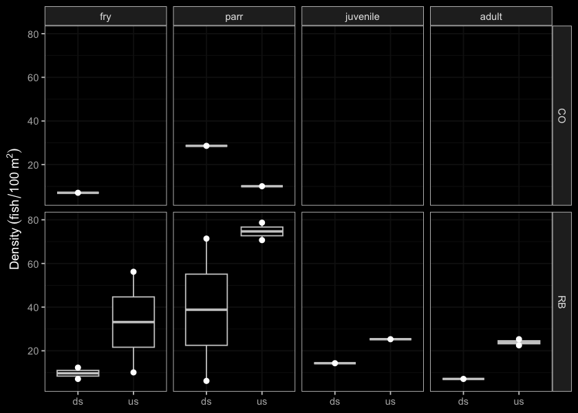
Figure 5.79: Densites of fish (fish/100m2) capture upstream and downstream of PSCIS crossing 197975.
my_photo1 = fpr::fpr_photo_pull_by_str(str_to_pull = '_d1_')

my_caption1 = paste0('Typical habitat downstream of PSCIS crossing ', my_site, '.')


# fpr::fpr_photo_flip(site_id = 1802488, str_to_pull = '6257')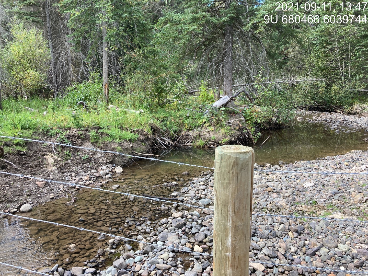
Figure 5.80: Typical habitat downstream of PSCIS crossing 197976.
my_photo2 = fpr::fpr_photo_pull_by_str(str_to_pull = '_d2_')

my_caption2 = paste0('Typical habitat downstream of PSCIS crossing ', my_site, '.')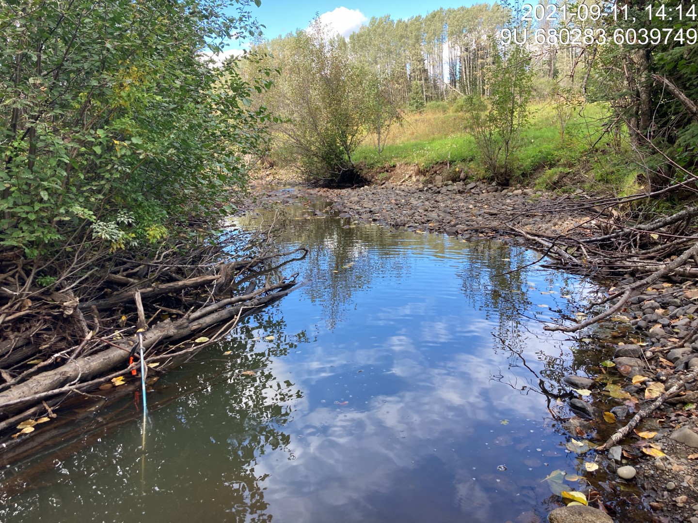
Figure 5.81: Typical habitat downstream of PSCIS crossing 197976.
my_caption <- paste0('Left: ', my_caption1, ' Right: ', my_caption2)

knitr::include_graphics(my_photo1)
knitr::include_graphics("fig/pixel.png")
knitr::include_graphics(my_photo2)
my_photo1 = fpr::fpr_photo_pull_by_str(str_to_pull = '_u1_')
my_caption1 = paste0('Typical habitat upstream of PSCIS crossing ', my_site, '.')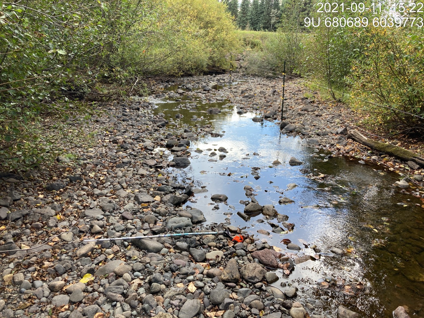
Figure 5.82: Typical habitat upstream of PSCIS crossing 197976.
my_photo2 = fpr::fpr_photo_pull_by_str(str_to_pull = '_u2_')

my_caption2 = paste0('Typical habitat upstream of PSCIS crossing ', my_site, '.')
Figure 5.83: Typical habitat upstream of PSCIS crossing 197976.
my_caption <- paste0('Left: ', my_caption1, ' Right: ', my_caption2)

knitr::include_graphics(my_photo1)
knitr::include_graphics("fig/pixel.png")
knitr::include_graphics(my_photo2)
my_photo1 = fpr::fpr_photo_pull_by_str(site = my_site2, str_to_pull = '_u1_')
my_caption1 = paste0('Typical habitat upstream of PSCIS crossing ', my_site2, '.')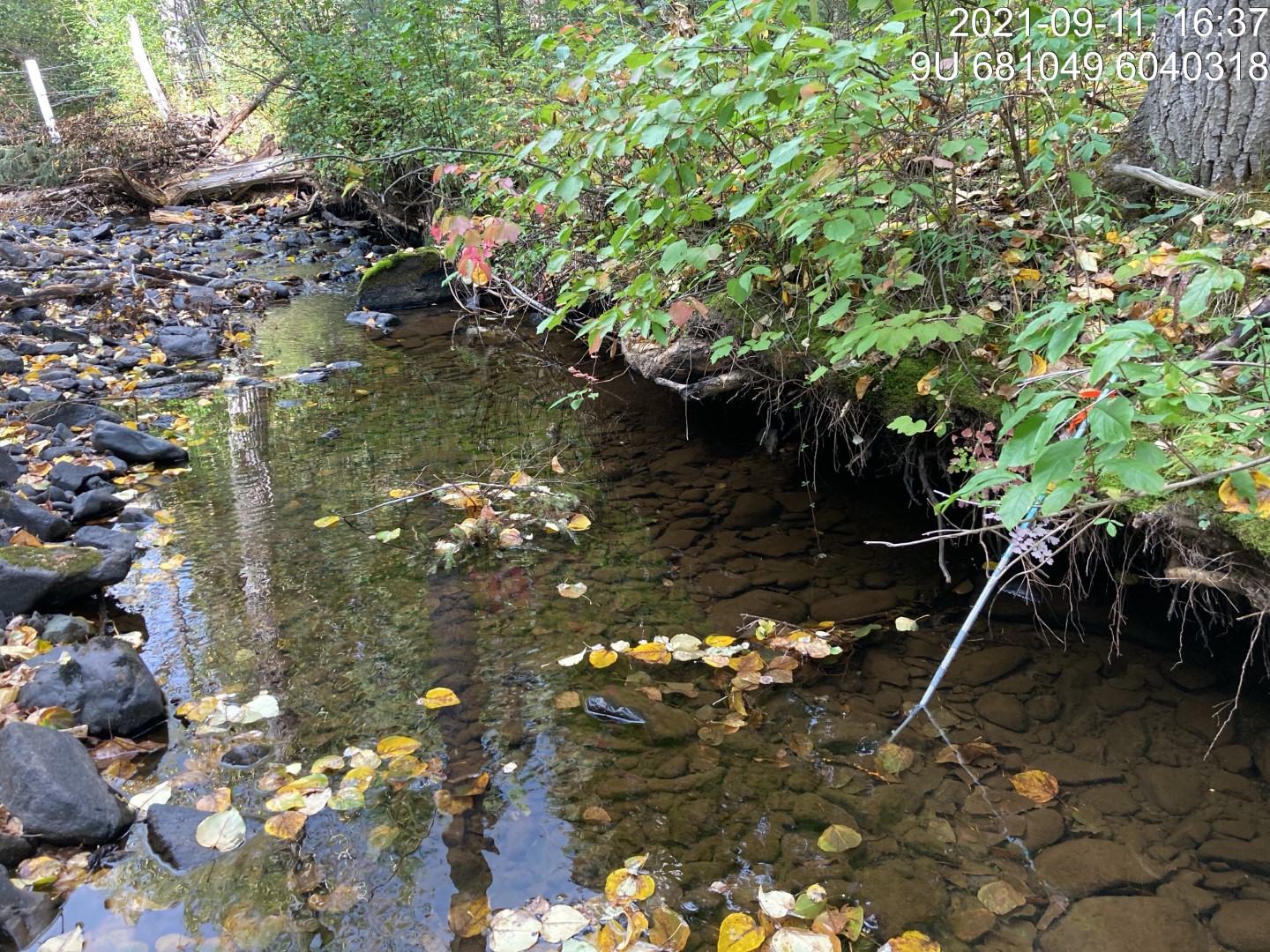
Figure 5.84: Typical habitat upstream of PSCIS crossing 197975.
my_photo2 = fpr::fpr_photo_pull_by_str(site = my_site2, str_to_pull = '_u2_')

my_caption2 = paste0('Typical habitat upstream of PSCIS crossing ', my_site2, '.')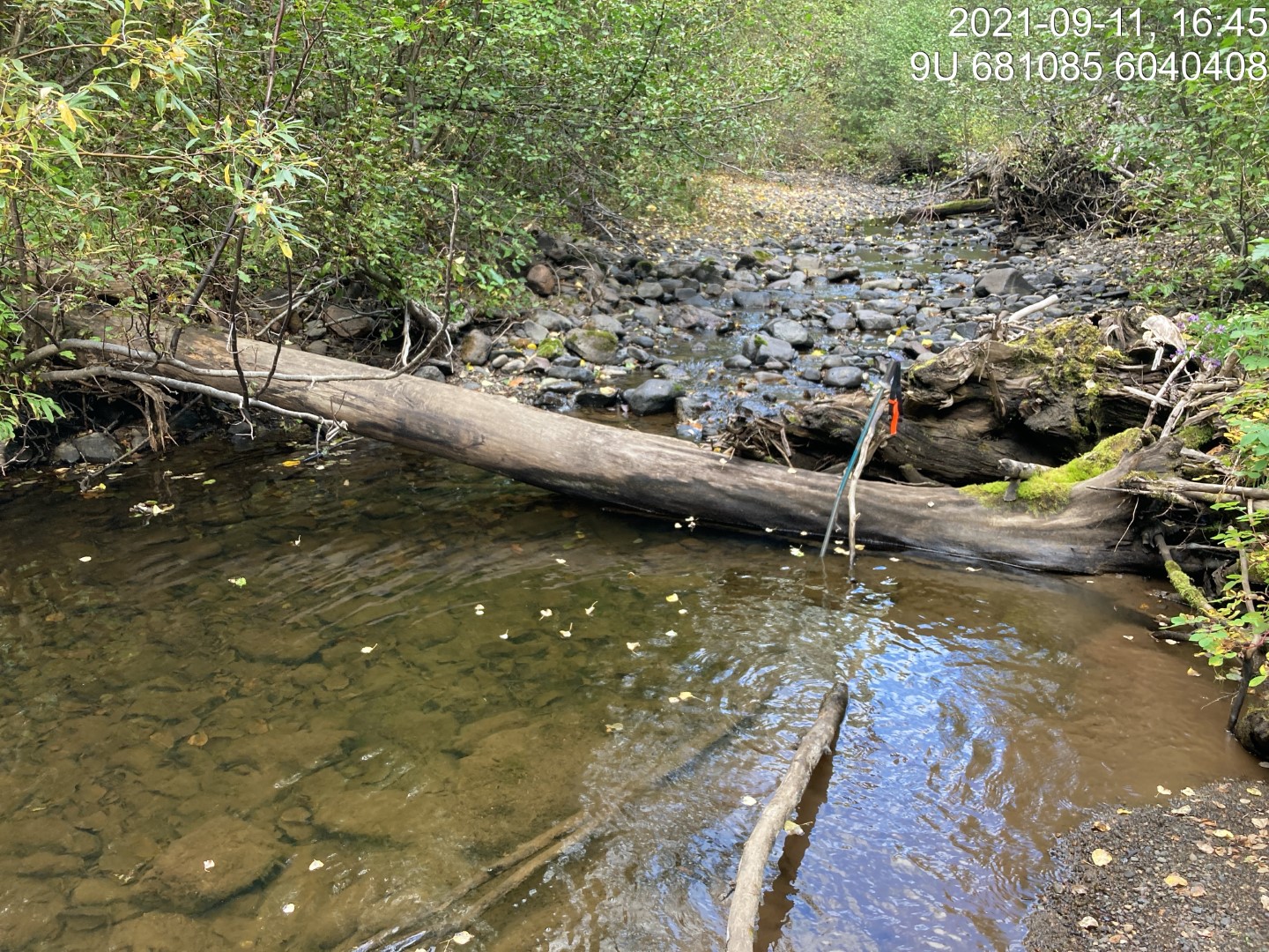
Figure 5.85: Typical habitat upstream of PSCIS crossing 197975.
my_caption <- paste0('Left: ', my_caption1, ' Right: ', my_caption2)

knitr::include_graphics(my_photo1)
knitr::include_graphics("fig/pixel.png")
knitr::include_graphics(my_photo2)