Peacock Creek - 197962 - Appendix
Site Location
PSCIS crossing 197962 was located on Peacock Creek approximately 9km west of Houston, BC. Crossing 197962 was located on Morice FSR approximately 1.2km upstream from the confluence with the Morice River. Crossing 197962 is the responsibility of the Ministry of Forests.
Background
At crossing 197962, Peacock Creek is a fourth order stream with a watershed area upstream of the crossing of approximately 36.3km2. The elevation of the watershed ranges from a maximum of 1822m to 654m near the crossing (Table 5.49).
Upstream of crossing 197962, no fish species have previously been recorded within provincial databases (MoE 2020b; Norris 2020).
McCarthy and Fernando (2015) and Smith (2018) reported that a large concrete weir and spillway that were built in the 1990s were not functioning correctly and that the crossing was a high priority fish barrier. Gaboury and Smith (2016) conducted a site survey in 2015 and produced design options to remediate passage. There were no records of crossing 197962 within PSCIS before the 2021 assessment data was loaded in. The site was prioritized for follow up because of significant amounts of habitat modelled as upstream of the crossing (Table 5.50). A map of the watershed is provided in map attachment 093L.109.
fpr::fpr_table_wshd_sum(site_id = my_site) %>%
  fpr::fpr_kable(caption_text = paste0('Summary of derived upstream watershed statistics for PSCIS crossing ', my_site, '.'),
           footnote_text = 'Elev P60 = Elevation at which 60% of the watershed area is above',
scroll = F)| Site | Area Km | Elev Site | Elev Min | Elev Max | Elev Median | Elev P60 | Aspect |
|---|---|---|---|---|---|---|---|
| 197962 | 36.3 | 631 | 654 | 1822 | 1166 | 1119 | E |
| * Elev P60 = Elevation at which 60% of the watershed area is above |
| Habitat | Potential | Remediation Gain | Remediation Gain (%) |
|---|---|---|---|
| ST Network (km) | 6.1 | 6.1 | 100 |
| ST Lake Reservoir (ha) | – | 0.0 | – |
| ST Wetland (ha) | – | 0.0 | – |
| ST Slopeclass03 Waterbodies (km) | 0.0 | 0.0 | – |
| ST Slopeclass03 (km) | 0.4 | 0.4 | 100 |
| ST Slopeclass05 (km) | 4.5 | 4.5 | 100 |
| ST Slopeclass08 (km) | 0.1 | 0.1 | 100 |
| ST Spawning (km) | 3.0 | 3.0 | 100 |
| ST Rearing (km) | 4.9 | 4.9 | 100 |
| CH Spawning (km) | 3.0 | 3.0 | 100 |
| CH Rearing (km) | 4.8 | 4.8 | 100 |
| CO Spawning (km) | 4.8 | 4.8 | 100 |
| CO Rearing (km) | 4.8 | 4.8 | 100 |
| CO Rearing (ha) | – | 0.0 | – |
| SK Spawning (km) | 0.0 | 0.0 | – |
| SK Rearing (km) | 0.0 | 0.0 | – |
| SK Rearing (ha) | – | 0.0 | – |
| All Spawning (km) | 4.8 | 4.8 | 100 |
| All Rearing (km) | 4.9 | 4.9 | 100 |
| All Spawning Rearing (km) | 4.9 | 4.9 | 100 |
| * Model data is preliminary and subject to adjustments. |
Stream Characteristics at Crossing
At the time of the survey, PSCIS crossing 197962 was un-backwatered, un-embedded and ranked as a barrier to upstream fish passage according to the provincial protocol (MoE 2011b) (Table 5.51). Water temperature was 8\(^\circ\)C, pH was 8.2 and conductivity was 222uS/cm.
| Location and Stream Data |
|
Crossing Characteristics | – |
|---|---|---|---|
| Date | 2021-09-07 | Crossing Sub Type | Oval Culvert |
| PSCIS ID | 197962 | Diameter (m) | 3.6 |
| External ID | – | Length (m) | 15 |
| Crew | KP | Embedded | No |
| UTM Zone | 9 | Depth Embedded (m) | – |
| Easting | 643460.3 | Resemble Channel | No |
| Northing | 6025890 | Backwatered | No |
| Stream | Peacock Creek | Percent Backwatered | – |
| Road | Morice FSR | Fill Depth (m) | 3.5 |
| Road Tenure | FLNR DND 4656 | Outlet Drop (m) | 0.5 |
| Channel Width (m) | 9.3 | Outlet Pool Depth (m) | 1.05 |
| Stream Slope (%) | 4 | Inlet Drop | Yes |
| Beaver Activity | No | Slope (%) | 3.5 |
| Habitat Value | Medium | Valley Fill | Deep Fill |
| Final score | 39 | Barrier Result | Barrier |
| Fix type | Replace with New Open Bottom Structure | Fix Span / Diameter | 16 |
Photos: From top left clockwise: Road/Site Card, Barrel, Outlet, Downstream, Upstream, Inlet.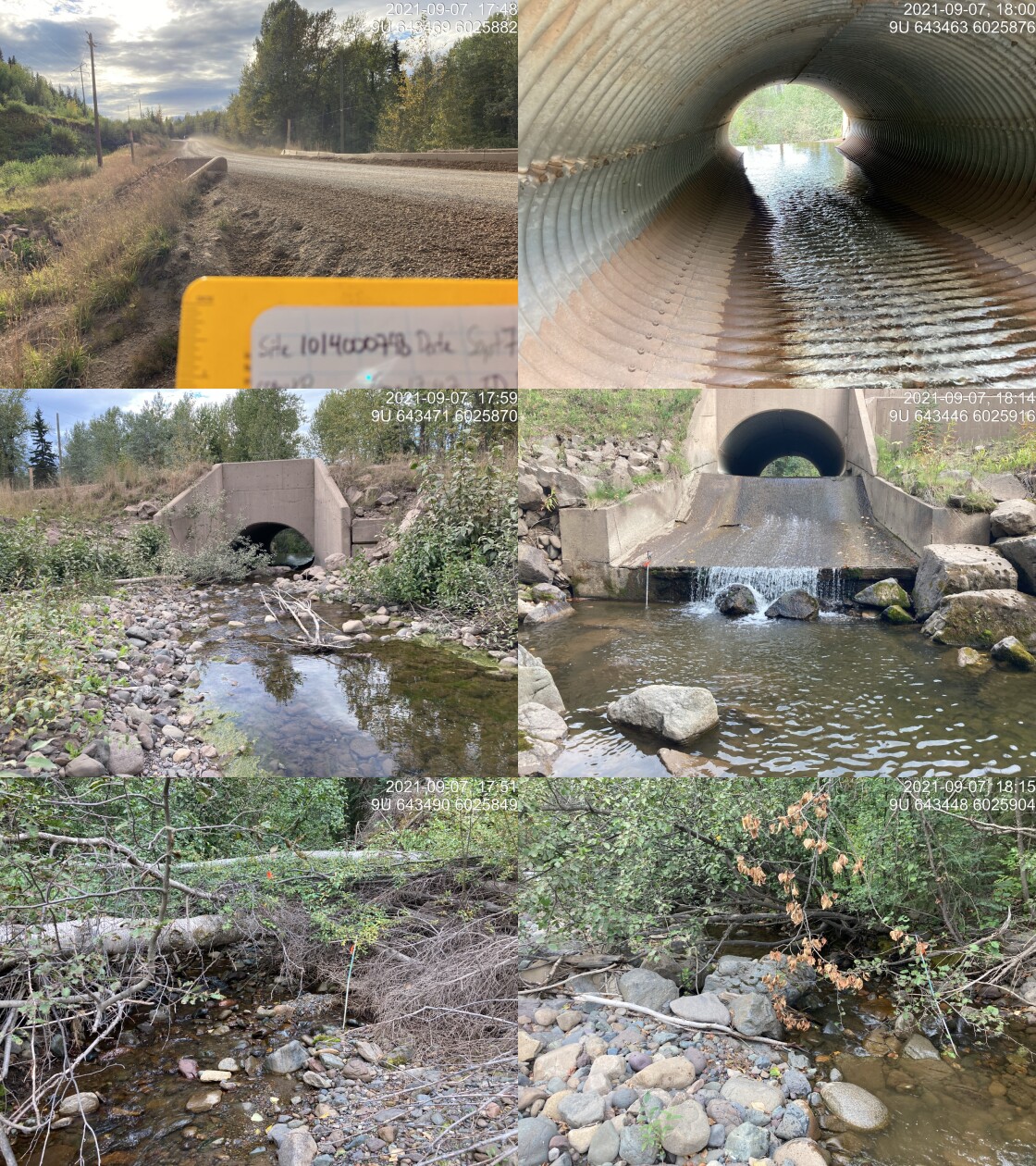
|
|||
| Comments: Partial inlet drop of varying height due to large woody debris and boulders. Side channel dry, must be seasonal use only. 17:47 |
Stream Characteristics Downstream
The stream was surveyed downstream from crossing 197962 for 600m
(Figures 5.69 - 5.70).
The dominant substrate was cobbles with boulders sub-dominant.The average channel width was 8.1m, the average wetted width was 4.2m, and the average gradient was 2.6%.Total cover amount was rated as moderate with undercut banks dominant. Cover was also present as small woody debris, large woody debris, boulders, deep pools, and overhanging vegetation.
Multiple areas of side channels and small braided sections were noted with intermittent sections of aggraded cobbles / gravels moved in high flows. There were pockets of gravel present suitable for spawning resident and anadromous salmonids.
The complex habitat was rated as high value for salmonid rearing and spawning.
Stream Characteristics Upstream
The stream was surveyed upstream from crossing 197962 for 750m (Figures 5.71 - 5.72). Total cover amount was rated as moderate with boulders dominant. Cover was also present as small woody debris, large woody debris, undercut banks, and deep pools.The average channel width was 6.9m, the average wetted width was 3.6m, and the average gradient was 2.8%.The dominant substrate was cobbles with boulders sub-dominant. Survey notes indicate signs of high powerful flows, including clumped large woody debris. Patches of gravels suitable for spawning were present. Habitat value was rated as high as the surveyed area was considered an important migration corridor containing suitable spawning habitat and having high rearing potential.
Fish Sampling
Multipass electrofishing was conducted at three sites upstream of the crossing and three sites downstream. Results are summarised in Tables 5.53 - 5.54 and Figure 5.66. Photos are provided in Figures 5.67 - 5.68.
Structure Remediation and Cost
Through a collaboration between FLNR, Canfor and Coastal Gaslink, PSCIS crossing 197962 was remediated in the fall of 2021 shortly after habitat confirmation field assessments were completed.
Conclusion
Access was restored to an estimated 4.8km of habitat modelled upstream of crossing 197962 due to the replacement of the culvert with a clear span bridge. Although numerous dolly varden and several rainbow trout were captured upstream, coho salmon were captured downstream only before the site restoration indicating that 197962 was a complete barrier to upstream fish passage. The completion of three multi-pass closed electrofishing sites both upstream and downstream of the crossing can provide baseline data for future effectiveness monitoring at the site to track changes in fish population structure resulting from the works.
tab_hab_summary %>%
  filter(Site  == my_site) %>%
  # select(-Site) %>%
  fpr::fpr_kable(caption_text = paste0('Summary of habitat details for PSCIS crossing ', my_site, '.'),
scroll = F) | Site | Location | Length Surveyed (m) | Channel Width (m) | Wetted Width (m) | Pool Depth (m) | Gradient (%) | Total Cover | Habitat Value |
|---|---|---|---|---|---|---|---|---|
| 197962 | Downstream | 600 | 8.1 | 4.2 | 0.4 | 2.6 | moderate | high |
| 197962 | Upstream | 750 | 6.9 | 3.6 | 0.4 | 2.8 | moderate | high |
| site | passes | ef_length_m | ef_width_m | area_m2 | enclosure |
|---|---|---|---|---|---|
| 197962_ds_ef1 | 3 | 14.2 | 4.83 | 68.6 | Closed |
| 197962_ds_ef2 | 3 | 6.8 | 4.63 | 31.5 | Closed |
| 197962_ds_ef3 | 3 | 7.1 | 2.90 | 20.6 | Closed |
| 197962_us_ef1 | 3 | 7.2 | 3.87 | 27.9 | Closed |
| 197962_us_ef2 | 3 | 5.7 | 4.97 | 28.3 | Closed |
| 197962_us_ef3 | 3 | 7.0 | 5.27 | 36.9 | Closed |
| local_name | species_code | life_stage | catch | density_100m2 | nfc_pass |
|---|---|---|---|---|---|
| 197962_ds_ef1 | CO | fry | 1 | 1.5 | TRUE |
| 197962_ds_ef1 | CO | parr | 1 | 1.5 | TRUE |
| 197962_ds_ef1 | CT | parr | 1 | 1.5 | TRUE |
| 197962_ds_ef1 | DV | fry | 3 | 4.4 | FALSE |
| 197962_ds_ef1 | DV | parr | 5 | 7.3 | FALSE |
| 197962_ds_ef1 | DV | adult | 1 | 1.5 | TRUE |
| 197962_ds_ef1 | RB | fry | 3 | 4.4 | FALSE |
| 197962_ds_ef1 | RB | parr | 9 | 13.1 | TRUE |
| 197962_ds_ef1 | RB | juvenile | 1 | 1.5 | FALSE |
| 197962_ds_ef2 | DV | fry | 2 | 6.3 | TRUE |
| 197962_ds_ef2 | DV | parr | 3 | 9.5 | TRUE |
| 197962_ds_ef2 | DV | juvenile | 1 | 3.2 | TRUE |
| 197962_ds_ef2 | NFC | – | 0 | 0.0 | TRUE |
| 197962_ds_ef2 | RB | fry | 5 | 15.9 | TRUE |
| 197962_ds_ef2 | RB | parr | 4 | 12.7 | TRUE |
| 197962_ds_ef3 | CO | fry | 1 | 4.9 | TRUE |
| 197962_ds_ef3 | CO | parr | 7 | 34.0 | TRUE |
| 197962_ds_ef3 | DV | fry | 1 | 4.9 | TRUE |
| 197962_ds_ef3 | NFC | – | 0 | 0.0 | TRUE |
| 197962_ds_ef3 | RB | fry | 1 | 4.9 | TRUE |
| 197962_ds_ef3 | RB | parr | 3 | 14.6 | TRUE |
| 197962_us_ef1 | DV | fry | 8 | 28.7 | TRUE |
| 197962_us_ef1 | DV | parr | 6 | 21.5 | FALSE |
| 197962_us_ef1 | DV | juvenile | 2 | 7.2 | TRUE |
| 197962_us_ef1 | RB | juvenile | 1 | 3.6 | TRUE |
| 197962_us_ef2 | DV | fry | 5 | 17.7 | TRUE |
| 197962_us_ef2 | DV | parr | 2 | 7.1 | TRUE |
| 197962_us_ef2 | DV | juvenile | 1 | 3.5 | FALSE |
| 197962_us_ef2 | DV | adult | 1 | 3.5 | TRUE |
| 197962_us_ef3 | DV | fry | 6 | 16.3 | TRUE |
| 197962_us_ef3 | DV | parr | 7 | 19.0 | FALSE |
| 197962_us_ef3 | DV | juvenile | 2 | 5.4 | TRUE |
| 197962_us_ef3 | RB | juvenile | 1 | 2.7 | TRUE |
| 197962_us_ef3 | RB | adult | 1 | 2.7 | TRUE |
|
* nfc_pass FALSE means fish were captured in final pass indicating more fish of this species/lifestage may have remained in site. Mark-recaptured required to reduce uncertainties. |
my_caption <- paste0('Densites of fish (fish/100m2) capture upstream and downstream of PSCIS crossing ', my_site, '.')

fpr_plot_fish_box(sit = my_site) 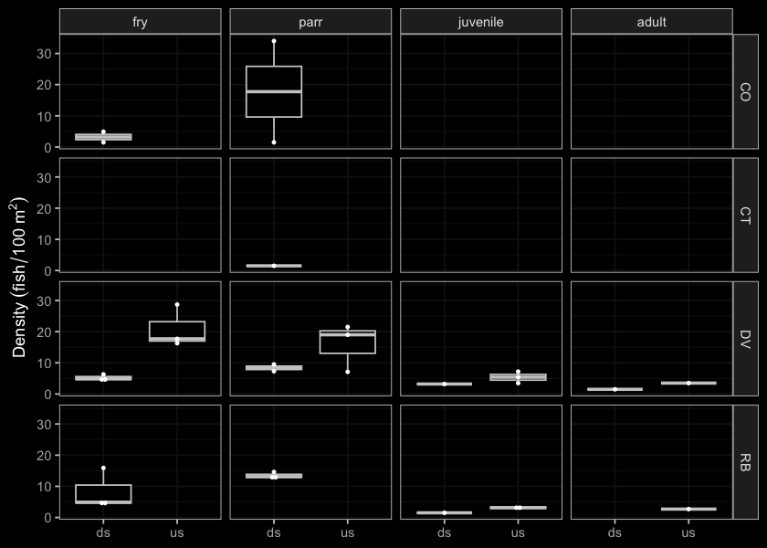
Figure 5.66: Densites of fish (fish/100m2) capture upstream and downstream of PSCIS crossing 197962.
my_photo1 = fpr::fpr_photo_pull_by_str(str_to_pull = 'ds_ef1_')

my_caption1 = paste0('Closed electrofishing site downstream of PSCIS crossing ', my_site, '.')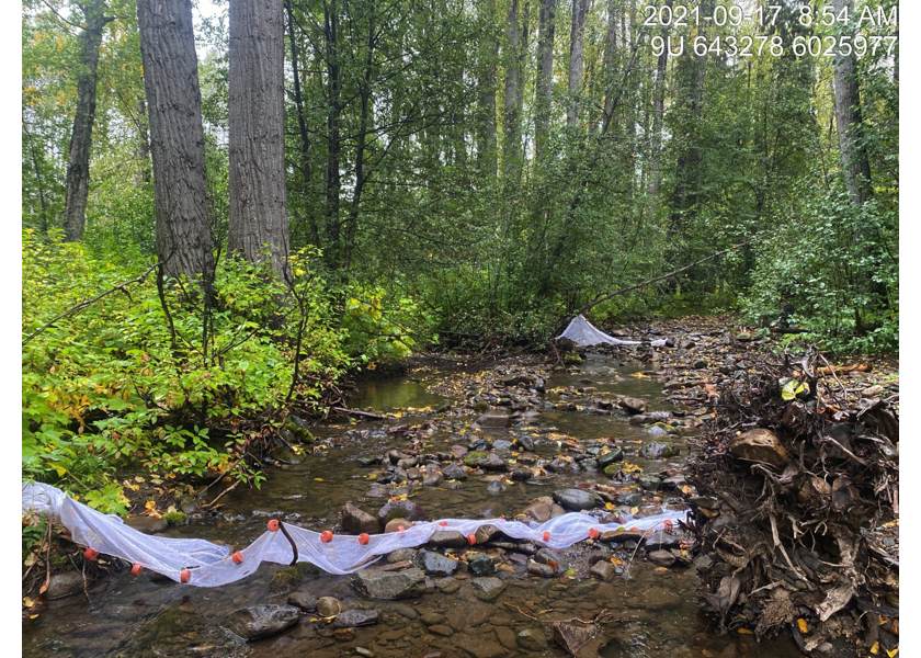
Figure 5.67: Closed electrofishing site downstream of PSCIS crossing 197962.
my_photo2 = fpr::fpr_photo_pull_by_str(str_to_pull = 'us_ef1_')

my_caption2 = paste0('Closed electrofishing site upstream of PSCIS crossing ', my_site, '.')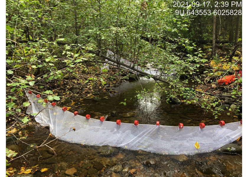
Figure 5.68: Closed electrofishing site upstream of PSCIS crossing 197962.
my_caption <- paste0('Left: ', my_caption1, ' Right: ', my_caption2)

knitr::include_graphics(my_photo1)
knitr::include_graphics("fig/pixel.png")
knitr::include_graphics(my_photo2)
my_photo1 = fpr::fpr_photo_pull_by_str(str_to_pull = '_d1_')
my_caption1 = paste0('Habitat downstream of PSCIS crossing ', my_site, '.')
# fpr::fpr_photo_flip(site_id = 1802488, str_to_pull = '6257')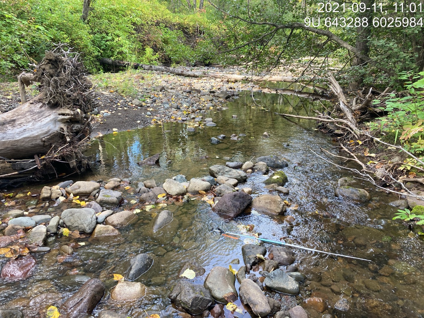
Figure 5.69: Habitat downstream of PSCIS crossing 197962.
my_photo2 = fpr::fpr_photo_pull_by_str(str_to_pull = '_d2_')

my_caption2 = paste0('Habitat downstream of PSCIS crossing ', my_site, '.')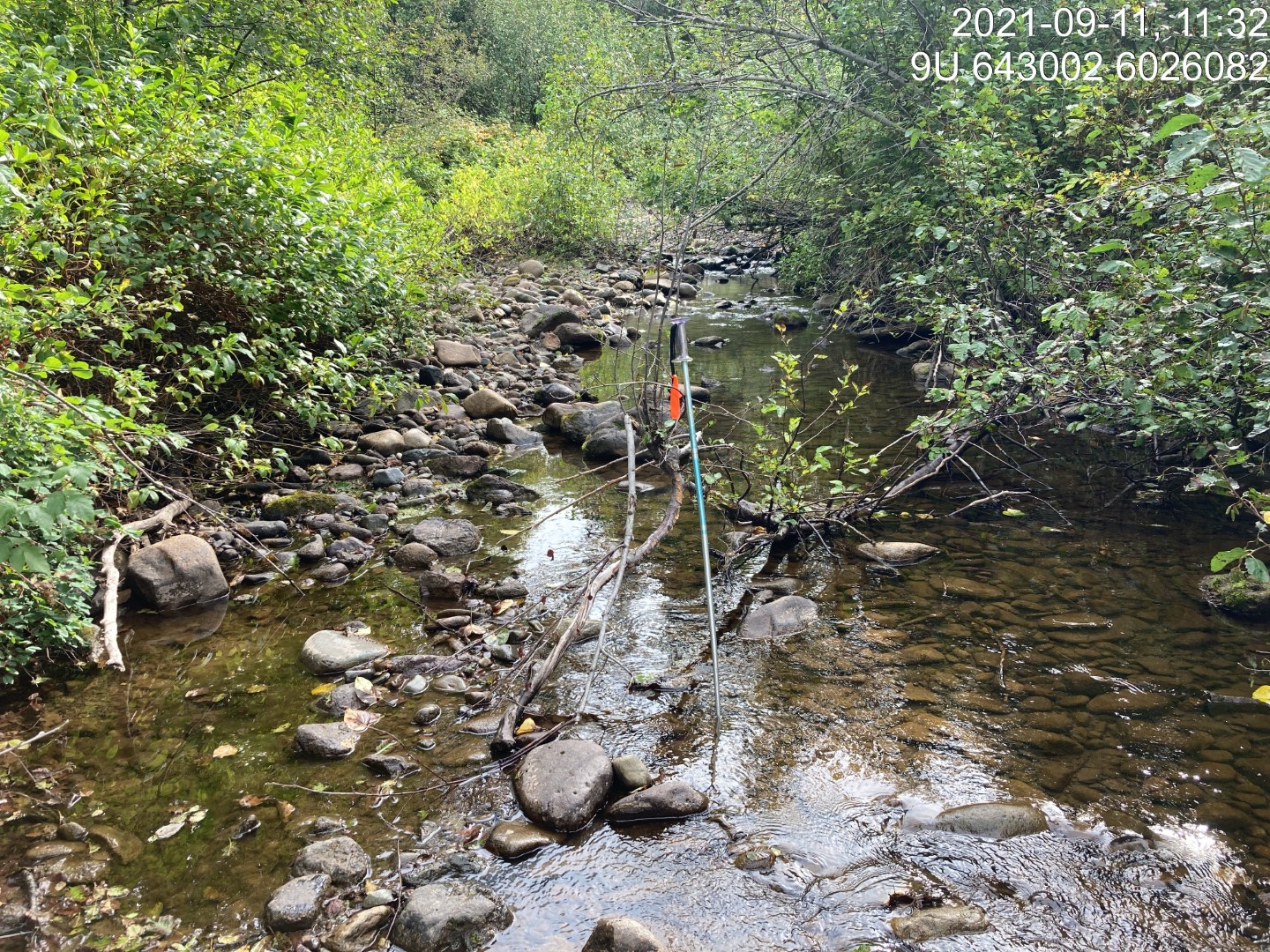
Figure 5.70: Habitat downstream of PSCIS crossing 197962.
my_caption <- paste0('Left: ', my_caption1, ' Right: ', my_caption2)

knitr::include_graphics(my_photo1)
knitr::include_graphics("fig/pixel.png")
knitr::include_graphics(my_photo2)
my_photo1 = fpr::fpr_photo_pull_by_str(str_to_pull = '_u1_')
my_caption1 = paste0('Habitat upstream of PSCIS crossing ', my_site, '.')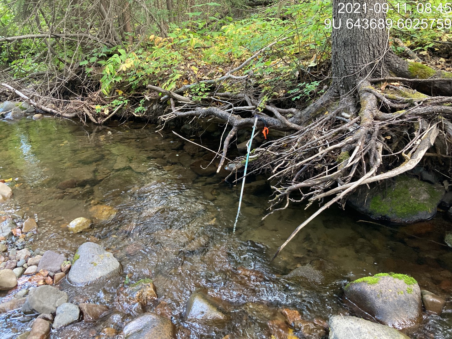
Figure 5.71: Habitat upstream of PSCIS crossing 197962.
my_photo2 = fpr::fpr_photo_pull_by_str(str_to_pull = '_u2_')

my_caption2 = paste0('Habitat upstream of PSCIS crossing ', my_site, '.')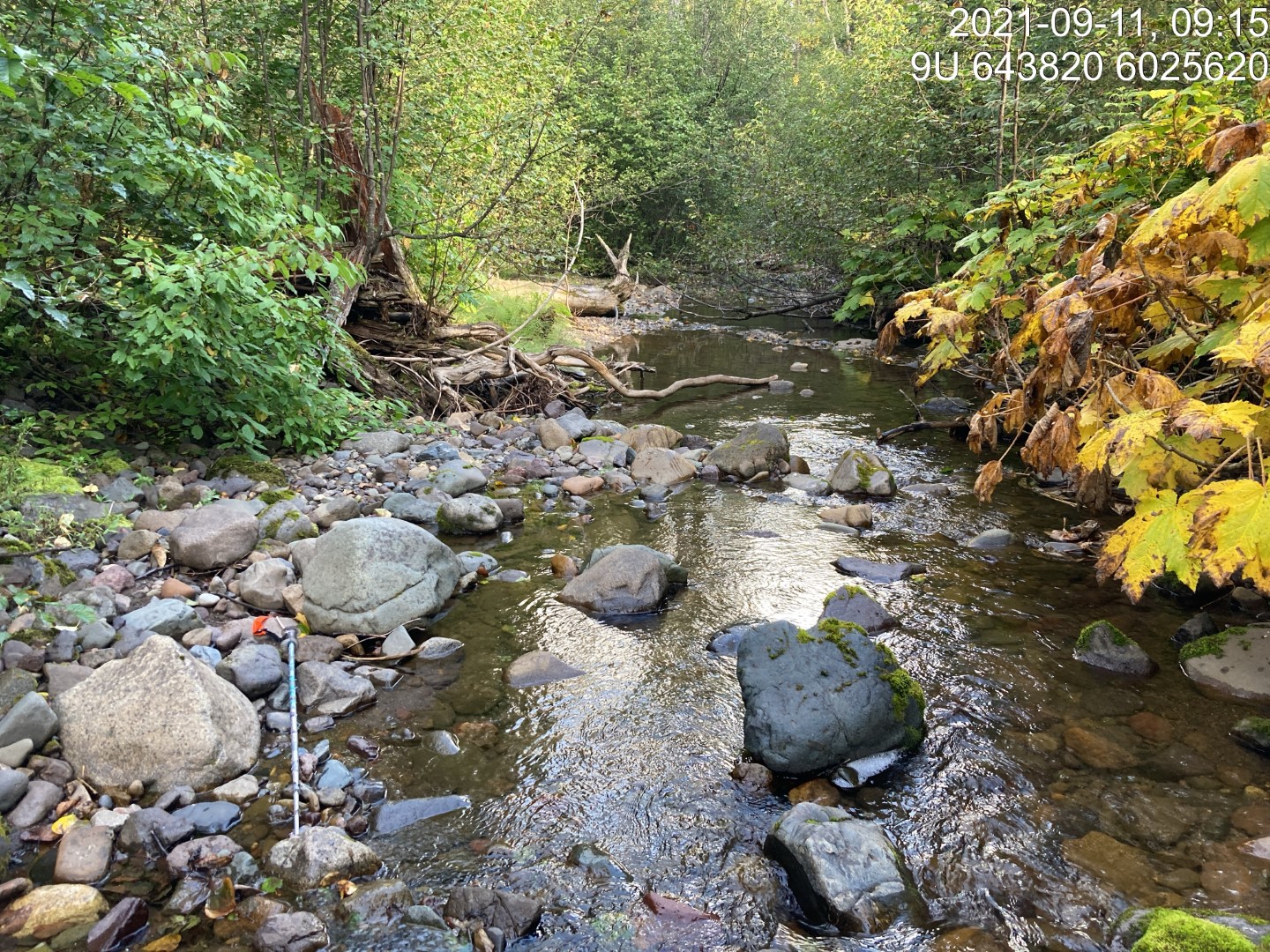
Figure 5.72: Habitat upstream of PSCIS crossing 197962.
my_caption <- paste0('Left: ', my_caption1, ' Right: ', my_caption2)

knitr::include_graphics(my_photo1)
knitr::include_graphics("fig/pixel.png")
knitr::include_graphics(my_photo2)